Gascogine Road Church, Kowloon
Looking for help to identify these photos my grandfather took when he was in Hong Kong with the British Army in the 1950s. I've carried out some research by looking at old photos but with limited success. The photos have also been shared with a number of Facebook forums. I'm really grateful for any help anyone can give as my goal is to build an album showing my grandfather's photos against the modern day photos of our time in Hong Kong.
Date picture taken
1950s
Gallery
Shows place(s)
Comments
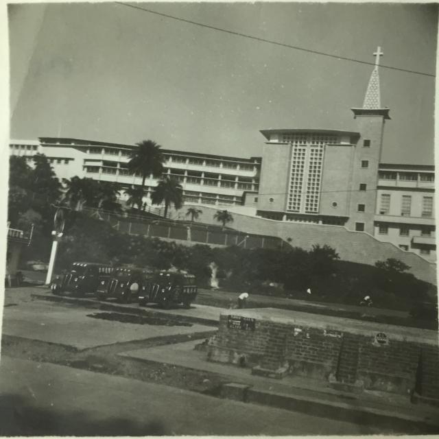
Kowloon Methodist Church
Kowloon Methodist Church at Gascoigne Road. Note the brick structures in the foreground, not sure if they were related previously to the air raid shelters across the road.
Re: Would the brick structure be some sort of a tank?
Hi there,
There is a white on black sign there which read 5000 Gals. Is it some sort of a tank for the Gasoline Station next to it? There is another sign a bit further to the right. A round sign with 13 on top of 5000. I wonder what is that. The 5000 is likely somewhat related to the 5000 Gals sign, but 13? Category 13 dangerous goods?
Just my wild guess.....
T
Missed the cars!
My grandfather taking a photo of a petrol station makes far more sense than him photographing a church ;-)
This is at the junction of
This is at the junction of Gascoigne Road and Nathan Road: The Caltex Filling Station is in the left foreground - which accounts for the cars and the 'gas' references. I've got a couple of views of roughly the same site taken in the mid sixties (but I can't see how I can add them here).
Tanks
We've seen that type of tank before:
Henry Ching explained that:
The concrete platform in the middle of the patch of grass in front of the hotel was a water tank constructed of bricks with a concrete roof. These tanks were built all over the urban area and could still be seen late into the 1950s. I think they were intended to supplement the water supply in case of fire.
Mid-60s view
Hi Tony,
Yes please, it'll be great to see how this area looked in the 60s. (Thanks for the email with the tram photo too, that'll be another good one to upload.)
Here are some notes on how to upload photos:
http://gwulo.com/node/2076
Hopefully they're clear to follow, but let me know if you have any questions.
Regards, David
Hi David
Hi David
I've tried - but can't find a way of loading the pictures into this thread. They have left my computer at least!
Thanks to David's advice now loaded below:-
Tony
Loading pictures
Hi Tony,
Your photos are on the site and look good. Here's the next step to insert them into a comment:
http://gwulo.com/node/1929
Regards, David
Junction of Gascoigne and Jordan Road
Thanks. Noted the explanation given. Perhaps sea water tanks for the Fire Brigade given the water restrictions in force in 1950/1951.
Re: Tank 13 then
Hi there,
So the round sign would likely be Tank 13/5000 Gallons. But I now realize the other sign on the left hand side reads 5000 Gals, with an arrow pointing towards North, and 890 Ft Cliff Road.
The question is why it was pointing to Cliff Road? Cliff Road is a very short dead end street nearby where there is an ARP Portal facing north. Was there some important installments on Cliff Road? There is a Fire Hydrant on southbound Nathan Road near Wing Sing Lane though where the lane led up to Cliff Road.
T
Cliff Road
Just a guess, but perhaps on one tank they'd point to the nearest alternative tank in case you needed extra water? Hopefully we'll get a closeup of another tank to see if it was a common practice.
Regards, David
gas station
Here is the complete view of the gas station (petrol station) in front of the Gascoigne church. Date is 1959.
By the way, there is a path in front of the "zigzag" wall and the church which leads uphill to the Methodist primary and secondary school (methodist college).