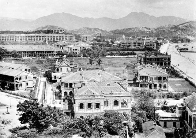
Retouched (levels adjusted) copy of photo from the HK Public Library collection, entitled "Chatham Road, showing Knutsford Terrace and Observatory. Rosary Church on the left and Gun Club Hill on the right".
Date picture taken
1908
Gallery
Shows place(s)

Comments
A good view of Knutsford Terrace
showing it's (then) breezy location, with views across TST towards the harbour and HK island. No doubt the residents grumbled as buildings went up in front, blocking their view. Some things never change!
Re: This might have shown the approximate location
Hi there,
This photo might have shown the approximate location of the photographer of another photo in question.
Best Regards,
T
Mody Road at Hanoi and Hart
Hanoi Rd and Hart Ave are on the left. This 5-point junction retained their original configuration as shown in your other photos. Taken from Signal Hill, I believe, and looking north, it shows just beyond the trees the rear view of Lyton Hotel. I visited my classmate there in the 1950s as his father was its owner. Though small looking on the outside, its rooms and hallways were spacious and the staff kept the place incredibly clean. A few British officers stayed there. Last year, I returned to the site and reminsced those wonderful years, and lamented the loss of this beautiful building.
Thanks Old Timer, good to
Thanks Old Timer, good to have the building identified. I've added it to the Places Shown.
Regards, David
Observatory Villas
Think Observatory Villas can be seen left of Chatham Road after the bend.
Cameron Road runs across the
Cameron Road runs across the photo just above the center. North of the road are Dilkusha and the residential building on K.I.L. 537.
KIL's 517,518,524 are undeveloped.In the 1920s RAF temporary quarters will be located there.
St Mary's Canossian School
St Mary's Canossian School visible in the extreme right upper corner near Chatham Road.
Pinpointing Observatory Villas?
David
Is it possible to put an arrow on Observatory Villas? My family lived there in 1906. I don't know what Chatham Road looks like. The HK Telegraph of 6 Jan 1905 claimed that six of the planned twenty two houses would be completed by June and that they were designed by John Lemm. The site was owned by A.V. Apcar according to the article. If I understand the article correctly, the name "Observatory Villas" had still to be officially given.
Observatory Villas
Jill, here's a close-up photo from about 1901 when the villas were still under construction:
The first one of the villas is the building in the center, next villa left of it. This might help to identify the villas on the 1908 photo.
Regards, Klaus
Position of Observatory Villas 1908
Perhaps they are the buildings up against the lefthand margin of the 1908 photo, if that accords with the bend in the road that you mentioned earlier?
Observatory Villas
Here's an enlarged part of the above photo showing the Observatory Villas.
More of Observatory Villas
Thanks again, Klaus. Probably this would be the six original houses referred to in the HK Telegraph article of 1905? I can't see much space for the garden referred to in front of each and the tennis court behind, but perhaps it's the perspective. It's also interesting for me to see the Rosary Church where my father was christened in 1909.
Observatory Villas
Would number one Observatory Road be opposite the villas? That was where my mother lived as a child (would be back in the 20s/30s) according to information I was given. I'm not sure if today's numbering system (Observatory Villas occupying the site now numbered 2-8) is relevant or not? If anyone can answer this, would be most grateful.
re: Observatory Villas
I checked the 1938 Street Index, which shows Observatory Road on printed pages 262 & 263 (images 478 & 481 in the viewer).
At that time, the only odd numbered buildings were numbers 15, 17, & 19.
Observatory Villas were numbered 1-6 inclusive, so perhaps your mother lived at 1 Observatory Villas?
What was her father's surname? His address may be listed in the Jurors Lists.