The reverse of this photo, which is from family archives, says: "Do you recognise this spot, Arrow denotes our flat". What is left of the arrow is on the top left hand corner which I have cropped away.
It would be good to identify the area or road. Many thanks.
Date picture taken
1920s
Gallery
Shows place(s)
Shows street(s)
Comments
It doesn't look like Hong
It doesn't look like Hong Kong, couldn't see any hill in the background....
No backgound hill
I assume it is Hong Kong bcause another photo in the set shows my great aunt and uncle standing outside a Chinese style building and on the reverse the message says is is near "our flat and the children's playground".
Their marriage broke up in the late 1920s and my uincle, Charles W Olson went to Canada. Don't know what happened to his wife.
The pictures were sent to their nephews at school in England. The onlyy other possibility is that it is in Canton or Shanghai where the family also had houses but I am not sure they would have pictures of anything else but HK to the boys.
Does that help anybody?
Re: Where is this?
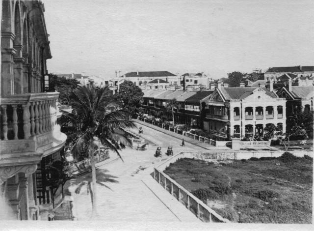
When I looked at your photo, I recognised that it was taken in Tsim Sha Tsui, Kowloon around the Carnarvon Road triangular junction area.
Between 1923 and 1924, Charles William Olson lived at 7 Prat Buildings, Kowloon. I have created a place for its location based on the photo received and the road layout:
http://gwulo.com/node/5812
In the original photo, the road in the foreground is Prat Avenue. Carnarvon Road runs in from the right and makes a disgonal turn to the left. The vertical road in the centre is Humphreys Avenue.
1920s Carnarvon Road looking towards Cornwall Avenue.
The building in the centre of the colour postcard is Humphrey's Building. Carnarvon Road swings left. I think Prat Avenue is out of sight behind the cream-coloured building at mid-left.
I would be interested to have a look at the photo that you mentioned of the flat and the children's playground.
Hope this helps. Cheers!
re: Where is this?
Thanks for pin-pointing the location of Sean's photo. I was struggling!
I don't think we've got the orientation for the colour card quite right though. If you look at the building in Sean's photo on the corner of Humphreys and Carnarvon, you'll see that its two outward-facing sides look quite different.
The facade of the pink building we see on the left of the colour photo matches the side facing Carnarvon Road in Sean's photo, not the one facing Humphreys. That suggests the colour photo shows a view looking north up Carnarvon Road - but then the angled junction at the end doesn't seem to match any roads in that area. So that doesn't seem quite right either. Any idea what I'm missing?
Another suggestion is for the location of the building in the left foreground of Sean's photo, where CW Olson was staying. From the photo I think it's on the corner of Prat to the north and Hart to the south. That would move it a bit east from the current marker for the place, to roughly where Rose Mansion stands today.
Finally, I went looking for some dates for when this area was built and found an entry in the Gazette dated 4th Feb 1921. It announced that the 'Road beginning at Hart Avenue and running in an easterly direction across K.I.L. 417 and terminating in a a cul-de-sac at the west boundary of K.I.L 418' would in future be known as 'Prat Avenue'.
Page 22 of the report on Public Works for 1921 also gives it a mention: "a block of flats on Prat Avenue was erected and the erection of other blocks was commenced".
Re: Where is this?
David, I haved moved the place marker to Rose Mansions. I think we agree that Olson's buidling is in the vicinity of the Prat/Carnarvon/Humphreys Avenue triangular junction.
I did note the views of the pink building facing both roads (Humphrey's & Carnarvon) were different. However, at the time I was more focused on pinpointing the general location of Olson's residence than concentrating on the pink buidling on the corner.
Now, that I have time to compare Sean's photo and the Carnarvon Road postcard again, I agree that the pink building that is seen on the left of the colour postcard matches the side facing Carnarvon Road. I will amend the photo caption accordingly.
To provide more positive identification of the general area, here is a postcard of the pink building at the corner of Humphrey's and Carnarvon which I date to the 1910s. The open grassy area in Sean's photo is seen in the foreground.
Humphreys, Carnarvon, Prat photos
I'm also trying to locate a picture showing where my family lived and hopefully be able to pinpoint it in one of the photos on the Gwulo site. My grandparents Tobias and Maud Hunter lived at 4 Humphreys, Kowloon and the year was 1911. Tobias worked for Jardine Matheson at that time. I also have an address a year later when her sister was born, of 5 Carnarvon Villas which was likely in that same area
My maternal grandparents William and Harriet Thomson lived at 21 Robinson Road, Hong Kong and he worked for the Public Works Dept
re: Humphreys, Carnarvon, Prat photos
4, Humphreys Avenue should be one of the buildings in the photo immediately above your comment. Humphreys Ave is the road heading away from us, on the right of the ladies.
I've made a page for William Thomson at:
https://gwulo.com/node/19881
Regards, David
re Humphrey's Ave
Davd,
There have been several posts on this subject. It might be worth putting them all together. Incidentally, in one of them I mentioned my uncle William Oswald Olson was born there in 1910.
Just a thought.
Sean
The pink building
Idon't think the said pink buildings are the same in these 3 photos. Note the locations of the chimneys and the structure of the roofs.
Re: Pink Building
Yes, the pink buildings was on the northern side of Carnarvon Road and out of sight in the other photos/postcards. I have created a place for 1-4 Carnarvon Villas here