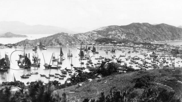
Where: Looking north across the harbour at Cheung Chau.
What: Let's start with the few buildings we can see on the far shore:


I guess they're shipyards, building and repairing the local junks & sampans. There looks to be a boat pulled up on a slip in front of each shed.
How about this one?

No boats nearby, but I can't see any easy path to this building over the land, again suggesting its business lay with the sea.
A bit further to the right and the steep hillside runs down to the flat stretch of land that forms the centre of the island:

The hillside looks to be terraced. Was it a garden / farming area?
The terraces are edged by a neat sea-wall, a taste of what would follow. Most of the shore is still a sloping beach in this photo, but today a sea-wall runs the length of the shore.
Further round is another stretch of sea wall, with open land behind it:

Would that be the open space that's in front of the Pak Tai Temple [1] today? Also interesting to see the trees. There'd have been a strong demand for firewood from the village and fishermen, so I wonder what kept these trees safe?
Further round again there's a building standing proudly above its neighbours, and with what looks like a decorated balcony along the front of the roof:

Can any Cheung Chau residents recognise it? There are still some old buildings around the village, so there's a chance it's still standing.
Before we leave the land, look at the bottom-right corner:

There look to have been three piers in use. The top one looks rather flimsy, but the next one down is a much more solid structure. Probably the government pier. In the foreground is the third.
Looking at old maps, I think these met the shore around Tung Wan Road - the same area where the two (much more recent) piers stand today.
Swinging back to the left, we head out to sea and this fleet of sampans:

Today we think of sampans as transport, but at this time they were still homes for the many families who lived on the sea. When this photo was taken, do you think there were more people living on land at Cheung Chau, or more on boats? I'd be interested to know.
Further across is the one and only boat in the harbour that wasn't powered by wind or muscle-power:

Was it a ferry? Its shape certainly looks similar to the older inter-island ferries around Hong Kong.
And finally, what paid the bills:

Junks from the island's fishing fleet, hanging out their nets to dry.
When: Here's the back of the card:

Not much to go on. I don't know a firm date range for the "Oriental Bromide Paper" stamp box. There are a few mentions on the internet of other postcards that use this paper, showing views from the 1920s and 30s. I'll guess 1930 - corrections welcome!
Who: Postcards sell to tourists, so they show places that tourists would visit and then want to remember or write home about. We don't see many postcards of the islands or New Territories in the 1920s / 30s, so what made Cheung Chau different?
In 1919, the south-east section of the island was set aside as a European-only residential area [2]. It was intended to provide accomodation for the various missionary groups who'd been priced out from buying land on Hong Kong island, and a side effect was a steady supply of visitors needing postcards!
I know very little about Cheung Chau's history, so if you can tell us any more about what we're looking at in this photo, I'll be very interested to hear from you.
Regards, David
References:
- Pak Tai Temple, Cheung Chau
- For some notes about the European reservation area on Cheung Chau, see the notes and comments to this photo. Several of the old stones that marked out the boundary of the European area still exist, and are described in these notes & photos.
Reference: EC036
Comments
1920s Cheung Chau
Barbara Anslow writes:
When we Redwoods lived in Hong Kong 1927-1929, the Naval Dockyard used to run weekly launch picnics to the various beaches,one of which was Cheung Chau. In those days the island had little to recommend it, as your photos suggest.
The thing I remember most about Cheung Chau was the constant fishy smell. As you suggest, fishing was a great industry there, lots of fish always hung up to dry. My mother told us that fish paste was made there and associated this with a then well-known tinned paste firm called Machonikees (I've no idea how to spell that!) and declared she would never buy their paste again: whether she was just guessing that paste was made there, I don't know.
Thanks for posting such a
Thanks for posting such a detailed scan of this postcard!
I am in my early 40s and my family (maternal) has been living on Cheung Chau for at least 5 generations. I think a few of the buidings may still be standing, consider the photo was taken in the 30s, though I have a hard time picking them out.
As for that 'modern' looking ferry, there's a good chance that it's the motor vessel "Sun Chau", built to order of the Hong Kong and New Territories Ferry Co. Ltd.. It was launched in 1929. The following is the description of the ferry by the China Mail:
"The vessel is 120' 0" between parpendiculars, 23' 6" beam and 10' 9" moulded depth, and has one complete deck with long bridge. Built to scantlings approved by the Hong Kong Government, the veseel is designed to carry 300 passengers. Electric light is fitted throughout, and all necessary life-saving appliances as required.."
The newspaper report goes on to report that if the service was to become a success, the ferry company would add 6 others.
I am doing some researches myself on the colonial history of Cheung Chau, and the earliest record I can find of Europeans/Americans living on the island is dated late 1900s, by when several houses were already built. A long article appeared in Hong Kong Daily Press in 1909 reads like an advertisement of a holiday resort:
"The feature of life at Cheung Chau which will appeal to most people is the general or communal bathing. Just when the sun begins to drop,.. there may be seen men and women attired in bathing costumes and topees, accompanied by their children, .. wending their way down the slopes of the island to the beautiful little stretch of white sand, which is now recognised and reserved as the foreign bathing place. (* referring no doubt to Kun Yam Beach) ..
It does one good to see so many happy folks, and when one has enjoyed a swim there and climbed a hill in the same light attire in which he came down .., then one has tasted something of the joy which Cheung Chau offers to the visitor ... To inhale its fresh breezes laden with health-giving ozone, to sit in a chair in the cool and claim of the evening and come under its restful spell, .. to turn the eyes toward Hong Kong and look at the glittering lights of the Peak - these are a few pleasures of this island life."
And by 1920s there was a sizable community of foreigners, so much so that their local resident meetings were newsworthy. I would definitely like to share more once I have the information organized.
Old Cheung Chau
Hi Sean, Thanks for sharing your research with us. I'll be interested to read more of it as it becomes available.
Regards, David
The "terraces" on the
The "terraces" on the hillside are open areas for sun drying fruits, such as peaches, cherries.
Daniel
The terraces
Thanks Daniel, there's a little bit more information about them at https://gwulo.com/node/29220