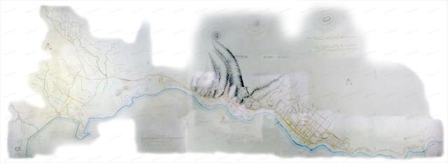
Here's a detailed, zoomable, scrollable, clickable map of Hong Kong from 1845, showing the north of the island from Shek Tong Tsui across to Tin Hau, plus the area around Happy Valley. The view above shows the map as drawn, then please click here to see it rotated and overlayed on a modern map of Hong Kong.
<?php
print views_embed_view('places_by_lat_lon', 'page_3', "22.27678,114.1646_0.01151,0.03004");
?>
(If you haven't used these maps before, you can read instructions here.)
Where's it from?
A few weeks back I was in London and made a couple of visits to the National Archive. I went looking for maps, and this was my favourite from the collection I saw.
The first impression is how big it is. You request a document via their terminals, then when it's ready you go to the desk and collect the original. Some maps were just small slips of paper, but this was a large rolled map. I'd guess it was around a metre from top to bottom, and several metres wide when rolled out.
I took photos across the map, then reassembled them on the computer when I was back in Hong Kong. (To get a feeling of the size, it's a 234-megapixel image!). The colours look more even in real life, but I've made some adjustments to make it easier to read.
Here's the National Archive's reference if you'd like to see the original, or if you need to contact them about using the map for any commercial purposes: WO 78/479
What was it drawn for?
The handwritten note at the top of the map reads:
Plan of Victoria, Hong Kong. Copied from the Surveyor Generals Dept. To accompany the Reports of the Respective Officers dated 12 ??? 1845.
The land rises abruptly from the North Shore in steep ridges and deep ravines terminating in a lofty ridge extending from East to West, this ridge again rising into numerous peaks.
The shaded portion shows the formation of the land in the Military Cantonment, particularly about the site proposed by the ???? Engineer for the Ordnance Establishment.
What can you see?
I haven't seen a map from this time with this level of detail before, so I'm hoping it will tell us more about the early days of Hong Kong. If you see anything that catches your eye, or answers any questions, please leave a comment below.
It's taken around a week's work to get it to this stage. I'd like to show some more, but I'd like to know they're useful first.
Regards, David
Comments
Terrific
Terrfic stuff. Well done David on such a rare and important find and thanks for the effort and time you've spent making it available here. Just one thing - the homepage and this page seem to have slowed down considerably, perhaps due to the inclusion of the Google Map.
cheers, Adam
Wonderful
Thanks David. What a wonderful map. Fascinating to see where various places I seem to know from reading the questions and answers on the site are in relation to HK as it was all those years ago. Must say Marine Lot 111 is a long way from the sea now!
Thanks again,
Sean
Wow ! Thanks so much. What
Wow ! Thanks so much. What fun you must have had in the map room :)
Does that mean Jardine's Bazaar the longest running shopping street in Hong Kong ?
Morgan's Bung
That is fantastic! So interesting... I wonder what "Morgan's Bung" was, what it looked like (a homestead in the woods?) and who was Morgan? You can get lost in these thoughts...
Morgan
Eitel (Europe in China, page 174) lists a Captain Morgan among the purchasers of the first 100 lots in 1841. Bung was probably Bungalow.
Short for "Morgan's
Short for "Morgan's Bungalow"
I've created a "place" here http://gwulo.com/node/8223
1845 Map
Thanks very much for the postitive feedback.
Adam, I hadn't noticed the slowdown til you pointed it out. This page will still be slower than normal (there's more going on behind the scenes), but I've taken the map off the homepage to stop it slowing down. Thanks for pointing it out.
Annelise, thanks for creating the new places. And yes, a visit to the National Archive is a treat. Apart from seeing the stuff I'm interested in, it's also good to see the other documents that people are looking at - strange old documents, hundreds of years old and looking very fragile. It's amazing what they have, and that there is public access to these original old documents. Highly recommended.
Regards, David
1847 panorama
By email from Robin Seed:
I've put together a 3 panorama 360 view of HK Harbour in 1847. http://brianseed.com/1847.html Feel free to post this on Gwulo, it has been sold so, only available for reference.
Thanks to Robin for posting it - it's an interesting view in its own right, and it helps bring this map to life.
Regards, David
Morrison's Institution
I see a Morrison's Institution and Chinese Hospital where Morrison Hill is. Does anyone know what the institution was, or was it what I think it was: an institution next to a hospital to house the incurable?
There does not seem to be any mention of it in Gwulo.
Morrison's: Places to the rescue!
Hi Breskvar, the lower map on the page has markers showing Places. If you click on the markers around the area you described, you can see links to the Places, and click them to find out what we know about those buildings. (There's definitely room to know more, so please add anything more you find out to those Places)
Regards, David
School for Chinese students
Thanks David, clearly I don't know how to use the markers function well enough. Indeed it was not what I think it was. It was a school for Chinese students opened by Robert Morrison.
There's also a marker over
There's also a marker over the hospital building for the Place "The Hospital of the Medical Missionary Society 傳道會醫院 [1843-1853]".
Regards, David
Mercars House
the map shows a house entitled Mercars Ho. or Merears Ho. at the same locatiton of the current St Paul's Primary School on Wong Nai Chung Road in Happy Valley. Anyone have any knowledge of that? the current building dates from 1907 according to the govt.
"The School was originally an orphanage in the name of “Le Calvaire” operated under “Sisters of St. Paul de Charters”. It was completed in late 1907 and opened on 6 January 1908 by the then Governor, Sir Frederick Lugard accompanied by Bishop Pozzoni. During the Japanese Occupation, the site was once used as a police station and a jail.
In 1946, the orphanage ceased to operate and the building was used as a primary school from then on. The present name of the School, St. Paul’s Primary Catholic School, was adopted in 1960. It was accorded a Grade 2 status by the Antiquities Advisory Board in 1992 and is currently a proposed Grade 2 Historic Building under the assessment exercise of 1,444 historic buildings."
http://www.amo.gov.hk/form/150meeting/AAB150-55-Main.pdf
mercer's house
ah looks like the cartographer got the spelling wrong and it should be mercer's house, as mentioned here: http://gwulo.com/mathesons-bungalow
1845 map
The first time I have seen "West Point Barracks" marked on a map. Western district is still "Sai Ying Poon", or "western soldier's place" to local people.
1845 map
couple more observations on this incredibly useful map: the hill in Admiralty on which Flagstaff House sits is called Lord Saltoun's Hill, acfter Major General Saltoun who took over command of the troops in the city in November 1842.
(http://www.queensroyalsurreys.org.uk/colonels/024.html)
Second, the government public market has remained in the same spot in Sheung Wan since at least this date
Re: Government Market No 1?
Hi there,
If it is the Government Market No 1 I think it should be in Central as Cochrane Street was marked a bit south of it.
Best Regards,
T
re market
sorry that's where I mean, where the current 1930s market is
Mount Possession
That's a name on the map which caught my eye. I believe it's today's Victoria Peak. I wonder how widely the "Mount Possession" name was used initially, and when it changed to "Victoria Peak"?
Coordinates?
Somehow, I think it will be much easier for people to find the names and little points on the map that are discussed if we have a system of coordinates. An example will be "Morrison's Institution at Coords (x,y) on the map".
Right now, it is difficult to find the places being discussed. But of course, it's easy for me to suggest because I won't be working on them.
HK Club
Most sources seem to put the opening of the first Hongkong Club as May 1846, others as May 1845. I suppose the placement of a 'Club House' between D'Aguilar and Wyndham Streets on this map would mean it was more likely 1845, unless there was another shorter-lived club in this spot prior to the Hongkong Club's opening.
Coordinates
As you move your mouse over the map (the one with markers), in the bottom right corner you can see the coordinates of your position shown as latitude / longitude. (Though note there's currently a bug that means if you're viewing the map in full-screen mode, the lat / lon numbers aren't correct.)
There are some other ideas I have for making it easier to do what you describe, but that's the best way at the moment.
Regards, David
A different versiion of the
A different version of the 1845 map including many names not on the original:
1845 and other old maps
Dear David,
I have had such a fantastic time browsing through the 1845 and 1866 and other old maps of Hong Kong. I can trace how my great-grandfather Edward Newman in the early 1870s walked from his home in Old Bailey Street to the P& O offices on the Praya and after work to the Masonic club in Zetland Street. I can see where my mother Billie might go from her office in the Hong Kong Bank building to meet a friend at the Hong Kong Hotel in the late 1930s. And where I would have a drink at the FCC in the late 1970s. Ah, if there was a time machine...
Anyway, thanks for your excellent work.
Ian Gill
re: 1845 and other old maps
Thanks Ian, glad to hear the maps are being put to good use.
Best regards, David