If you hike around here, you'll likely come across this clearing, which contains the remains of an old building. Martin heyes wrote in by email with some information about it's more recent history, and a question about the old building:
[This] open space, which 30-odd years ago when I first went scrambling up there could be accurately described as a "clearing." Now nature has reclaimed it and with much vegetation it has become quite overgrown.
I feel sure that it was once a garden.
An American named Robert Gandt wrote a book in the mid-1970's about the 1941 battle, called "Season of Storms." Not bad, nothing brilliant - I have a dog-eared copy. In that book he describes the fighting that went on up there, and he mentions how the Japs attacked the pill-box from across the "clearing."
He then goes on to state how there was once a house up there which belonged to Matheson of Jardine Matheson fame - hence the garden - and indeed there is a wall there which presumably did belong to a house once.
But that is all.
Now I am very doubtful about that assertion. I feel it is unlikely that Matheson did have a house there. He did live in HK in the 1840's, unlike Jardine, but his house was in East Point, next to what is now the Excelsior Hotel
I am aware of the Jardine Matheson connection with Jardine's Lookout; how the hong used to station a young "griffin" on top of the hill with a spyglass to observe any Jardine ship entering the harbour. He would then gallop by pony down to East Point to inform his bosses. My guess is that any "house" up there was for use by these griffins when they weren't actually on the top of the hill - resting, eating, ablutions, changing horses etc. etc.
I wonder if any of your gwulo readers would be able to shed any light on what was the building up there?
We made a few notes about it when 80skid mentioned the Japanese tunnel just to the west of here.
80skid:
There's the remnants of a very thick wall since used as a temporary home in a clearing next to the bunkers, be curious to know what that was from.
David:
The AFCD website gives some background on the wall in the clearing:
One of [the historic sites] is the ruins of a bungalow on Jardine's Lookout. Once the residence of James Matheson, the original Scottish founder of Jardine Matheson & Co. Ltd., the bungalow is now reduced to a mere foundation.
80skid:
Find it amazing that this is the site of Jardine's old house - but could be I guess. what do people reckon?
Apparently his house was called Picnic Cottage, there's a pic and description of it here.
the site is a natural granite clearing, which is rare for the hills around there so removing the need to flatten any land. It is next to a stream. And you must have had a good view from there. There's some big red Chinese characters on the wall. Still not sure though.
David:
I had the opposite feeling when I visited - it seemed it had been purposely leveled. The rock there is easy to dig, which would have made it easy to level (and also an attractive area for people wanting to dig tunnels).
80skid:
well couldn't work out if it's been flattened or not - just seemed solid granite (hence no vegetation there) which would have made it hard to dig but I could be wrong. It's an interesting site though. nice place to play mahjong!
Can anyone add any more history about the clearing and its building?
Regards, David
Photos that show this Place
Comments
re: Mathesons bungalow
Hey David - great summary. I'm still intrigued by that place. Incidentally someone has cleared the lean-to on the wall which contained all the mah jong stuff. I wonder if military records might help, given the proximity of the bunkers (that were so fought over)
re: Mathesons bungalow
Not sure if the military records paid much attention to the history of what was around them - I think they probably had bigger things to worry about!
Do you think it was ever given a Lot number, or was it built in what must have seemed such a remote spot that no-one bothered?
re: mathesons building
well given the government owned all the land they should have a record of any sale, and so presumably a lot number. the thickness of the remaining wall suggests it was sizeable even if small. With the military records, I just wonder if something more substantial existed then, which they would have referenced - ie near the xx bungalow etc. It must have been a useful pointer given the lack of any other buildings in that area
Matheson Bungalow/Black Mount
Early parliamentary reports refer to Matheson's bungalow built on a place called Black Mount.
This interesting snippet from July 6 1843 by Land Officer A.T. Gordon gives his vision of the future colony. He says:
I believe I have referred to all the points connected with the survey of this side of the island ; and I now wish to notice the line of road to " Chek-Chiu " (only a small part of which will appear on that survey). The trace which has been made for that road, from the Queen's Road up to the top of the hill above the Wongnei-chung Valley, has been kept quite too low. It should be taken up the hill at the rear of lot marked No. 79 on the survey (known as Mr. Mercer's), passing with a gradual rise along the face of that ridge of hills under the bungalow built by Mr. Matheson ; and thus it will gain by one continuous ascent almost the highest point to be surmounted. I have not yet levelled over this line j therefore I cannot give the precise gradient; but I have gone over it often enough to satisfy myself that it is the only line of road to the top of those hills which will be available for carriages. This road to " Chek-Chu " will be the only main road across the island. The nature of the ground quite precludes any other for carriages ; and the Queen's Road, if continued (as I have suggested) round the island, will meet and unite with this one at " Tytam," and from it there will be branches to Saiwan and other places; while the way to " Shek-pae-wan." Hong Kong, &c. will be by the Queen's Road, westward from " Victoria." The present path or tracing of the " Chek-Chu " road will form part of the circular road I have already spoken of, and the new line which I have proposed will open up some of the most beautiful situations on the island.
He concludes:
I enclose with this Report a list of all the lots that have in any way been disposed of in the island up to this date... and I would observe that, in my opinion, there is only a single lot that should be placed in the class of " suburban;" I allude to the bungalow which Mr. Matheson has built on what is known as the " Black Mount." All the others are near the sea, and some actually in the town ; whilst to the most remote (not more than threequarters of a mile distant) good approaches may be made.
An aide-de-camp's memoirs from 1844 say the following:
A barrack has also been built at Sy-wan, on the north-east of Hong-Kong, which will contain about 100 men. This is by far the prettiest part of the island, although it has as yet been unhealthy; but I am inclined to think it was there owing, as well as elsewhere, more to the want of good and sufficient accommodation than any other cause. These are the only places, removed from the town, in which European buildings have been as yet erected, with the exception, indeed, of a small house at the summit of the range of hills, called Black Mount, overlooking almost every portion of the island, the immensely elevated position that it holds rendering it a pleasant retreat during the hot weather, more especially to invalids, a cool and refreshing breeze invariably existing there.
re: Matheson Bungalow/Black Mount
Good finds. I haven't heard of Mr Mercer's house before, or Black Mount, and I can't see them on the 1845 Collinson map. More clues to follow up!
Black Mount
Mr J. Mercer was Colonial Secretary during the Governorship of Sir John Bowring 1854-1859.
Mr Mercer
Thanks Mark. Any idea if they were the same person?
Describing Hong Kong is 1843
Describing Hong Kong is 1843
From a lecture by the Rev. JAMES LEGGE, D.D., LL.D., on reminiscences of a long residence in the east, delivered in the City Hall, November 5, 1872.
Arrived at the Happy Valley, there were to be seen only fields of rice and sweet potatoes. At the south end of it was the village of Wong-nei-ch'ung just as at the present day [1872], and on the heights above it were rising two or three foreign houses, with an imposing one on the east side of the valley, built by a Mr. Mercer of Jardine, Matheson and Co.'s House. All these proved homes of fever or death, and were soon abandoned.
much more ... sunzi.lib.hku.hk/hkjo/view/44/4401213.pdf
John Ambrose Mercer
Agreement of Jardine Matheson and John Mercer.
A copy of a memorandum of agreement between James Matheson and John A. Mercer of Macao for Matheson to purchase Mercer's cargo on the 'General Kyd', dated Macao, 25 February 1840.
http://janus.lib.cam.ac.uk/db/node.xsp?id=EAD%2FGBR%2F0012%2FMS%20JM%2F…
---------------
Then there is this:
Justices of The Peace
Henry Pottinger, on the fifth day of his office as Hong Kong's first Governor (June 30, 1843) appointed 44 JPs. One of them was:
John Ambrose Mercer
--------------------
Friend of China 24.8.43 supplement
We regret to announce the death of J A Mercer aboard the General Wood yesterday afternoon after a three week illness. A truly kind-hearted man, the community has sustained a severe loss.
_____________
20 June 1844, relating to the company's claim against the estate of the late J.A. Mercer, merchant and shipowner of Hong Kong.
http://janus.lib.cam.ac.uk/db/node.xsp?id=EAD%2FGBR%2F0012%2FMS%20JM%2F…
---------------
Friend of China - Vol 10 No 3 – 16th January 1838
Notices:
The Duke of Sussex will sail on 5th February for Manila, Singapore, the Cape and London. Cargo for all destinations is invited. Apply J A Mercer, 2 Danish Hong.
----------
Friend of China - Vol 15 No 4 - Tuesday 25th January 1842
[in Macau] J A Mercer’s house caught fire early on 19th inst. The chimney caught and it spread through the roof timbers to engulf the entire house. It is situated at the south end of the Praia Grande. Mercer, returning from his morning walk, raised the alarm. Mrs Mercer escaped from the bedroom but lost her clothes and jewellery. The house was built in 1812 as the residence of J F Elphinstone, then President of the Select and was occupied by Company officers up to 1834.
Re: Mercer - Colonial Administrator
William Thomas Mercer was the Colonial Secretary in Hong Kong during the 1850s and 1860s. Mercer Street in Central is named after him.
Mercers
Thanks for the extra research - so at least two Mr. Mercer, if not three.
Back to Matheson's Bungalow, I think a map of the area from the 1840s/50s is going to be the answer. Unfortunately there's nothing of the right area/ era/ level of detail in the Mapping Hong Kong book.
Mathesons bungalow
Good morning David
There is a lot of clear evidence on & around the PB1 site of an earlier structures & occupation (ie granite bricks of a uniform size) of a non military nature
Reference was made to a free stading wall in the clearing to the fore of PB1.this I can assure you is the remnants of a military structure as its re enforced concrete & embedded in the wall are 2 large calibre shells of 20 mm size(Japanese) which all the experts tell me were not in use in that area(email to you the photos taken this year (Tony Banham may be interested as I believe the biggest he has uncovered is 50cal)
Digressing again. I recall your mentioning sometime ago that people in those days(Mathesons) didnt throw their rubish away they burried it so somewhere there is a burial ground of bottles/ crockery/cuttlery etc
jardine's bungalow
Hi looking at the 1845 map on http://www.hkmaps.hk/ - you can see two buildings at this location, with a track that leads down through what is now the Jardine's Lookout residential area, along Broadwood Road, down Link Road and on to Leighton Road -- and East Point. This would support the idea the site *was* connected to Jardine's. An 1896 map show two buildings in the same area with the label Old Ruins - there's no mention of anything there in maps after that.
The 1845 map has no mention of Jardine's Lookout -- presumably it was unnamed as then, though it does describe the area as The Gap. Obviously the Lookout name also supports the idea this was part of Jardine's. Perhaps Black Mount was used to call the area originally. This 1971 book calls it Jardine & Matheson's "Gap Bungalow" on pg 26 http://lib.hku.hk/Press/0856560049.pdf
With no other buildings marked along the track, it's interesting to think that what became Broadwood Road and Link Road was originally built so long ago to access a site everyone has forgotten about.
Did you mean that this is the
Did you mean that this is the ruin of the Matheson's bungalow?
re: Did you mean that this is the
There are several suggestions in the notes above that the old walls are the remains of Matheson's bungalow. I haven't seen any definite proof of it yet, so I'm not 100% sure.
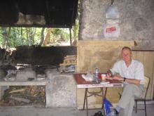
In another thread by H Lo,
In another thread by H Lo, who had added a current photograph of the ruined wall, I added my 'selfie' taken in December 2004 while sitting in the lean-to in the clearing. I found it difficult to believe that between 2004 and 2020, the lean-to had disappeared and the clearing had become so overgrown. However, I am now convinced that the wall is one and the same thing as both are described as being at the side of the clearing close to the top of the steps. The clearing has clearly become overgrown. Nature soon reclaims is own!
Perhaps my next comment might have some connection with what happened to Matheson's 'bungalow'. I don't know whether the steps on the well built staircase (unusually made out of carefully squared off granite blocks) that leads up from the catchwater beside JLO 2 to JLO1 is the same now as it was in 2003, when I took the photograph that I shall now add to my 2000 Gallery and then here. It struck me as most odd that the steps were so unusual. Any thoughts? Andrew
The steps look the same.
The steps look the same.
Don't worry, the clearing is only covered with scattered bushes and tall grass, there is still space for a tent.