Click these links to update the map above:
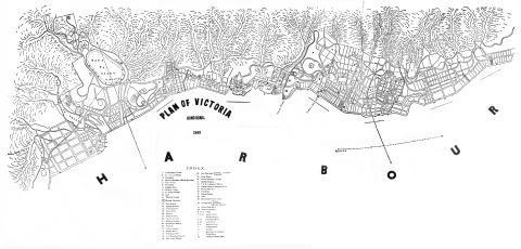
This 1866 map of Hong Kong's north shore was originally printed in the 1867 edition of The Chronicle and Directory for China, Japan, & the Philippines. Thank you to Peter Crush for compiling and sending in this digital copy.
We can compare it with the 1845 map to see how quickly the city expanded. In 1845 the built-up area stopped near Possession Point (click show me to update the map), roughly the western end of today's Hollywood Road. But by 1866 Sai Ying Pun and Shek Tong Tsui have been developed, with the built-up area extending west to the end of today's Queen's Road West (show me).
Looking east from Possession Point, and there's more expansion to see. The southern boundary in 1845 was Hollywood Road (show me), but by 1866 the city has climbed up the hillside. Several new roads have been built and the new southern boundary is Robinson Road (show me).
Despite their differences, both the 1845 and 1866 maps share something that's missing from modern maps - they show the streams that ran down the hillside. For a good example, look for the wiggly line running down the centre of this section of the map (show me). It first meets Bonham Road, then flows on downhill under Pokfulam Road, Third Street and Queen's Road before reaching the harbour at Des Voeux Road. Today the stream runs in pipes underground, hidden away from the modern mapmaker. This one has left a hint to its existence though, as today's map shows a street follows the old stream's route. Its name is just visible at the top of the map: Water Street! (show me)
There's another example over at today's Caine Road Garden, where three streams converge on a rectangular box marked "J" (show me - the map was drawn with south at the top, so the J is upside-down). The map's index shows J is "Water Tank". Though the Pokfulam Reservoir was already built by 1866, streams and wells were still an important source of water.
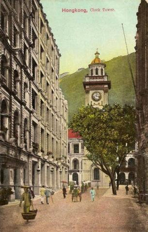
Over towards Central, a couple of small squares on the map catch my eye. They mark two gifts to the city. The first stood at the southern end of Pedder Street (show me). It's the Pedder Street Clocktower [1], built four years earlier in 1862.
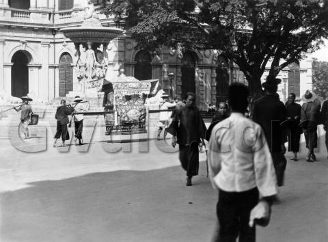
Further east along Queen's Road, we have the building marked 29, with a diamond shape below it (show me). The index lists 29 as "New City Hall: Public Fountain Opposite". The map maker was optimistic in noting the site of the City Hall [2], as it wouldn't open for another three years. The fountain was already complete though, and was known as Dent's fountain [3]. Here's a view of the fountain, with City Hall behind:
Moving east, we come to today's Admiralty district (show me). In 1866 there was only a single road, Queen's Road, for all east-west traffic across this part of the island. That was a potential bottleneck, so another road was needed. A tentative route for the new road, today's Kennedy Road, is shown on the map by dotted lines.
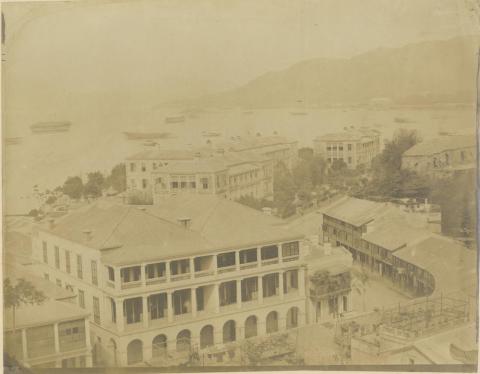
This section of Queen's Road had a couple of sharp bends, that would be notorious accident black-spots when motor cars arrived. An 1860s photos gives a clear view of the bends, and a large building beyond. The building is marked "21" on the map, described as "Military Hospital" [4].
We'll finish off at East Point, near the eastern edge of the map (show me). Item 34 is shown as "Messrs Jardine, Matheson & Co.", and item 38 as "Mint". We're lucky to catch sight of the Mint, as it was only in operation from 1866 til 1868. The Mint had been built on newly reclaimed land, and the map-maker must have believed that a much larger reclamation was planned, as his dotted lines show streets criss-crossing the bay. In fact it would remain under water for another 80 years or so, finally reclaimed in the 1950s as Victoria Park.
If you can spot any other interesting developments, please let us know in the comments below.
Regards, David
|
Also on Gwulo.com this week:
|
References:


