Current condition
Demolished / No longer exists
Early maps show the main building as a 'Military Hospital', then on later maps it is described as 'Wellington Barracks'. I believe it took its name from the Wellington Battery, which was built on the shoreline just to the North of this site.
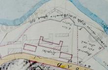
- 1856: Shown on map [1] as 'Military Hospital'.
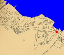
- 1889: Shown on map [2] as 'Military Hospital'.
- 1930: Shown on map [3] as 'Wellington Barracks'
- Today: Part of Harcourt Garden covers this site.
The Maps referenced here come from the 'Mapping Hong Kong' book:
- [1] Plate 3-1c (1856) Plan of Victoria
- [2] Plate 3-2 (1889) The City of Victoria
- [3] Plate 3-5a (1930-45) 1:10,000 map sheet Victoria GSGS3890
Photos that show this Place
1845
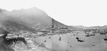
1856
1860
Comments
Main Building - Military Hospital
Looking at maps at https://www.hkmaps.hk/viewer.html , I note the name "Wellington Barracks" appears on the 1901.3 map of Victoria next to the main building. Appears a major change took place around the late 1890s (?) in the use of military facilities on the northern side of Queen's Road.
I found the following description of the Military Hospital in the Report of Committees on the Mortality of Troops (China) from 1866 :
"The Military Hospital at Hong Kong consists of a centre building and two wings, placed at right angles to the main building, in each of which there are quarters for medical officers. All the buildings are furnished with suitable verandahs on all sides. There are detached outbuildings including kitchens, wash-houses etc, which are all in good repair.
The main buildings are of three storeys; the lowest or basement is appropriated as stores, surgery, purveyor's office etc., but as it is very damp, and records are soon injured or destroyed, it seems to me (the Principal Medical Officer) unsuitable for any office. The two upper storeys only are occupied as wards, and there are 13 in all, the aggregate capacity of which amounts to 200,877 cubic feet, and thus affords regulation space for 127 sick."
Other References:
Victoria Barracks (Hong Kong) 1842-1979. Edited by Lieutenant Colonel D.H. Oxley. See https://wellcomecollection.org/works/aucegxee/items
WELLINGTON BARRACKS
1. Introduction
I recently posted this photo showing the Three-storey building on Queen's Road at eastern edge of Wellington Barracks [????-????]:
The caption attached to the photo at the exhibition "Faces and Places" shown in 2009 (see here) reads:
Queensway in 1980. The old building one the right (named Rodney House after the Second World War) was used as a hospital in the 19th century and might be the original "D'Aguilar's Hospital" built in the late 1840s. It was a typical building of colonial style, built of granite, bricks, concrete and timber. The pitched roof and verandah were local adaptations to the subtropical climate of Hong Kong.
This is incorrect as Herostratus pointed out:
The building on the right was actually named Blake Block. It had a sister building that would have been on the far left of the photo named Howe but Howe was demolished in the mid-1970s to straighten the kink out of Queensway. These were part of the original Wellington Barracks buildings built in the mid-1840s. Blake building survived until the early 1980s when it was demolished to build the approach flyover to Pacific Place. The building named Rodney was the large central building - at some point in the 1960s the original 1840s building was demolished and a new building was constructed, known as the New Rodney building, which can be seen the picture behind to the left of Blake Block . This was also demolished in the 1980s as part of the redevelopment of the area.
2. History of the three original buildings
As mentioned before, the three buildings of Wellington Barracks were built in the early 1840s. To make it easier for the viewer, the buildings are named using their post-WW2 names: Howe (west), Rodney (centre), and Blake (east). They all can be seen on the 1845 map on Gwulo:
On the 1856 map, the western building (Howe) is labelled “Engineers”, the central one (Rodney) “Military Hospital”, and the eastern one (Blake) “Medical”.
These three buildings are present on this photo from c.1870
and 1907
On both photos another building just east of the eastern building (Blake) can be seen. It was likely added in the second half of the 1800s and was part of the Arsenal Yard. It was removed later and is missing on this photo from 1946.
The western building (Howe) is hidden behind other houses at the southern side of Queensway.
Another good view from 1961 is here:
3. Demolition and rebuilding of the central building (Hospital/Rodney Block/New Rodney Building)
The predecessor of the central building (likely Rodney Block) was demolished likely in 1964, it was still there on an aerial photograph from February 1963. The first appearance of the New Rodney Building on a photo is from 1965 when it was still under construction:
Moddsey referred: Completed in the financial year 1965/66 as mentioned here in the Annual Department Report by the Director of Public Works. Very likely 1965 as the year of completion based on the previous year's Annual Report.
The building survived all its neighbours, it was finally demolished in 1991 (appeared on an aerial photo from November 1990, gone on one from October 1991
4. Western building (Howe Block)
The western building (Howe Block) was demolished around 1972 for the straightening of Queensway, it does not appear on the 1973 map on hkmaps.hk. The two others were still there in 1977:
5. Eastern building (Blake Block)
The eastern building (Blake Block) was demolished 1981 or 1982, it is gone on an aerial photograph from 1982 (hkmaps.hk).
Here is a photo from 1987 with only the New Rodney Building:
As mentioned above, it was demolished in 1991.
6. Harcourt Garden
On the place of the Wellington/Tamar Barracks, Harcourt Garden opened in 1994 (couldn't find an official opening date, on an aerial photo from May 1994 it looks quite finished).
Good Work
Good work. A suggestion - as time goes on with more photos being posted, perhaps there is a need to create a separate place location for Howe Block and/or rationalise the names of the three main buildings in Wellington Barracks. Cheers!