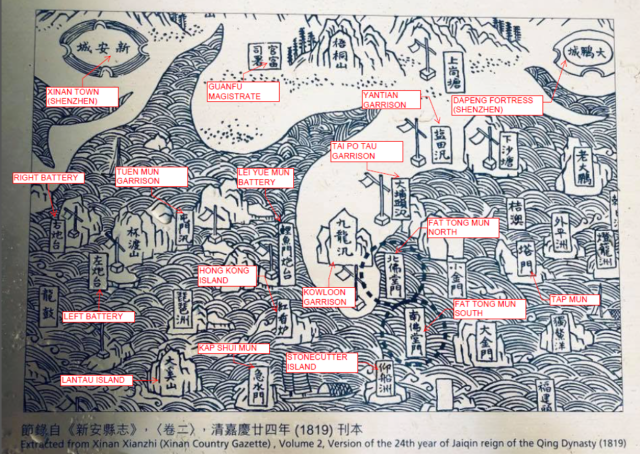
Map of Coastal Defense in the Xin'an County Gazetteer《新安縣志海防圖》, 1819 (the 24th year of the Jiaqing Emperor's reign嘉慶二十四年)
This county map, compiled by Shu Maoguan 舒懋官 and others, employs the traditional Chinese "landscape map" style. Although not a modern scale map, it holds immense historical and strategic significance. Its core features include:
• Coastal Defense Layout: Detailed markings of Qing Dynasty coastal islands, garrisons, forts, and military strongholds, such as "Xin'an City", "Dapeng City," and the coastal defense line.
• "Red Incense Burner" Marker: The map features "Red Incense Burner" in the center, a place name considered by many scholars to be an early name for the area of present-day Hong Kong Island or Causeway Bay.
Kat O and Ping Chau (外平洲) are also mentioned in the old map.. I also suspect the 'Ying Pun' village in present day Tai Po Tau may have something to do with the 'Tai Po Tau Garrison' mentioned.
營盤literally means where you 'garrison' your armed forces. There are other villages called Ying Pun though. There is one along Lam Kam Highway.
"Outer Ping Chau外平洲" refers to Tung Ping Chau 东平洲 (originally named Ping Chau), located in Mirs Bay to the northeast of present-day Hong Kong.
============
吉澳(Kat O or Crooked Island)
It is an island located in the northeastern part of the North District in Hong Kong's New Territories, with an area of 2.35 square kilometers; it lies within the Double Island Special Area. Currently, fewer than 50 people reside there, most of whom are elderly.
In the past, the island was planted extensively with tangerine trees; every winter, it was covered with golden tangerines.
===========
The *Gazetteer of Xin'an County* (compiled in 1819, the 24th year of the Jiaqing reign) provides detailed records regarding the distribution of military installations in the Hong Kong area within Volume 8 ("Military and Penal Affairs") and Volume 2 ("Maps and Geography"):
Coastal Defense Infrastructure:
The Qing government established a defense network across Xin'an County (comprising present-day Shenzhen and Hong Kong) by centering operations on Dapeng Fortress 大鵬所城 and Nantou City南頭城—serving as the eastern and western hubs—and extensively deploying signal towers墩台, military encampments營盤, outposts汛房, and artillery batteries炮台.
Comments
Map of Coastal Defense in the Xin'an County 1819
Map of Coastal Defense in the Xin'an County Gazetteer《新安縣志海防圖》, 1819 (the 24th year of the Jiaqing Emperor's reign嘉慶二十四年)
This county map, compiled by Shu Maoguan 舒懋官 and others, employs the traditional Chinese "landscape map" style. Although not a modern scale map, it holds immense historical and strategic significance. Its core features include:
• Coastal Defense Layout: Detailed markings of Qing Dynasty coastal islands, garrisons, forts, and military strongholds, such as "Xin'an City", "Dapeng City," and the coastal defense line.
• "Red Incense Burner" Marker: The map features "Red Incense Burner" in the center, a place name considered by many scholars to be an early name for the area of present-day Hong Kong Island or Causeway Bay.
Map Marker in English are:-
HONG KONG ISLAND
KOWLOON GARRISON
STONECUTTER ISLAND
KAP SHUI MUN
LEI YUE MUN BATTERY
TAI PO TAU GARRISON
FAT TONG MUN NORTH
FAT TONG MUN SOUTH
TAP MUN
TUEN MUN GARRISON
LANTAU ISLAND
GUANFU MAGISTRATE (SHENZHEN)
XINAN TOWN (SHENZHEN)
DAPENG FORTRESS (SHENZHEN)
YANTIAN GARRISON (SHENZHEN)
RIGHT & LEFT BATTERY (SHENZHEN)
Re: Not Quite
Hi there,
I believe both left & right battery were in Shenzhen, Chi Wan (赤灣).
T
Thanks T
u r correct, will amend it w thx
Re: There is also Kat O
Hi There,
Kat O and Ping Chau (外平洲) are also mentioned in the old map.. I also suspect the 'Ying Pun' village in present day Tai Po Tau may have something to do with the 'Tai Po Tau Garrison' mentioned.
營盤literally means where you 'garrison' your armed forces. There are other villages called Ying Pun though. There is one along Lam Kam Highway.
T
Kat O 吉澳 and Ping Chau 外平洲 and Yin Pun 營盤
"Outer Ping Chau外平洲" refers to Tung Ping Chau 东平洲 (originally named Ping Chau), located in Mirs Bay to the northeast of present-day Hong Kong.
============
吉澳(Kat O or Crooked Island)
It is an island located in the northeastern part of the North District in Hong Kong's New Territories, with an area of 2.35 square kilometers; it lies within the Double Island Special Area. Currently, fewer than 50 people reside there, most of whom are elderly.
In the past, the island was planted extensively with tangerine trees; every winter, it was covered with golden tangerines.
===========
The *Gazetteer of Xin'an County* (compiled in 1819, the 24th year of the Jiaqing reign) provides detailed records regarding the distribution of military installations in the Hong Kong area within Volume 8 ("Military and Penal Affairs") and Volume 2 ("Maps and Geography"):
Coastal Defense Infrastructure:
The Qing government established a defense network across Xin'an County (comprising present-day Shenzhen and Hong Kong) by centering operations on Dapeng Fortress 大鵬所城 and Nantou City南頭城—serving as the eastern and western hubs—and extensively deploying signal towers墩台, military encampments營盤, outposts汛房, and artillery batteries炮台.