This image came from Flickr, see: https://www.flickr.com/photos/chethams_library/14436015805/
Photos acquired by Sir Bosdin Thomas Leech and Lady Leech of Manchester, during their round-the-world trip in 1901.
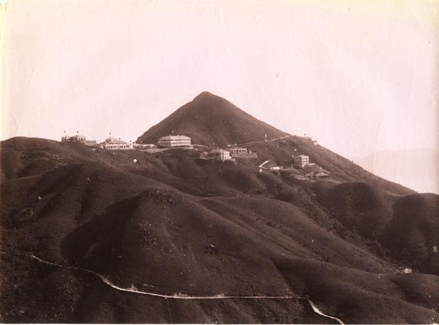
It looks like they bought commercial photographs during their visit. From other photos in this collection, the date can be estimated to c.1895–1900.
I have annotated the photo for easier identification. I started the identification, but I'm not sure, and some houses are unknown to me. Please help.
A
B
C Des Voeux Villas 1-7, RBL 53 [????-????] | Gwulo
D „
E „
F „
G „
H
I Cameron Villas - RBL 35 - RBL 556 [????- ] | Gwulo
K „
L Kellett Lodge [????-????] | Gwulo
M No.4 Cameron Villas, Mount Kellett [????-????] | Gwulo
N
The road in the foreground should be Pokfulam Reservoir Road.
Note: this is the original photo used for this postcard.
Comments
Mount Kellett Houses
Hi Klaus,
Thanks for posting this very clear photo. I found the following photo very useful when attempting to identify the buildings.
I reckon;
A + B. Both Myrtle Bank.
C + D. Both Des Voeux Villas.
E. Wageningen and The Retreat (semi-detached houses).
F. The block of Des Voeux Villas facing east, i.e. the building in the bottom right corner of Annelisec's pic above.
G. Perhaps another block of Des Voeux Villas or Eilendonan, but I'm really unsure about this one.
H. Rockyda, but again I'm far from confident.
I + K. One of the houses of Cameron Villas.
L. Yalta, which was later renamed or rebuilt as Kellett Lodge.
M + N. More of the houses of Cameron Villas.
I haven't yet worked out the individual house numbers for all the Cameron Villas buildings Different sources seem to contradict each other. More research needed.
Thank you gw for adding…
Thank you gw for adding places. For a possibly better identification, I've cropped the Mt. Kellett part from a 1909 map on Gwulo. The map was published in 1909 and is likely based on a survey made some years earlier (but likely not in the year when the photo was taken). This could mean that not all the houses on the map are already in the photo, but it is a good start.
Here's an experiment to…
Here's an experiment to locate the buildings in both the c.1895 photo and the 1909 map.
I'm not really convinced especially with the Cameron Villas: I expected the larger building on the right to be No. 4 Cameron Villa, but in this constellation it would be No. 1 Cameron Villa.
Any better solutions are welcome.
By putting the map and photo…
By putting the map and photo above together, with the map from hkmaps ("1922" and/or "1950"), more features can be compared. It looks like the identification of the houses are reasonable.
Numbering of the villas
I think that we have identified the buildings on the photos. However, regarding Cameron Villas, which is the correct numbering? Let's start with the peak renumbering post by Herostatus:
What do we know?
The "The Commissioner's House, Mount Kellett" certainly is the building labeled "M" (in my annotation) or "C1" (in TN Kwok's annotation). The early maps (e.g. 1909) indicate that this would be No. 1 Cameron Villa at 60 The Peak.
Some clues tell us that this should be No. 4 Cameron Villa. How can this be solved?
Recently, gw posted this 1950s map:
He was quite sure that 178 is No. 4 Cameron Villa. Referring to the table in this post, it is confirmed.
But it still puzzles me that older maps indicate that this was No. 1 Cameron Villa.
some more from Street Index 1938
Thank you for listing the details.
In “Street Index 1938”, similar information can be found as the peak number post, with some more details of R.B.L. numbering:
- 175 (61) R.B.L. 402 & G.L. 95 “Cameron Villas” No.1
The other houses of Cameron Villas No.2-6 are on sections of R.B.L. 35, with extra details of a “tennis lawn” and “garage”:
- 178 (64) R.B.L. 35 s.A R.P. “Cameron Villas” No. 4
- 178 (64) s.A ss. 1 Garage
- 178 (64) s.F. Tennis lawn adjoining No. 177
These added some details as those in the 1950s Map of Mount Kellett (Survey & Mapping Office, their ref: HG36).
But it remains a question that why maps, 1909 map or 1950s Map, are showing different labels of No. 1 and 4.