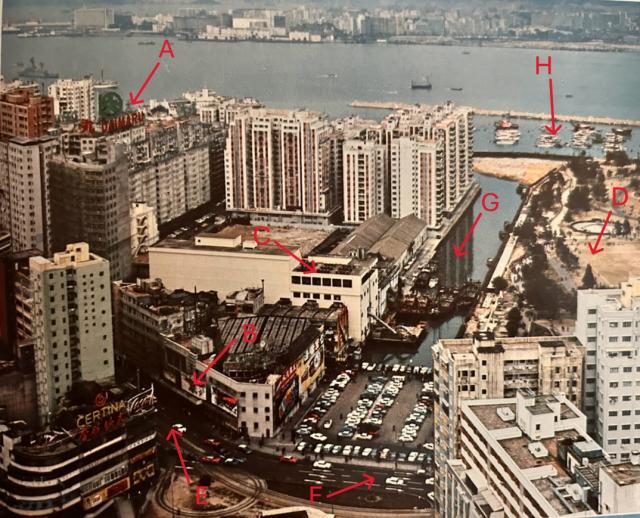
This is another photo from the Dairy Farm 1967 Annual Report. This photo shows the East Point ice-making plant operated under the Dairy Farm Refrigerated Trading Division. Dairy Farm started to get involved in the ice-making business in 1918 when it acquired the business of Hong Kong Ice Company. As a result, Dairy Farm’s official name was changed to Dairy Farm Ice and Cold Storage Company Limited. By 1967, Dairy Farm had five ice-making plants, and they were located at Castle Peak, Chekiang Street, and Kun Tong in Kowloon and Aberdeen and East Point on Hong Kong Island. I am surprised that the annual report still calls this location “East Point”. By 1967, this area was commonly known as Causeway Bay. There is a canal allowing the ice from the ice-making plant to be transported by boat. In 1968, a crossover (across the canal) and a conveyor were built, allowing the ice to be transferred to a loading dock at the typhoon shelter instead of at the canal.
I still remember ice making was still popular in the sixties in Hong Kong as the demands were still there. Though in Hong Kong island and in Kowloon, convenience stores all had electric ice water chests to store the soft drinks, this was not the case in the New Territories and the surrounding islands. Convenience store owners still had to buy chunks of ice and put them in the ice chest to keep the soft drinks cold.
A: Daimaru Department Store
B: Old Roxy Theatre (closed in 1974 and redeveloped as high rises)
C: Dairy Farm East Point ice-making plant
D: Victoria Park
E: Yee Wo Street
F: Causeway Road.
G: East Point Canal
H: Causeway Bay Typhoon Shelter
Comments
Re: Ice conveyor system
Hi There,
I believe the covered conveyor system is already under construction in the photo above. See the bright straight stripe along the 'canal' there.
T
Ice Conveyor System and the Circular Tram Loop
Thank you for bringing this to my attention. I did not pay enough attention to the fact that the silver rectangular-shaped line structure along the canal was actually part of the conveyor system. I only focus on the crossover section of the conveyor spanning from the ice-making plant, across the canal to the other side. When the photo was taken, it appeared that this section of the conveyor system had not been built yet. Thanks for bringing this to my attention.
After rechecking the photo, I would like to bring out another interesting facet that has nothing to do with Dairy Farm but is related to the Hong Kong tram track system. In the bottom of the photo, in addition to the two parallel tram tracks from Yee Wo Street to Causeway Road, there is also a circular tram track looping from the eastbound track back to the westbound track. This tram track loop is for the Causeway Bay tram to make a return to go westbound back to the Western Market in Sheung Wan after reaching its last stop.
Even though the Hong Kong tram track spans all the way from Kennedy Town to Shau Ki Wan, the tram ride comes in overlapping sections. One section of the tram ride is from Western Market in Sheung Wan to Causeway Bay. The last stop for this eastbound ride is just outside Roxy Theater which is shown in the photo as item B. Back in the sixties, after everyone was off the tram, a track operator would switch the track so the Causeway Bay tram would move along the loop track and return to the regular westbound track. The tram driver would then switch the tram label to “Western Market”. On its first stop, which is also across the street from the Roxy Theater, the tram would pick up passengers for the westbound ride back to Sheung Wan.
Additional Photos of Dairy Farm East Point Ice-Making Plant
Re: a bit more info about the photo
Hi there,
In the photo just a bit higher than the marker 'C', there is a boundary wall (greyish in colour) running from Paterson Street towards the Canal. The wall is still there today. It runs the full length of Kingston Street, at the back of Kingston Mansion (blocks A & B), Vancouver Mansion, & Greenfield Mansion.
T
Thank you for your comment.
Thank you for bringing this up. This area of Causeway Bay was completely rebuilt and is almost unrecognizable from all the old landmarks such as the canal, the Roxy Theatre, and the Hoover Theatre. The only reminisces of the sixties are just the tram tracks and the status of Queen Victoria at the entrance to Victoria Park.
Re: Boundary wall
Hi There,
There is actually another boundary wall running from Great George Street straight to Gloucester Road, which still exist. Some sections of it may have been removed during the construction of One Causeway Bay. I will update when the works are completed.
T
Thanks for the additional info
I wonder if you have any info or knowledge about the purpose of these boundary walls. They must have served some foundation purpose, so the builders decided to keep them instead of demolishing them.
Re: Boundary Walls
Hi there,
I don't have further info about them. I grew up in the area since the 1960s. Those walls had been there as far as I could recall.
T
Re: Boundary walls
Hi There,
I have found yet another boundary wall just west of World Trade Centre. Now I have a theory. Those walls were likely being erected when sites around the Jardine East Point location were being redeveloped into residential highrises. At the time when the redevelopment started, JM was still running their godowns at Eastpoint.
The photo at the top of this thread showed a cleared out area on the side of Paterson Street, while on the Canal side, there are tiled roof buildings, likely of industrial\business origins.
I also had a walk around Paterson Street. The wall from #51 towards Gloucester Road had been demolished, hence the boarding up of the whole section there. The security guard\care taker of #51 confirmed the demolition and complained about Gammon (JM's building arm, contractor of CWB One) would be building a new wall later. However it would be taking a little bit of land on the Paterson Street's side. This is yet to be confirmed and had to wait till the work is done in due course.
T
Jardine Godowns in the East Point
Thank you for arousing my interest in the Jardine Matheson Godowns at East Point. I was able to dig out some of the Gwulo nodes showing the map and photo of the early East Point. I wonder if these maps and early photos might help to confirm that these walls were the boundary walls of the Jardine Godowns. I still remember the beautiful stone wall and gate entrance to the Jardine Godowns. When I was young, I got the wrong impression that the Jardine Godowns were in Wanchai. Maybe, my father was driving along Gloucester Road from Wanchai and I did not realize that it spans all the way to Causeway Bay.
https://gwulo.com/media/43966
https://gwulo.com/media/37205 (1945)
https://gwulo.com/media/47996/zoom (1958)
https://gwulo.com/media/17660 (photo of the East Point area before high rises were built)
https://gwulo.com/media/43881 (photo of the godowns entrance gate)
Map of Jardine Godowns in the East Point
from https://www.hkmaps.hk/map.html?1958.1
Map of Jardine Godowns in the East Point
From https://www.hkmaps.hk/map.html?1962.1
Map of Jardine Godowns in the East Point
From https://www.hkmaps.hk/map.html?1965.1