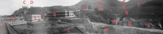
Annotated copy of https://gwulo.com/media/28538
The panorama is created by merging three photos from the Swire Collection, see https://www.hpcbristol.net/visual/sw05-128, https://www.hpcbristol.net/visual/sw05-129 and https://www.hpcbristol.net/visual/sw05-130
Points of interest identified by Geoff Wellstead:
- A -
- B -
- C - Kornhill West
- D - Kornhill East
- E - The Taikoo Club, with bowling green in front and playing fields below
- F -
- G - This may have been what oldtimers in the 50s referred to as "the old Taikoo Terrace", with a tennis court at the end which was still in use in the 50s (mainly by me and my friends)
- H, I, & J - Stanley Terrace. (H was known as 'Bottom terrace', I as 'Middle Terrace', and J as 'Upper or Top terrace'.)
- K - The Bungalow
- L -
- M -
- Between M & N - It looks like the Kings Road cutting is under construction
- N, O, and P - Tai Koo Sugar staff housing
- Q -
- R - The pylons & cables of the Taikoo Ropeway
- S - Woodside
- T - Tai Koo Sanitarium
Date picture taken
1924
Gallery
Shows place(s)
Comments
Quarry Bay Village
Buildings marked N O and P comprise the local staff quarters of mainly Sugar Refinery staff. There was a "compradore" mixed business at the northern end of middle block O, where Geoff Wellstead and Dick Halliday typed up the first edition (of three) of a student newspaper grandly titled Hong Kong Herald, which sold at KGV for 10 cents.
These buildings were loosely modelled on those of dockyard workers on the Clyde.
re: Quarry Bay Village
Thanks Geoff, I've updated the list above.