This used to run from the Quarry Bay area at the bottom of the hill, up the valley to Quarry Gap.
When the ropeway (another name for 'cable-car') was running, Quarry Bay held the Taikoo Dockyard and Taikoo Sugar Refinery, while Quarry Gap was known as Sanitarium Gap, and was the site of the Taikoo Sanitarium.
When did it run?
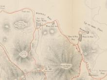
But when did the ropeway run? The 'Mapping Hong Kong' book shows the 'Tai-Koo Sanitarium' on plate 7-1, a tourist guide map from 1896. It also mentions the building in one of the guide's suggested sight-seeing routes:
PROGRAMME No. 7
Proceed by ricksha to Bay View [a building that stood near where Tin Hau MTR is today], as the road is too long and uninteresting up to this point; thence walk to Quarry Bay, where, after having passed the entrance to the Sugar Refinery, about one hundred yards further on, just before crossing a bridge, you will see on your right hand, the pathway up the hill [the pathway is today's Mount Parker Road]. Something under one hour should bring you to the top, which is only a gap about feet 1,000 [sic.] above sea level. Here are the Sanatorium buildings of the Taikooo Sugar Refinery, Messrs. Butterfield & Swire. [The walk continues down to Ty Tam reservoir, up to Wongnai Chung Road, then down to Happy Valley, where 'we can obtain a ricksha to convey us to town.']
That same map shows a dotted line that runs from near the 'Tai-koo Sugar works' up to the Sanitarium. I wonder if this was already the cable car in place?
Plate 2-12 in the same book is a wartime map, dated 1939-40, and overprinted with Japanese. It shows the 'TaiKoo Sanitarium' building, connected to the 'Sugar Refinery' by an 'Aerial Ropeway', so it was in use then.
Plate 2-13 is a 1949 map. It still shows a dotted line along the course of the ropeway, and the outline of the sanatorium building is there too. Neither are labelled though, and the Gap is now labelled 'Quarry Gap'. So, perhaps the building and the ropeway were damaged during the war, and were never repaired afterwards?
What did it look like?
The ropeway can be seen in several photos from the G. Warren Swire collection (click the thumbnail to see a larger view of the photo):
- In the bottom of this photo, you can see one of the white towers that supported the ropeway.
- Here's a better view, showing the towers running up the valley.
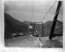
- And here's the view from the top looking down the valley. The concrete platform on the right was likely the place for loading and unloading.
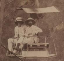
Reader IDJ has sent in this photo of a cable car at the loading bay:

Are there any remains?
We've also been sent the following notes and photograph by Rob Weir, suggesting that some signs of the ropeway remain:
Some time ago, when I was scouring the side of the Mt Parker/Quarry Gap area looking for PB 45, I noticed two small squares marked on one map . Although they didn't appear to be anywhere near the expected PB area, I can never ignore something apparently man-made. Having fought my way down from Mt Parker Road through some distinctly unfriendly vegetation, I eventually bumped into them.

They seem to be the base of one of the stanchions for the ropeway to the Sanatorium/Sanatarium. Why these two should be marked, I have no idea
Please leave a comment below if you can help provide any more information about this.
Regards, David
Photos that show this Place
Comments
Re: Taikoo Ropeway
Plate 2-5 dated 1895 from the Mapping Hong Kong book also shows the aerial ropeway (which is identified, however, as an overhead tram) running from Quarry Gap to a position near the Taikoo Sugar Refinery.
As the ropeway was run by a private company, not much information is available through the public archives. However, the only item that is worth sharing is that an entry has been made for 1904 that the cable car route of the Mount Parker Tramway was doubled-lined that year. Cheers.
Re: Taikoo Ropeway
Thanks Moddsey, I hadn't noticed it shown on that other map.
Here's the quote Moddsey mentioned, taken from the Report of the Director of Public Works, for the year 1904:
Duplication of the Mount Parker Tramway
This cable car route at the Tai Koo Sugar Refinery has been doubled during the year.
That led to this quote from the 'Nature Touch' website:
In 1881, Taikoo Sugar Company acquired land along the coast of Quarry Bay to develop the Taikoo Sugar Factory. Since the company built staff quarters in the Mount Parker area, to facilitate movement, it also developed Hong Kong's first ever cable car system in 1892.
C. M. Guildford's summary of Civil engineering in Hong Kong also gives it a couple of mentions. First he guesses it may have been related to the Tai Tam reservoir:
On an uncontoured 1895 version of Collinson's plan (1845), there
is an interesting feature clearly marked "overhead tram" extending 2.3
kilometres between Quarry Bay and Quarry Gap. It seems likely that it
would have been used to transport materials and, perhaps, workmen
associated with the early Tai Tarn reservoir works.
But in an addendum he adds the following correction:
Since this article was first published, a reader has kindly advised
that the purpose of the "overhead tram" referred to in the section on
Water Supply was not as suggested but to provide access to two blocks
of flats used in the summer by the Tai Koo sugar refinery staff. It was
probably erected in 1891 and survived until 1932 when both the flats
and cableway were dismantled.
I walked up to Quarry Gap yesterday. On the north side of the gap, just below the ridge, is a small flat, grassy area. I wondered if there is still any sign of the cablecar platform shown in the photos above. There is a small section of bricks and concrete in about the right place, but nothing I could see that would prove what it was built for.
Memories of the Taikoo Ropeway
This from Dick Worrall:
I remember the foundations of the buildings in the gap (some are still there) as well as the mounts for the pylons. I even used to know a man (former Taikoo Dockyard Manager called Bell) who had travelled up and down the cable car when he was a lad. They were never referred to as a sanitorium in my day but spoken of as accomodation to which the Taikoo families would go up to for the summer months.
Dick was born & raised in Quarry Bay, and is the son of the last Master of the Taikoo tug. Thanks to Dick for his comments, and to Guy for the introduction.
Regards, David
Re: Taikoo Ropeway
Follow-up comments from Dick:
You call it the ropeway, my old man always called it the "cable car". I also remember (down at the "Woodside" (Taikoo Sugar's Manager's House)/Quarry Bay end) some of the metal supports for the cable as being much more substantial that the ones shown in the photographs - possibly because the "drop" in that area was quite sheer as it ran alongside the Taikoo Sugar Refinery's reservoir which was at the entrance to the valley.
Dick's right, 'Cable car' is the usual way to describe it these days. 'Ropeway' is the word that appears on the old maps, and I guess is the old-fashioned way to describe it, along with railway, tramway, etc. 'Ropeway' is still used in some formal documents, eg Hong Kong has an 'Aerial Ropeways (Safety) Ordinance'.
Abandoned railways in Hong Kong
Dear David,
I discovered your website completely by chance and it would be an understatement to say that I am thrilled by what I can see.
I have been, for some years now, conducting research into abandoned railways in Hong Kong (and some other cities in China, eg Peking), and this includes proposed projects that were never materialised. I have almost exhausted the collection held by Public Records Office and the Lands Department, and apparently what excites me about this website is that you seem to have access to a different set of resources that I never knew existed. I have, for example, never heard of the Queensway cable car, although I have heard of the railway systems in the Admiralty magazine and Whitfield Barracks in Kowloon. The Public Records Office was more helpful in matters such as the Wo Hop Shek railway, but on military and private (eg Whampoa, Kai Tak, Morrison Hill) systems, and on railways already disused before the war (eg the Sha Tau Kok branch line) it is completely hopeless.
I am looking for photographs of the Baker Street link between the Hung Hom depot and the Whampoa railways. It crossed Chatham Road North so certainly would be present in photographs of the area. I wonder if one exists in your collection?
If you are interested, I can send you two articles that I have written so far, one on the Wo Hop Shek Railway and the other on the Mount Parker Ropeway. They were written some years ago and were planned to become eventually part of a book that would cover all disused railways in the city. Upon rethink I now believe a book on the history of railway planning would be of more interest to the general public (and the publishers!).
I am interested in all things about old Hong Kong, it just happens that I am attracted to railways (and colonial politics) more than anything else!
Best regards
Ernest Leung
re: Abandoned railways in Hong Kong
Hello Ernest,
You mention several railways I've never heard of, so I hope you'll share more with us over time. And yes, I'd be very interested to read your articles - my email address is:
. (I'm sure other readers will be interested to see them too, so if you're willing to publish some or all of their content here, that will be even better.)
Here's a conversation we had about the Baker street link back in April. Moddsey found the text dating when the link was built (Nov. 1937), but we're not sure when it went out of service, and have yet to find any photographs of it.
Thanks for getting in touch,
David
Photos of the Taikoo Ropeway
Thanks to Geoff Douglas for pointing out these two photos, one showing the lower station of the ropeway, and one showing the Sanitarium / Summer Flats up at the gap: http://www.facebook.com/photo.php?fbid=3064690174788&set=o.21271626725&…
Regards, David
Bertie Bell
Dear David
Im trying to find out more information on Bertie Bell (Robert Barr Bell) ...
[Admin, I've moved this question to a page for Bertie Bell.]
The Taikoo ropeway
It got a mention in this 1914 article:
Thanks to IDJ for the link,
Regards, David
Taikoo Ropeway
I was up at Quarry Gap last weekend and noticed some possible remnants of the old Taikoo Ropeway. They may be the ones mentioned by Dick Worrall in David’s post of 30-8-2009.
On the northern side of the Gap are newish public toilets. Behind them, i.e. on the Quarry Bay side, the land drops steeply to a flat seating & play area. Just to the west of the toilets a large "indentation" seems to have been cut into the contour at the top of the slope. From the mouth of the indentation a steep "ramp" runs down to the seating/play area. The slope and "ramp" have been “shot-creted” in recent years, covering most of the features beneath, but older concrete and metal structures poke through the concrete on the margins of the “ramp”.
I'm thinking that the "indentation" and "ramp" may represent the old "docking bay" for the cable cars at the upper terminus of the Taikoo Ropeway, i.e. the space the cable cars slide into where passengers embark and alight at the sides onto concrete platforms and steps, some of which are still there. The first photo in David’s post on the Ropeway, dated 25-8-2009, clearly shows that a docking bay existed.
An indicator that this may not be the docking bay is the width of the “indentation” which measures about 14 to 15 feet across, which is surely much wider than the docking station in the photo and much wider than would be necessary to house one of the relatively narrow cable cars seen.
David’s post of 27-8-2009 mentions that the tramway was “doubled” in 1904. I’m not sure what that term means, but wonder if it could have led to bigger, i.e. wider, cable cars being used, necessitating the widening of the original docking bay?
Arguments “for” it being the old docking bay are that it’s in roughly the correct position, of generally the expected shape and faces the correct way. Also, if it’s not the old docking station, then what is it?
re:Taikoo Ropeway
GW,
Thanks for posting. I agree the slope and walls look like they belonged to the ropeway. I'm not sure exactly what the connection was though - I'm still hoping some more old photos will turn up and show us more views of what the top of the ropeway looked like.
Regards, David
Winding gear
After I posted this photo of the Sanitarium:
GW commented:
In the Taikoo Sanatorium pic a building can be seen behind and slightly above the Sanatorium. It's roughly where the Upper Terminus of the Taikoo Ropeway was situated. There's an object that looks like a large, dark, vertical wheel. I wonder if it was part of the winding gear for the cable car?
I contacted Swire' Archives to see if we could get more detail, and Matthew and Angel kindly helped supply this:
It certainly looks like cables and wheels that could be part of the winding gear. The only point against that is that my limited experience of cable cars (Ocean Park!) has the car go around the winding wheel, which wouldn't be possible with the setup in this photo. Perhaps it was a simpler arrangement where the cars were pulled up and let back along the same path, without ever going round the top - something like how the Peak Tram works.
As a bonus, the Archive also sent these two extra photos:
Taikoo Ropeway
David,
Thanks for following up on my comment. The two extra photos are a nice reward for your work.
On the basis that I can't think of anything else in that location that would need such wheels and cables, apart from the Ropeway, I'm confident that they're part of the winding gear for the Ropeway.
The upper of the two new photos bears the inscription, "Refinery Man-tramway Top View" and is dated "? Sept 1892". Your post of 27-8-2009 above says the Ropeway was constructed in 1891 or 2. Below the second metal frame from the top, two men are standing on rickerty looking platforms. The later photo at www.gwulo.com/media/12556 shows what seem to be concrete platforms at either side of the upper terminus. As the new photo was taken around the time the Ropeway was constructed, and the platforms have an unfinished look about them, perhaps the Ropeway was still under construction in September 1892 and opened shortly afterwards.
Taikoo ropeway
Zooming right in on the cable car shows the supporting wheeled trolley just sitting on the cable presumably held in place by gravity and the weight on the cable car.
Another cable/rope appears to be the means of pulling the cable car and between the supports is a vee-shaped metal structure to guide and support the pulling rope when slack. The wheel referred to by GW is probably supporting the pulling cable as it enters the machine room winding the rope up. The car would be pulled up, but sent down by gravity controlled by the rope.
The cable on the left of the support structure could be the telephone cable for communications between those operating the driving/pulling/slackening mechanism
The picture I posted some time earlier of a cable car arriving at a concrete terminus shows a more sophisticated double cable supportsystem.
Re-reading the article in a 100-year railway old book on the Taikoo system, it appears to infer the passenger/freight car is double ended so people would be sat back to back.
Similar basic systems to the original Taikoo installation could be seen in China and Burma to cross rivers and deep valleys and no doubt are still in use today.
I would expect the Taikoo system to have been written about in contemporary issues of the UK based magazines ‘The Engineer’ or ‘Engineering’ that covered new installations by British manufacturers overseas
Also see http://industrialhistoryhk.org/bullivant-supplier-taikoo-sugar-refinery…
Taikoo Ropeway
Mention of the Taikoo Aerial Ropeway at Quarry Gap from a visitor to Hong Kong. HK Daily Press 6 August 1895 refers.
"At Taikoo about 5 miles from Victoria, there is an aerial flight, the like of which can seldom be seen. There is one in Gibraltar that goes up to the top of the Rock, but the ride there bears no comparison to the sensational transition from the base to the top of Mount Parker at Hong Kong. It would be a misnomer to call it a railway, because the open car does not run on rails, but is suspended and as you soar upward, now crossing over the top of a minor peak, next looking down on a lake some hundred feet below, or onto a gorge, espying perhaps now and then a wild deer or other smaller animal, the first ride up and down is an experience not soon to be forgotten. This aerial flight was constucted evidently at considerable cost by Messrs Butterfield and Swire of the Taikoo Sugar Refinery, to convey their European staff to the dormitories to the top of the mount at the heght of summer when the nights are so oppresivly hot when sleep is out of the question in the houses below. Before the aerial flight was constructed, the emplyees referred to were taken up the mountain in chairs by a small regiment of coolies, the expenses being borne by the firm. Then, it took them an hour to reach the cool atmosphere at the top; now they can go up in five minutes. As the car is ascending, the man in the engine house watches it as far as he can through a telescope, and at the point where his view is obscured by the top of a peak, another man half-way up continues the watch. Should anything wrong be observed, the car can be instantly stopped." -- Kobe Chronicle.
Remnants of Swire Ropeway
Dear Friends,
From the given image of the Swire ropeway. Did anyone take a note of the Slope Registration Number? Can someone be helpful to identify the number?
Link attached http://hkss.cedd.gov.hk/hkss/eng/sis_map.aspx
I look forward to hearing from you soon.
Warm regards,
Slope registration number
If you zoom in you can just about make it out (https://gwulo.com/media/15648/zoom), and you can match it up to the value on the map for confirmation. The slope is just north of the ridge, near to the public toilet.
Does the registration number tell us any more about this slope's history, or is it useful for something else?
Regards, David
Slope registration number
Dear David,
Thanks for the Zoomify Tool. I can't make it as it becomes blur when zoomed in. "The slope is just north of the ridge, near to the public toilet." Please give more details of its whereabouts!
Thank you so much,
Alexander
The Slope
Hi Alexander,
The ridge David refers to is at Quarry Gap, between Mounts Parker and Butler. On the north side of the ridge are public toilets. The slope is immediately adjacent to the toilets to their west. Sorry, I didn't note the slope reference number.
Taikoo Ropeway
Although in Chinese, the top photo shows the ropeway and carriage over a pool or reservoir. See here
Another mention of the ropeway is given in the HK Daily Press dated 15 August 1892.
Article in Ming Pao today (2019-05-19)
There is an article in Ming Pao, with photos, of what's left of the concrete support base of the ropeway towers.
22 concrete stands found
Until June 2019, 22 ropeway supportive concrete stands were found with a path next to them along the valley connecting Queen's Road and Quarry Gap. A tour is organised to visit all stands at one goal on 23 June 2019. If you are interested, please join us. 0900 hours, assembly at 基利路/英皇道. For details, please WhatsApp 94714646 Mr. Ling.
Visiting Tour on 23 June 2019
I am Jade Ling, the one in yellow shirt. If anyone interested in this subject, please join us on 23 June. For details, please WhatsApp me on 94714646.
http://fb.me/ruinsforever
I would like to share our new facebook page including all the stone bases that have been discoved till now
http://fb.me/ruinsforever
Steam Engine Room with Cable Cars
On the historical photo, I found the starting point of the Taikoo ropeway stated in 1924. From another angle, I can see that four cable cars are neatly parked outside the building with the top of a T-shaped pyramid. As mentioned in the literature, it is believed to power the cable movement system, as steam engine room.
Source: Historical Photographs of China, University of Bristol and SOAS,University of London
Full positioning map: 21 groups of Stone Bases
The locations of the “Stone Bases” and surrounding ruins on this map were discovered by many hobbyists who have been interested in archaeological exploration. Some of them have already been reported and circulated in different social media. In the first half of 2019, as some members of this group were determined to find more historical scenes of ropeways, they teamed up to follow the direction of the ropeway’s line stated in the old map of Hong Kong. They found and found again on different days. In addition, Mr. Ling pay intensive effort to go exploration and many old stone bases, control machine of dam gate, I-shaped and rusty iron with stone bases finally unveiled. Breakthrough progress has led to a significant increase in the number of such old foundation for the stanchions erected for cable car, reaching a historical number of 22 groups.
The GPS positions are listed in the my google map, due to the relationship between the detector and the surroundings of valley, some accurate data have left to be confirmed, but in general, the locations of the abandoned stones are distributed on the virtual line going straight on the map. I hope that this map will help you to follow the track and re-discover the ruins by your effort. If you have any queries, please contact Mr. Ling who will organize experiential tour in coming days.
21 groups of old stone bases found till May 2019 ( updated to 22 groups, one more stone base found by Jade Ling in recent day)
http://t.cn/Ai9AQ20Y
Stone Bases published in Apple Daily Pao
There is an article in Apple Daily Pao, with movie and photos, of what's left of stone bases of the ropeway towers.
http://s.nextmedia.com/apple/a.php?i=20190608&sec_id=4104&s=0&a=20698432
Steam Engine Room with Cable Cars
Hello wctang,
The three images of the cable engine room and machinery are very interesting - and good to see. However, I am puzzled by the source acknowledgement (Source: Historical Photographs of China, University of Bristol and SOAS,University of London). I manage the Historical Photographs of China web site here in Bristol and have not seen these images. I wonder where the images are from. Maybe you can throw some light on this question please?!
Best wishes, Jamie Carstairs
Magnified from the bottom right corner
Hello Jamie Carstairs,
Actually, I found out this photo with evidence of steam engine room where can be seen precisely at the bottom right corner. By magnification of this part, that's carried out such special scene for my discovery.
Best, wctang
Source of other photo provided
The photo is shown on bottom left from my merged photo. The source is from Angus MacLean who is the member of the group named Taikoo and Kowloon Dock Families. Our team regarded the location of photo as terminal at Quarry Pass.
# There's a chinese word shown at bottom, which means " Isn't that a Taikoo cable car?". It's the title of story shared in our facebook to let more local people know the history of such mavellous engineering system.
Sources of merged photo
Dear Jamie Carstairs
Other left photo is quite populor via the internet media from Taikoo HK archive service. The merged photo is orginated from these three sources. Sorry for missing other two.
Best, wctang
Steam Engine Room with Cable Cars
Fantastic - well spotted! I've now amended the metadata for the image (HPC ref: HR01-024) on the Historical Photographs of China web site: https://www.hpcbristol.net/visual/hr01-024. Thank you for your help and best wishes, Jamie
Kings Rd Cutting below Stanley Terrace
Interesting to note that in the pic in which wctang cleverly identified the bottom terminal of the ropeway, the Kings Rd cutting below Stanley Terrace had not yet been effected, so the road actually circled north around the expat quarters (which I think were known as Taikoo Terrace, and later became the Taikoo Club site).
The remnants of the old road, where it left and then rejoined Kings Rd, were still there in the 1950s.
Progress of our findings
Based on the information from this subject and the old map dated 1924, our team had recovered 24 groups of concrete stands along the old trail of the cable car until today. We also found 8 bricks with English charactors or Chinese words in 7 locations. Anyone interested, please email to policehistory1841@gmail.com, I shall share the files (prepared in Chinese) with you.
re: Progress of our findings
Thanks for the update, and it's good to hear you've found so much evidence still exists.
Unfortunately I can't read Chinese, but if you can upload photos of the bricks (here's how: https://gwulo.com/node/2076), I'd like to see them.
Regards, David
Replying to bookmark this
Replying to bookmark this topic.
I have emailed jade ling requesting for the Chinese materials, and am more than happy to support translation and uploading to this site. Will await for the file and start working as soon as possible :)
太古纜車[1891-1932]
I only visit this web site once six months. Anyone who wish to get updated information about this topic, please contact me via email: policehistory1841@gmail.com or whatsapp: 94714646. Sorry for any inconvinnce caused.
Jade Ling
Dear SiliconDioxide, I had
Dear SiliconDioxide, I had not received your mail since then.
Until today, our team had
Until today, our team had discovered 24 group of stands. Next tour shall be orgaised on 21 March. Please contact us on whatsapp 94714646.
Jade
Photos of the bases of the cable-car pillars
Thanks to Jade for uploading a set of photos of the concrete bases of the metal pillars that supported the cables. The metal has all been cut away, but many of the concrete bases still exist : https://gwulo.com/taxonomy/term/15084/photos-gallery
Jade also uploaded photos of the assorted bricks found in that area: https://gwulo.com/taxonomy/term/15090/photos-gallery
Thanks David for your help in
Thanks David for your help in creating the photo gallery. I would like to upload the pdf files as well if you can assist me.
Jade's PDF leaflets are now
Jade's PDF leaflets are now available to download:
The leaflet introduces the history of the cable car, describes what remains today, and shows how to visit and see those remains. It looks great, well done!
Tai Too Ropeway
There is a fairly easily navigable trail from Quarry Bay to Quarry Pass/Windy Gap which follows to route of the Tai Koo Ropeway. I found the trail thanks to a very useful video posted by Moducking Jasso on Youtube.
https://www.youtube.com/watch?v=S6kNBpZKDC8
The most difficult part is finding the start of the trail. So I'll do my best to describe that, but once you get into the hillside I suggest you keep Mr Moducking's video open and pause it as you navigate your way up the hill.
Walk up Greig Road, off King's Road, towards the mountain. Near the top is an archway on your right with Mount Parker Lodge enscribed at the top and 10 Hong Pak Path underneath. Enter and follow the path all the way down to a small garden. In the northwest corner of the garden is a hexagonal gazebo. Behind the gazebo is a fence which runs north to south alongside a flyover. You need to be on the other side of this fence. Turn left and walk, keeping the fence on your left. Pass through an iron gate. In front of you is a concrete block construction covered in graffiti. Behind the concrete block are some service stairs. Take these stairs until you reach a narrow concrete path going off to the left. Take the path (you should have the slope on your right and some way below you is a concreted stream bed/conduit.
Soon you should see the first set of pier bases for the ropeway above you on your right.
Keep walking with a blue fence on your left and the slope on your right. The surroundings at this stage are not pretty but they do get better. Soon you'll come to a wedge-shaped concrete block with a pipe running into it. Next to the pipe are some more service steps going up. At the top of these steps you should be faced with the next set of pier bases - maybe the most impressive set on the whole route.
The trail continues from the back of this set of bases - I suggest you do what I did and follow to Mr Moducking's video guide.
A couple of times you'll cross regular trails. Just after the 7th set of pier bases you'll descend some stairs and see a sign with Mount Parker Road signed to the right and Kornhill to the left. This is one of the Morning Walker's trails. Cross the small bridge in the Kornhill direction and immediately afterwards take a path off the the right. Then take the steps to reach one of the wartime stove areas.
Study the video carefully to find the right exit from the stove area.
The path from here gets more scenic but also has a couple of trickier sections, but these are very short and really not a problem for the average hiker.
The next trail you'll cross is the Hong Pak Country Trail. When you reach this turn left and look out for a trail going upwards to your right. There is a stone with a faint arrow to indicate the turn.
From there it's a straight run up to the top. For some reason the pier bases in this section aren't as well preserved. You'll know you're getting close to the top when you find this set of buttresses.
The trail brings you out just below the public toilets at Quarry Pass/Windy Gap - a welcome relief for one and all.