To improve the road connection between Causeway Bay and Shaukiwan, the Hong Kong Government decided to widen the existing road. The Public Works Report (PWR) for 1921 refers:
As early as 1912 the necessity for this work became apparent, and negotiations were begun with Messrs. Butterfield & Swire for the surrender of certain areas and houses to enable the project to be carried on; but it was only in September, 1920, that an agreement with them was reached.
The widening commences opposite Quarry Bay Inland Lot No. 4 which, opposite the road, will have a width of 100 ft., narrowing to 85 ft. as it enters the Village of Quarry Bay, and further reduced to 75 feet and 60 feet, where the road is carried through a deep cutting of 40 feet; it then joins the existing road below Dam No. 3 at a. level of 8 feet 6 inches above the present level. (…)
The formation of this road involves the removal of over 50,000 cubic yards of earth and 30,000 cubic yards of rock, besides the construction of retaining walls over 30 feet high. (…)
In connection with this undertaking, 155,000 sq. ft. of foreshore opposite Quarry Bay inland Lot No. 4 will be reclaimed and handed over to Messrs. Butterfield and Swire on completion in Consideration of the areas and houses absorbed by the road. A Contract for this work was let to the Tung Shing Firm in August, and, at the end of the year, good progress has been made with the various items of work.
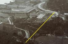
The photo (from 1910) below shows the approximate course of the cutting (line added by me). As mentioned in the 1921 PWR, the houses in the bend of the road (bottom centre) will be demolished for the widening of the road.

The location of the cutting and new road can be seen on the 1952 map, the old road is still there as dashed line.

The works progressed satisfactorily as the 1922 PWR reports:
Substantial progress was made with it. Up to the end of the year 30,000 C.Y. of rock was removed from the line of the road and deposited to form the rubble mound to enclose the reclamation opposite Q.B.I.L. No. 4. The nullah, the retaining wall adjoining the Recreation Ground, and the small culvert for carrying the water main under the new roadway were completed, whilst 300 feet of the 12 foot nullah adjoining the Refinery was widened to 24 feet.
Not so successful in 1923 (PWR 120a):
The progress made during the year was not up to anticipation, owing chiefly to delay in obtaining the surrender of the necessary areas required; at the close of the year, there still remained to be handed over the areas occupied by 50 houses. The first temporary diversion of the tramway was effected in January, and the second in November.
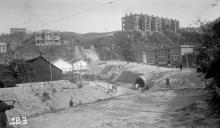
The houses mentioned in the report are the ones on this photo:

The Report continues:
The following items were completed during the year:—
70 feet of the 16-foot culvert under the new road, and a length of the wall adjoining the Refinery, in addition to minor extensions to culverts and drains ; 11,000 C.Y. of material was excavated below Taikoo Terrace and deposited on the road line and 64,000 C.Y. of earth removed from the Quarry area and deposited on the Reclamation.
Still worse in 1924 (PWR):
The progress made was very unsatisfactory, due to the dilatory manner in which the Contractor carried out his work. The Contract was closed in July.
The excavation within the area of the Quarry was completed and the material deposited in the Reclamation; but this was not the case below Taikoo Terrace. The main culverts were extended as far as possible to carry the road on its new alignment.
This shows the culvert under the new road.

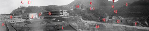
On this photo the progress of work (cutting) in front of Taikoo Terrace can be seen in this photo from 1924:
Nothing reported in 1925 and 1926, but in 1927 (PWR):
The carriageway of the new Shau Ki Wan Road between the Taikoo Sugar Refinery and the Taikoo Dockyard was regraded so as to meet the level of the new Tramway track.
As the Public Works Reports do not clearly state a date when the new road was finally finished, the date is estimated to be 1927. The result can be seen on this photo.

The new road cuts through the hill between Taikoo Terrace and the lower Stanley Terrace, leaving Taikoo Terrace and the neighbouring buildings almost on an “island”.
Photos that show this Place