From Quarry Bay, there's a pleasant walk up Mount Parker Road to Quarry Gap. As you reach the crest of the gap, just in front and to your left is a large flat area. There are some picnic tables there now, but it always looked to me as though it had been cleared & levelled for some greater purpose in the past.
When I read Tony Banham's 'Not The Slightest Chance', I noticed that today's Quarry Gap was referred to as 'Sanitorium Gap' in the 1940's. So it seems likely there was a Sanitorium building here at some point. [Wikipedia defines the term as follows: A sanatorium (also sanitorium, sanitarium) is a medical facility for long-term illness, typically tuberculosis.]
Then I forgot about it until Geoff's comment today about the Mount Parker hillside:
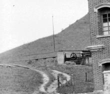
Or it could be part of the old network of nullahs that were built by Taikoo dockyard to the feed the dams that had to built as part of the agreement between Swires and the Govt. Essentially as part of the sale of the land for Taikoo they had to build dams to supply water not only to the docks but to both Shau Kei Wan and Quarry Bay. There was also a cable car system on Mount Parker that took the ex pat families to the bungalows in the hills, that were used mainly in the summer to avoid the heat. Pictures of the nullahs and cable car system are in the link to Historic Pictures of China (if you can be bothered to trawl through about 200 photos!)
The Historic Pictures of China he mentions are described here. One of the photos gives a clear view of the cable car (click the thumbnail for a larger view), and down in the valley you can see a white patch which is the reflection of the reservoir. I think this photo was taken from the gap.
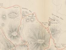
A more careful look through the Mapping Hong Kong shows the 'Tai-Koo Sanitarium' on plate 7-1, a tourist guide map from 1896. It also mentions the building in one of the guide's suggested sight-seeing routes:
PROGRAMME No. 7
Proceed by ricksha to Bay View [a building that stood near where Tin Hau MTR is today], as the road is too long and uninteresting up to this point; thence walk to Quarry Bay, where, after having passed the entrance to the Sugar Refinery, about one hundred yards further on, just before crossing a bridge, you will see on your right hand, the pathway up the hill [the pathway is today's Mount Parker Road]. Something under one hour should bring you to the top, which is only a gap about feet 1,000 [sic.] above sea level. Here are the Sanatorium buildings of the Taikooo Sugar Refinery, Messrs. Butterfield & Swire. [The walk continues down to Ty Tam reservoir, up to Wongnai Chung Road, then down to Happy Valley, where 'we can obtain a ricksha to convey us to town.']
That same map shows a dotted line that runs from near the 'Tai-koo Sugar works' up to the Sanitarium. I wonder if this was already the cable car in place?
Plate 2-12 in the same book is a wartime map, dated 1939-40, and overprinted with Japanese. It shows the 'TaiKoo Sanitarium' building, connected to the 'Sugar Refinery' by an 'Aerial Ropeway', so it was in use then.
Plate 2-13 is a 1949 map. It still shows a dotted line along the course of the ropeway, and the outline of the sanatorium building is there too. Neither are labelled though, and the Gap is now labelled 'Quarry Gap'. So, perhaps the building and the ropeway were damaged during the war, and were never repaired afterwards?
More information about the ropeway / cable car here.
If you can add any more information about the sanatorium please leave a comment below.
Photos that show this Place
Comments
Taikoo Sanitarium
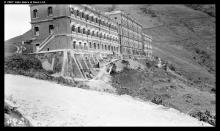
I think this is a photo of the sanitarium building - click the thumbnail for a larger view.
sanitarium foundation
Now some structures are still visible down the slope facing Tai Tam Reservoir. They are very similar to those buttresses supporting the building as shown in the photo. Are they part of the remains of the building?
re: sanitarium foundation
I've assumed those flat areas on the Tai Tam side of the gap are the platforms that the sanitarium was built on, but wasn't 100% sure. You make a good point that we should be able to compare the old photo with a modern-day photo of the retaining walls, and see if we can match up the stonework.
Taikoo sanatorium ?
Here is a photo with the caption "Taikoo Sugar Refinery and sanatorium, Hong Kong"
It doesn't look like it is at Tai Tam Gap.
http://vcea.ish-lyon.cnrs.fr/VDB/Files/?Table=Image&ID=Image.ID.19726.No.0&Op=O
Photo
Thanks to Geoff Douglas for pointing out these two photos. The lower photos shows the Sanitarium / Summer Flats up at the gap: http://www.facebook.com/photo.php?fbid=3064690174788&set=o.21271626725&…
Regards, David
Sanatorium at Quarry Gap
I visited the terrace south of Quarry Gap recently to try to confirm if the two photos linked to David’s posts of 25-8-2009 and 23-3-2012 were taken there. They were.
The terrace is only a few meters south of The Gap. It sits on a roughly west-east axis, is about 90m long and 8-10m wide for most of its length. At the eastern end, the rock at the rear has been excavated to increase width.
Along the southern and western edges the terrace is supported by a buttressed wall of up to 4 – 5m in height. As Anonymous noted on 19-5-2010, the foundations supporting the terrace today are very similar to those seen supporting the building in the old photos.
The photo at;
http://hpc.vcea.net/Asset/Preview/dbImage_ID-19727_No-1.jpeg
clearly shows the near end of the foundations are faced with stone, and the buttresses rise at an angle initially, becoming vertical near the top. Towards the middle of the terrace, the level of the ground beneath it rises, requiring shorter buttresses. All these features are still present today, but difficult to photograph due to the thick undergrowth. The road in the foreground of the old photo is Mount Parker Road, running down to Tai Tam. Today it’s not possible to see the terrace from this point on the road due to the heavy tree cover.
The old photo shows a small building behind the sanatorium, sitting right on the top of Quarry Gap. I wonder if it’s the wheel-house for the cable car, or aerial ropeway, running down to Quarry Bay discussed elsewhere on Gwulo?
The photo at;
http://www.facebook.com/photo.php?fbid=3064690174788&set=o.21271626725&type=1&ref=nf
is taken from the opposite end of the sanatorium and shows, at its centre where it’s four storey’s high, the buttresses appear to be constructed of horizontal layers of different materials, and extend upwards as far as the first floor of the building.
Today, it can be clearly seen that the central buttresses were made of horizontal layers of concrete and stone, but have been cut off at the ground level of the terrace, presumably at the time the sanatorium was demolished.
The second of the old photos shows the building from the east, and was taken from roughly the same height as its roof. A short distance up the road from Quarry Gap to Mount Parker, a footpath, sign-posted Boa Vista, leads off to the right. Follow this path for a few minutes, and you’ll be roughly where the old photo was taken from. Looking back towards The Gap reveals the view in the second of the old photos, with Mount Butler in the background.
Both the old photos show only one sizeable building at The Gap. It’s long, narrow and sits roughly on a west-east axis. However, two of the maps in “Mapping Hong Kong” make me wonder if there were two buildings there initially?
Firstly, Plate 7.1 in “Mapping HK” is a map dated 1896 that marks two clearly defined, rectangular buildings adjacent to each other and standing in-line on a west-east axis on the terrace. The accompanying text says, “...here are the sanatorium buildings of the Taikoo Sugar Refinery”. Note the use of the plural, “buildings”.
Secondly, in a map tentatively dated in the 1920’s/30’s (Plate 2-11, “Mapping HK”), the two distinctly separate buildings are again marked. Later maps show either one building on the west-east axis (Plates 2-12 & 13) or no building (1938 1: 20,000 O/S Map).
The website hosting the first of the above old photos dates it to 1911/12. It’s possible, but unlikely, that two buildings existed in 1896 (date of the first map), one in 1911 (date of the old photo), but two again in the 1920’s-30’s (date of the second map). More likely, one of these dates, or the marking of two separate buildings, is incorrect.
According to “Mapping HK”, the 1920’s/30’s map is difficult to date due to inconsistencies within it, so it wouldn’t be totally surprising if it had merely copied the 1896 map, even though the two buildings may already have become one. Another explanation is that both the 1896 and 1920/30’s maps are incorrect and only one large building ever existed at the terrace. But, if only one building was present in 1896, wouldn’t it have been simpler to mark it on the map as such, rather than as two?
I wonder if the sanatorium was initially built as two adjacent buildings, which by 1911/12 were either joined in the middle, or demolished and replaced by the single building seen in the old photos?
re: Sanatorium at Quarry Gap
Hi GW,
Thanks for the extra photos & information.
The two oldest maps don't show the buildings to scale, so they might just have been a rough indication of "there are buildings here", rather than an accurate count of two buildings. On the other hand why draw two if there was only one? One more mystery to be solved.
Regards, David
Sanatorium at Quarry Gap
Having tried and failed on numerous occasions to find older photos of the sanatorium at Quarry Gap, I'd more or less given up hope of finding out if it was originally built as one or two buildings...until browsing the HK History Museum's online photo gallery today.
The photo at the link below gives the answer.
http://mhmcms.lcsd.gov.hk/aspnet/aspx/entree.aspx
(this takes you to a search box.
In "Description" type "Taikoo Sanatarium",
in "Period" type from "1890" to "1900",
in "Collection Type" select "Historical Photos",
Click the "search" button.)
The photo shows two separate buildings. Comparison with the two photos linked in my earlier post above confirms that at some point a central block was built between the two originals to form one long building. Additional buttresses, larger than the originals, were added in the middle of the terrrace to support the new, taller, structure, explaining why the design of the central and peripheral buttresses are different as can still be seen today.
The HK History Museum photo is dated 1895 and is earlier than the photos and maps mentioned in the earlier posts above. Best guess at the chronology of developement of the sanatorium is;
- Prior to 1895. Two buildings built on terrace at Gap (source: the HK History Museum photo dated 1895).
- 1896. Two buildings still in place (source: Plate 7.1, Mapping HK dated 1896).
- Prior to 1911. Middle block constructed (source: photo dated 1911 on the vcea website linked in the earlier posts above).
If correct, this means that the map at Plate 2-11 of Mapping HK, tentatively dated "1925 to 193?", showing two seperate buildings is either inaccurate or was produced much earlier. As Page 42 of Mapping HK comments upon the inconsistencies of this map, I'll go for "inaccurate".
My failure to find the 1895 photo earlier just goes to show I'd forgotten an obvious source of great photos, searching instead in more obscure places. The HK History Museum has a very interesting collection of old photos, although each one bears a very heavy and large watermark that can sometimes obscure or confuse the detail you're looking at. Thanks David for your link to it on page 2 of your "Photos of Old HK" page.
re: Sanatorium at Quarry Gap
I'm glad to see you've pinned down the development of that centre block. I'm still hoping we'll find out when the first blocks were built, and when the site went out of use and was demolished.
Regards, David
PS Here's a direct link to that Museum of History photo: http://mhmcms.lcsd.gov.hk/aspnet/aspx/enlargeImage.aspx?link=en_US&wacimg=WAC.gif&imgid=../upload/OI/P1967/8/_381618d84a974f6485fb25ff34e812a7.JPG
re: mount parker
Incidentally, I assume Mount Parker was named after Admiral Sir William Parker, who fought in various China battles around 1841, under commander Sir Hugh Gough
http://en.wikipedia.org/wiki/Sir_William_Parker,_1st_Baronet,_of_Shenstone
http://en.wikipedia.org/wiki/Hugh_Gough,_1st_Viscount_Gough
Tao Koo Saniitarium
An interesting article on the website of "The Industrial History of Hong Kong Group" at;
http://industrialhistoryhk.org/aerial-ropeway-1891-1932-sanitarium-1893…
contains more information on the development of the sanitarium and ropeway and quotes the following significant dates;
1891 - aerial ropeway built.
1893 - sanitarium buildings (two adjacent blocks) built.
1911 - middle section of sanitarium added, making one continuous block.
1932 - sanitarium and ropeway demolished. Actually the website says, "By 1932, both the Sanitarium buildings and the aerial ropeway were demoliished,...", leaving the possibility that they were demolished earlier.
re: Tai Koo Sanitarium
Hi GW,
The 1932 date comes from C. M. Guildford's summary of Civil engineering in Hong Kong (see https://gwulo.com/comment/9388#comment-9388):
Since this article was first published, a reader has kindly advised
that the purpose of the "overhead tram" referred to in the section on
Water Supply was not as suggested but to provide access to two blocks
of flats used in the summer by the Tai Koo sugar refinery staff. It was
probably erected in 1891 and survived until 1932 when both the flats
and cableway were dismantled.
He doesn't name the reader or quote their source, but they sound confident that is the date the blocks were demolished. I've added in 1893 as the construction date and 1932 for demolition for now - corrections welcome.
Regards, David
1932 Tai Koo Sanatorium
HK Telegraph 5 December 1931
HK Telegraph 21 January 1932
1932 it is!
Thanks Moddsey,
Regards, David
Sale of RBL 63
RBL 63, at Mount Parker Gap was scheduled for public auction on 25th September 1888 (Government Notification 409/1888).
"A lot of Crown land, RBL 63, at Mount Parker Gap was put up for auction yesterday afternoon, and was purchased by Messrs. Butterfield & Swire, on behalf of Taikoo Sugar Refinery, for $1,870...We hear it is the intention of the purchasers to build a sanitorium for their employees at the refinery". (Hong Kong Daily Press, 26 Sept 1888).