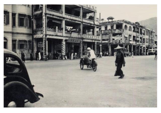
[UPDATE Dec 2018: The location has been identified in the comments below.]
Does anyone recognise this?
It's a very wide road, maybe Nathan Road?
The building on the far left is a distinctive design, different from the other shophouses we can see.
And the building we can see across the junction has an unusual shallow dome on the roof, which might trigger someone's memory?
Source: This image came from Flickr, see https://flickr.com/photo.gne?id=4312380056
Date picture taken
1930s
Gallery
Shows place(s)

Comments
Re: 1930 unknown location
Hi there,
Lai Chi Kok Road was (and still is) just as wide, but I really have no idea where was it. I'm way to young to know about these. A small fraction of the Chinese words are still readable but not all of them. Most are either the name of the business or advertisements, but it's not much.
The photo also showed a street sign, but it was too small to tell anything.
Best Regards,
T
Prince Edward Road East End
Greetings. That flying saucer with legs on the roof top is the same one in this photo - https://gwulo.com/atom/31323 , which shows the same shophouses (and same name of corner shop) and ridgeline. Regards, Peter
re: Prince Edward Road East End
Thanks Peter, good to have this one identified. Looking at the map below, I guess that the flying saucer building was on the corner of Tak Ku Ling Road and Prince Edward Rd. Though I think the map below was a planned layout, and the actual layout was slightly different, as this block of buildings in the photo looks wider than the next two blocks along Prince Edward Rd. I'll update this if a later map becomes available.
Prince Edward Road east end
Greetings. One Time I toured the street and came upon that building on the far left with a distinctive design. Like many other photos, this is another walk down memory lane. I don't know which came first, it or the ajacent shophouses, likely the latter.
That dome structure, I believe, was not on a roof top. It would not have functioned well as a shelter to keep wind and rain out. It looks massive, hence costly to build and would have to be anchored well to withstand typhoon. Could it be a part of the factory? https://gwulo.com/atom/30363 - the tall object on the left of this photo, a bit up the bend and to the right, seems to show the same structure. Ditto for that long vertical pipe (chimney?) Regards, Peter
Re: Pavilion on roof top?
Hi There,
I believe that Pavilion may be sort of Feng Shui stuff. I remember there is another similiar one in Traditional Chinese Style that still exist today in Pennington Street in Causeway Bay, clearly visible from Google Maps.
T
Looking at the old maps, I…
Looking at the old maps, I believe the dome/flying saucer on the roof is at the entrance of Po Kong Road. This road was later redesignated as Kai Tak Rd in 1954 when the Airport was redeveloped.