Source: This image came from Flickr, see https://flickr.com/photo.gne?id=11412157323
Date picture taken
1954
Gallery
Shows place(s)
Source: This image came from Flickr, see https://flickr.com/photo.gne?id=11412157323
Comments
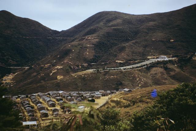
Sai Wan War Cemetery
I think the above photo was taken from Tai Tam Road near the junction with the road down to the "Sai Wan Fresh Water Service Reservoir". It's not possible to take a photo from there today due to trees, but from well above Tai Tam Road you get this similar view.
Sai Wan War Cemetery is just visible through the murk on the lower slopes opposite. The large housing block standing end-on to the camera just to the left of centre is Wo Hing House (I think), Hing Wah II Estate. To its right, standing on higher ground and partly visible through the bushes, is the Sai Wan Fresh Water Service Reservoir, a "covered" reservoir. Comparing this photo with the old photo, I think the huts in the old photo were standing on the site that later became the Service Reservoir. Having looked around the area, I couldn't find any other raised flat area it could have been.
Page 239 of Mapping HK contains a small 1958 map entitled "Chai Wan Resettlement Area, Hing Wah Village", but I can't work out the exact area it covers within what we know as Chai Wan today. However, the map shows the "village" on a raised area with the Star of the Sea Chapel below it. Today a church of the same name stands close to, and below, Hing Wah Estate. I believe todays church is a new building, but I'm not sure if it was built on the same site as the old one.
Given the close proximity of todays Hing Wah Estate to the probable site of the huts at todays Service Reservoir, and the mention of Hing Wah Villlage in the 1958 map, perhaps the huts in the 1954 photo were known as Hing Wah Village.
I can't figure out how to
I can't figure out how to post a photo here in my reply, but I posted a photo of the other end of this village,taken at the same time in 1954-I titled it "Hing Wah Village 1954"
How to post a photo in my reply
Hi Doug, Here's how to post a photo in your reply:
http://gwulo.com/node/1929
Regards, David
I've since had a person who
I've since had a person who actually lived in one of these huts at the time respond to my photo on Flickr-he says that this area is indeed Hing Wah Village.
re: Sai Wan War graves
Hi you might find out some details from this history of the area:
http://www.amo.gov.hk/form/HIA_Report_CWFE.pdf