Source: This image came from Flickr, see https://flickr.com/photo.gne?id=6567929725
Date picture taken
1970s
Gallery
Shows place(s)
Source: This image came from Flickr, see https://flickr.com/photo.gne?id=6567929725
Comments
Re: South China Morning Post
Hi There,
I remember the South China Morning Post was in the area back then, up to the point when Swire redevelop the lots around Tong Chong Street into Tai Koo Place.
Thanks & Best Regards,
T
Additional old places behind Taikoo
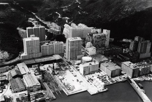
In the upper left quadrant shown quite distinctly -
.following a line up the hill towards Mt Parker, the 3 buildings of Stanley Terrace, then The Bungalow, and above that another reservoir [colloquially referred to as "Bungalow Dam"].
.between Stanley Terrace and Woodside, the Refinery reservoir above Quarry Bay village.
- Geoff W.
Good View of Stanley Terrace
Good aerial view of Stanley Terrace on the ridge. Quarry Bay Junior School is also visible. SCMP relocated to Tong Chong Street in 1971 into former factory buildings (Lincoln House) of the Sugar Refinery.
re: Additional old places behind Taikoo
Hi Geoff,
Thanks for the extra info. Were there any different names used to differentiate between the three blocks of Stanley Terrace?
"The Bungalow" is a new one for me. What was it used for? If you look at the map at:
http://gwulo.com/map-of-places#16/22.2825/114.2154/Map_by_ESRI-1952_All…
Would the Bungalow be the building shown by the "R" of "Rifle Range" ? I'll make a new page for it.
Regards, David
Stanley Terrace and The Bungalow, Quarry Bay
David -
The 3 buildings comprising Stanley Tce were known informally [from north to south] as Bottom Tce, Middle Tce, and Upper or Top Tce - highly imaginative ! - and probably a little confusing as there were 3 levels for every designated Number - you guessed it - Bottom , Middle, and Top. Thus in the 1940s-50s I lived initially at No. 11 Top in Middle Tce, and then at 15 Middle in Top Tce.. Nos. 1-8 were in Bottom Tce, 9-12 in Middle Tce, 13-16 in Top Tce, i.e. 48 apartments in all, with the corresponding servants quarters in detached 3 storey buildings immediately behind.
As these buildings were for expatriate Dockyard staff I imagine they were constructed from about 1907 onwards, and I think Bottom Tce was the oldest, and Middle was older than Top Tce, judging by style differences. I understand in the early days there was also a "Taikoo Terrace", on the other side of the [later] Kings Rd cutting. The ridge Stanley Tce stood on was being levelled when I visited in 1976, so I assume it was demolished not long before that.
The Bungalow is indeed the building you identified on the map, with the "Bungalow Dam" above it. This was Dockyard staff accommodation too, with 2 - 3 single storey apartments all on one level. I don't know when or why it was built, but it was probably initially for senior executives similar to the 2 Kornhill buildings.
It was a long way up from Kings Rd, with no vehicular access [ditto Stanley Tce], but there were 2 or 3 sedan chairs waiting at the road, and the coolies were provided with accommodation on the spot by the Dockyard.
Quarry Bay Junior School, as it then was, is middle on the right of the photo.
Regards - Geoff
Quarry Bay
Thanks Geoff, good info. I've added it and made pages for the new locations.
Regards, David
Gas Holder
On the area of the former Taikoo Sugar Refinery, a Towngas gas holder is visible.