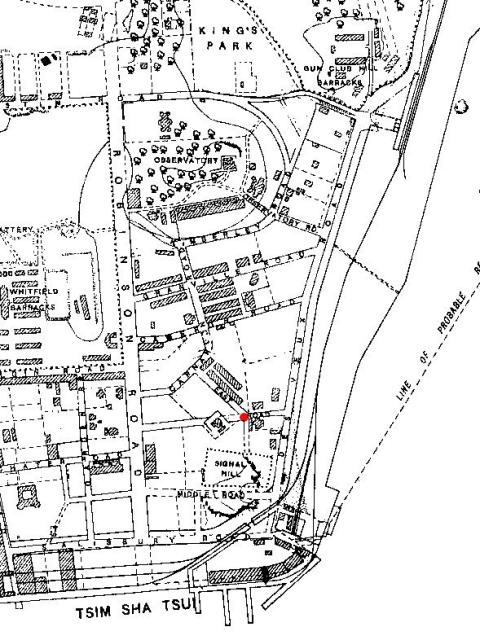
Map of the area described here. Map is part of the 1902-3 8-inch series, reproduced in the "Mapping Hong Kong" book.
When the map was made, the road from the junction marked with the red dot ran northwest to Carnarvon Road, and east to today's Chatham Road. The road was named East Road. The road heading west from the junction to today's Nathan Road looks like it was planned but not yet built, as there is a building right in the middle of the road!
You'll also see Chatham Road was called Des Voeux Road at that time, and Nathan Road was called Robinson Road.
By the 1924 map, today's names are in use:
- The East-West road is complete, the obstructing house has disappeared, and the road is now named Mody Road.
- The short orphaned northwest section of the old East Road changed to today's name, Hanoi Road.
- Des Voeux and Robinson Roads are renamed to Chatham and Nathan Roads, respectively.
Comments
the chatham road mansions
So from looking at the photo taken from signal hill, it would appear that Knutsford tce. ran along the south base of the observatory hill overlooking Kimberley road. I am assuming that Knutsfod Terrace was a military establishment; Married Quarters? It is certainly a substantial building!The building directly above it is The Royal Observatory admin. building, which as far as I know is still there. I am very keen to learn more about early Kowloon as I spent most of my child hood there as a government brat.I have several interesting photos of Jubilee Buildings in Sham Shui Po and of Stonecutter's Island circa 1946/7. Checking-out the Google satellite image of Stonecutters the other day, I was amazed to see that the small block of flats that my parents lived in ,are still there! We lived in Cox's Path for over eight years and that's another place i'd like to know more about.Whilst we are in the vicinity of Mody/ Chatham roads, around 1955 we stayed in the Arlington Hotel,which was virtually opposite the Lyton House Hotel. I can remember my Father taking us kids across Chatham road to the NAAFI Club next to the railway line where we used to play whilst he quaffed beer with his ex navy mates.
Knutsford Terrace
Knutsford Terrace ran along the southern slope of Observatory Hill and comprised of garden lots adjoining each other. It was not a military establishment. The 1905 list of common jurors who listed their place of residence as Knutsford Terrace also indicated these residents worked for foreign companies and the notable 'hongs'.
Research on the historical buildings in Knutsford Terrace can be found on this link.
Tsim Sha Tsui area
Thanks for that info on Knutsford Terrace. If I wanted to know more about Cox's Path, ie; history and archetectural plans, how would I go about it?
By the way there's an excellent photo of Lyton House Hotel at http://www.weather.gov.hk/wservice. The subject of the photo is the tower on Black Head Signal station.
Cox's Path
Rich,
I couldn't see the photo you mentioned at the link above - any chance you could double-check that the url is correct?
We'd also love to see those old photos of stonecutters & jubliee buildings you mentioned, so please send us the link if you post them online (or we'll be happy to post them here).
I don't know of anything specific to Cox's Path, but here's a list of general resources for HK history you could try searching. It'd also be worth clarifying exactly where you lived - on a 1924 map the road between Jordan Road and Austin Road is named Cox's Path. By the 1947 map that has changed its name to Cox's Road. Current maps use the Cox's Road name, but also show a Cox's Path which is a short alley running southwest from Cox's Road, parallel to Jordan Road.
Regards, MrB
Sham Sui Po and Stonecutters
Please share your photos. I lived at Sham Sui Po Police Station in 1946/47 and also went .22 shooting (using converted .303s called "number eights") and swimming on Stonecutters in the early 1950s. I fired on a 25 yard range, while my sister, a WREN, fired full bore .303 on the range that ran along the beach. I have memories which pictures may clarify, for which I would be most grateful.
Sham Sui Po and Stonecutters
Stephen, many thanks for the batch of photos you've uploaded - very interesting to see. Thanks for taking the time to set up the places too.
I've put up a few notes about Sham Shui Po Barracks / Camp, which I think would have been right next to the SSP Police Station. I've also linked a few photos to the Stonecutters Island place - you may have seen them already, but worth a quick check.
You might also recognise some of the places shown in Geoffrey's photos.
Regards, MrB