Received via email:
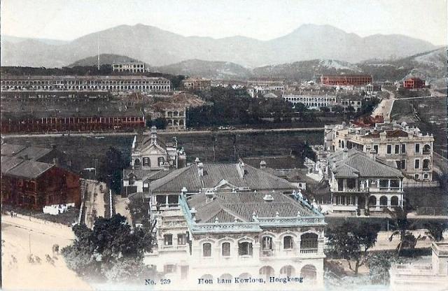
The postcard most probably was taken from Signal Hill looking down onto Mody Rd and looking north across the side streets that connect Chatham Rd with Nathan Rd.
Knutsford Terrace is the long row of houses on the top left. Chatham Rd is on the extreme right with the road leading up to Gun Club Hill Barracks visible just off to the right turning road leading to Hung Hom.
The long road in the middle looks like Granville Rd. The mansion on the flickr set would most probably have been located south of Granville (probably Cameron) and may well be one of the houses seen on the right.
Date picture taken
1910s
Gallery
Shows place(s)
Comments
Mansion on Chatham Rd.
The one in my photo must be the yellowish one on the far right. I used a similar photo from the Hong Kong Prublic Records Office (online) to identify it. If you look closely at this photo, you can see that the rear of the mansion has two exits, so it was a duplex (semi-detached). The Semichon/Grandel family lived in the southern half between 1908 and 1913, but I think I'll have to visit the PRO personally to get details.
Mansion on Chatham Rd
Another email:
Mansion on Chatam Rd
The building on the foreground could be the one I am thinking which was located on the south side of Moody, where Hart Avenue and Hanoi Road meet (Moody Hotel). I am trying to track down my primary school class-mate who lived in that hotel in the 1950s. He might be able to recall his times and this neighbourhood while there.
Cheers.
OldTimer
Map of Mansion on Chatham Rd
Here's a section of the 1902-3 map of the area.
The red dot marks the junction seen in the lower left corner of the postcard above. Note that neither the yellow-tinted house at the far right of the postcard, nor the red-roofed building behind it appear on this map, so the Grandel house should have been built after 1903.
Mansion on Chatham Rd
In one of the photos of the flickr set, mention is made of the possibility that the mansion was called 'Holyrood' after the famous Scottish castle. A search through the government archives indicates that the Holyrood mansion in Kowloon was first mentioned in February 1905. Three gentlemen on the jury list who worked for notable 'hongs' at the time listed their place of residence as 'Holyrood' Kowloon. This would tie in with the building being built probably after 1903 and prior to 1905.
A search for the Grandel and Semichon family names, however, proved fruitless.
Mansion on Chatham Rd
So it is likely that Jules Semichon worked for one of the hongs at the time. Perhaps the French Consulate in HK could still be archiving records from those years about the French citizens living in HK then. Furthermore, could this area had been a so called "French" area of HK during the late Victorian era? MrB mentioned one of the roads in the neighbourhood was renamed to Hanoi Rd. Hanoi for me conjures up images of French Indochina...Vietnam, Cambodia, Laos and so on.
Mansion on Chatham Rod
Regarding the hotel in the foreground of this photo, my friend said the following:
"Yes, it was Lyton House Hotel where I lived from 1956 to the late 1960s. I think it was #4 Mody Road. This was my father's hotel which catered to British Army officers exclusively."
Physically, it was located on Mody Road. I have visited him many times at this hotel. What a great photo to recall my childhood memory standing on that top floor balcony!!!
Lyton Building
The old hotel building above is long gone, but the building that stands in its place today is called the Lyton Building. It's at 32-48 Mody Road.
As a further link to the past, there is a Lyton House Inn guesthouse in the current building.
MrB
Lyton house
L
yton house
Date of Knutsford Terrace Postcard
Just checking old photos showing the Observatory and come across this one. On closer look, the first-generation typhoon signal mast (1917-1932) is clearly visible to the left of the Observatory Building. Furthermore, the extension (constructed in 1912) on the left hand side of the Observatory Building can also be seen. Thus this postcard has to be dated after 1917.
Mast & extension
Thanks for the details, they will be handy references for dating future photos.
Regards, David