Uploaded from the website of the University of Bristol: https://hpcbristol.net/visual/NA16-098
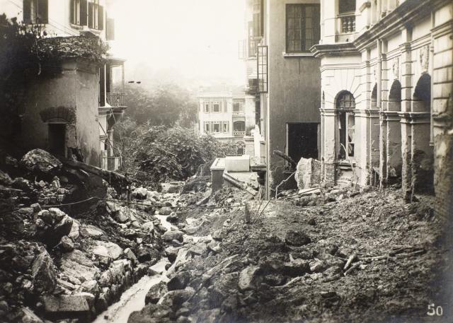
The caption reads: PATH FROM KENNEDY ROAD TO TRAMWAY PATH. This should be today's St. Joseph's Path. Can't identify the buildings, please help.
Update: buildings identified, see comments below.
Date picture taken
19 Jul 1926
Gallery
Shows place(s)
Shows event(s)
Comments
If we assume that the photo…
If we assume that the photo does not show St. Josephs Path but a path a bit to the west, possibly above the Albany Nullah as shown on the 1924 map, then the building on the right should be Club Germania. The shape of the windows and the tower at the edge would fit. If so, the building on the left would be 4 Kennedy Road. The path can be seen in the photo below between the two buildings just mentioned.
Re: Main Photo
St. Joseph's Path was formerly called Boundary Path. This path was to the east of Club Germania and appears in the lower photo.
Yes, the path (not named) in the main photo had a nullah beside it and was located between Club Germania (western side) and 3-5 (formerly 2-4) Kennedy Road. Source: 1938 Street Index.
The path and nullah curves northwest on its descent from Kennedy Road and gives a head-on view of the rear of the Helena May. The building on the right should be the Club Germania and further up at centre right is the West Block of St. Joseph's College.
1909 Club Germania
Matching of the pillars of Club Germania on its eastern side shown in the postcard below with those in the main photo. Should be a mirror-image,
Additional Photos of the Path from Kennedy Road to Tramway Path