It's forever a happy thing to know of the old Cheung Chau!
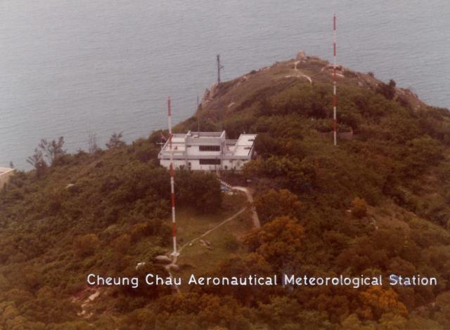
CC NDB is the term used for the Air Traffic Control as the System equipment for Cheung Chau Non-directional Beacon on the site of the #30 House, the Last house of the Peak Road west. Also known as the Radar Station.
For those who have been following the Laura's Mystery Rock on Cheung Chau postings, may find my recent story of the nearby Radar House an interesting discovery of its past glory in Hong Kong's Air Traffic History.
Do yourself a favour to visit my story:
' Cheung Chau NDB Approach for airliner traffic prior to IGS era '
Reference the above posting, the captioned story and subsequent replies were first mentioned here under "Mystery rock on Cheung Chau". For ease of reference, the comments have been copied over onto this thread.
a) Cheung Chau NDB approach for airline traffic prior to IGS era
It is a happy time to go down the CC memory lane again and glad to recall some long-lost scenario related to the aerial photo in one of the previous postings. A photo of the south island of Cheung Chau as seen by air pilots over the Vicinity of the Laura's Mystery Rocks and the Peak Road west area.
These pilots would come over from the Italian Beach (also known as Pak Cho Wan), follow the Peak Road west, encounter the two Barbers Poles of the Radar House by their west, and fly over the huge boulder west of #27 house. Now the jetliner already on a gentle descending flight path homing onto the Tai Choi Yuen, a valley of farming and residential mix, at about 300 feet level and unload the landing gear.
The continual jet engine noise thundering upon the community below is truly deafening. A diagonal line cutting through the upper-left quadrant of this photo below would be part of the flight route mentioned here.
Now the jetliner would go on a level flight at about 200 feet, over the valley of rows of farmer's fields, my home at the top of other side of the valley, the Government High School, the Power Station. There were lots of old-grown trees along the way and the last house they flew over was the island's Police Station on the beachhead of Tung Wan Beach. Beyond this point the jetliners would increase the throttle and retract the landing gear, taking off to its flight again at a higher level. The entire CC passing is somewhat over a mile long. Or about fifteen to twenty seconds depending on actual flight speed.
There is a rear view photo as the plane passing over The bueatiful Tung Wan, from the same '18 districts/islands photo gallery ' . Select the 2nd ' Aerial view of Cheung Chau'. The entire flight path is on the left, you may sort out the details here yourself.
In the 1950s and 60s the Peak Road west also offered a good place to enjoy the airliners lineup as they 'tried' to land on Cheung Chau. The airliners or later the jetliners would fly in from about 5 km south-west from the Italian Beach on descend by homing onto the CC NDB radio signal station (Locals called it the Radar Station). This flight path would give the pilots a direction heading to the next NDB station at the Stonecutter Island.
While over the airspace of the south island of Cheung Chau, usually they were flying way below the 1050 feet ceiling. However most commercial jetliners would take on a let-down approach to as low as about 250 feet during passing over the south island. That was quite an awesome viewing to many islanders and youngsters liked myself. Of course the pilots couldn't located the runway, there was none actually, so they headed up again as they reached over the water of the Tung Wan beach and flew toward the Stonecutter Island in the western Victoria Harbour where they would turn right to over the city of Kowloon, and then proudly made a cool and very tight turn right in front of the notorious Checkerboard seconds before the final Kai Tak Airport landing.
Most people outside the Cheung Chau island did not know much about the CC NDB approach. Government never talk about it. More than once an air-traffic controller came visiting my family and he didn't tell me anything. Maybe he wanted no trouble on his job.
Nevertheless, we now learned from retired pilots that some of them did enjoy the CC NDB Approach, quite exciting as for a real man! And I know it very well.
The joyful runs ended in the early 1970s with newer flight path system called the CH NDB and later the CH VOR/DME....IGS.... pretty confusing. Which just meant the jetliners would no longer fly over the south island and on let-down approach, but would fly over the north island on a higher level like 1000 feet or so. A less risky approach to the island.
As a kid, I enjoyed the awesome passover and its deafening noise! They flew over my head many times a day for many years! Children of Cheung Chau had named a game they loved to play in small group as ' hopping (on) the airplane game' and it could well be inspired by the joy of watching those low flying passing airplanes.
There is a set of old Cheung Chau photos taken by the Global-Mariner, from the hill-top of Peak Road west--the Radar Station area. They were the few nearest equivalent views of the air travellers could have seen through the left-side windows of the airplanes. And the flight route was just along the outside of the right margin in the first picture.
Here is a dreamed dialogue between the Control Tower at Kai Tak and a B707 pilot in 1965:
Pilot: Hello Kai Tak , we are CA501, 10 km west of CC NDB and closing in, for Kai Tak on RWY 13, over.
Tower: CA501, CA501, we read you. Welcome to the Colony. The weather is near perfect with just a mild shower cloud 600 feet above Cheung Chau NDB vicinity. Please keep 180 knots as you're OK to proceed with due care. Over.
Pilot:( the B707 just enters in the dark cloud) Jolly Good! Thanks Tower, over.
Tower: CA501, CA501, where are you? we don't see you on the screen. Please report position! over.
Pilot: (trying to identify the island features amid the wetty cloudy air)
Pilot: CA501 calling Kai Tak, we are fine! over.
Pilot: CA501 just coming out of the CC shower Cloud bueatifully at 300 feet and still on gentle descend. Speed 180 knots, holding well and just passed the CC NDB in good wet. Over.
Pilot: Hey, look, there they are... the Mystery Rocks group on the cliff nearby, beyond the two Barbers Poles. over.
Tower: This is Kai Tak calling CA501. Happy to hear you're OK! Just to let you know that my boy at the Cheung Chau Police Station has his ground-to-air missile ready to shoot any planes flying below the 199 feet threshold for protecting the island. Am I making it very clear to you? over.
Pilot: CA501 understands Kai Tak's joky reminder very well and is just now passing over CC at 200 feet with a free shower wash, over...... this bueatiful island. over.
Tower: CA501, your Cheung Chau Passover's well done. Your next call is about 10 km ahead. Good Luck! But be serious to watch out for the hillside Checkerboard ahead prior RWY 13, it is a huge sucker-Magnet, over.
Pilot: CA501 calling Tower. Thanks for Checkerboard advance warning, since the ChessMaster already missed the flight. None of us on-board would dare to play the game. No match today. over.
Tower: CA501, anything else we can do for you, over.
Pilot: CA501 calling Kai TaK, just give us a million dollars. over.
Tower: OK CA501, That's easy indeed. The cash car is sitting on the runway to meet you! Over.
Pilot: Oh my Heaven! over.
End of the Dreamed talk!!
Hope that someone will share on the same topic. Thanks
Tung
PS a picture covering the flight path will be posted later. The mystery rock group can also be seen too.
The Cheung Chau Non-Directional Beacon (CC NDB) was a homing, holding and let-down facility. The CC NDB instrument let-down approach was a "figure of eight configuration" whereby an aircraft would make its descent over Cheung Chau tracking inbound, then outbound and finally inbound again in the expectation that the flight would "break cloud" and become visual with terrain and the surface for continued flight towards Stonecutters Island and Kai Tak. If the flight did not have visual reference after Cheung Chau, the approach would be aborted.
The "barber poles" described previously are the CC NDB station aerials which have since been decommissioned.
The CC NDB Instrument Approach Chart prior to the decommissioning of Kai Tak Airport can be seen here
The materials are great, quite a treasure to read, and helpful to understand the reason behind the frequent air traffic over my house in all those years.
I was so happy to watch all those propeller-flyers flew over my childhood landscape near the CLCY village. In the early1950s, they appeared from behind the green grassy hill, and dashing towards the airspace between the Island's Police Station and the Hospital by the Tung Wan beachhead, before vanishing in the distant air. Back then, they flew at a slower speed and gave more time to enjoy seeing their details. Now I had to go to the library or the internet to sort them out with my blurry memory.
In the mid-1960s I also had an opportunity to spend a month at HAECO of Kai Tak as a summer student that provided the really close look on lots of jetliners I used to watch in the overhead sky.
My only regret is never take any photos at them myself as, color prints were quite expensive and also other things had occupied my activities. Now, for me I would like to paint them on my drawing artworks as one of the retirement hobbies soon come in sight.
And ....there seemed to be some kind of float-planes flying-by .... the early BOAC Short Sunderland ( or a variant ?)..which came to my attention lately .. It would be nice if they had been allowed to land and to moor on the water in front of the coconut trees of the Tung Wan beachland,
Comments
the old radar station on south Cheung Chau island
This was the site of the CC NDB station which is a part of the air traffic beacon system for Runway 13 in 1950s and 60s.
The two red and white towers were knowm as the Barbers Poles for the passing-by pilots.
Are they still standing there today?
Would like to know.
Tung
re: the old radar station on south Cheung Chau island
Hi Tung,
Thanks for all the memories of old Cheung Chau you've been sharing, they're good to read.
Please could you let us know what "NDB" means?
If you look at a satellite view of the area, they clearings where the poles stood look to be all overgrown now. I guess they're no longer there.
Regards, David
CC NDB approach
Hello David,
It's forever a happy thing to know of the old Cheung Chau!
CC NDB is the term used for the Air Traffic Control as the System equipment for Cheung Chau Non-directional Beacon on the site of the #30 House, the Last house of the Peak Road west. Also known as the Radar Station.
Tung
re: CC NDB approach
Thanks, David
The CC NDB Approach story
For those who have been following the Laura's Mystery Rock on Cheung Chau postings, may find my recent story of the nearby Radar House an interesting discovery of its past glory in Hong Kong's Air Traffic History.
Do yourself a favour to visit my story:
' Cheung Chau NDB Approach for airliner traffic prior to IGS era '
Hope you will like it.
Pls enjoy
Tung
Re: CC NDB Story
Reference the above posting, the captioned story and subsequent replies were first mentioned here under "Mystery rock on Cheung Chau". For ease of reference, the comments have been copied over onto this thread.
a) Cheung Chau NDB approach for airline traffic prior to IGS era
Submitted by tung lin on Mon, 12/29/2014 - 15:14
In reply to An aerial view over the Cheung Chau NDB at House #30 by tung lin
Hello Everybody,
It is a happy time to go down the CC memory lane again and glad to recall some long-lost scenario related to the aerial photo in one of the previous postings. A photo of the south island of Cheung Chau as seen by air pilots over the Vicinity of the Laura's Mystery Rocks and the Peak Road west area.
( Mystery Rock, Aerial View ): https://gwulo.com/node/14426
These pilots would come over from the Italian Beach (also known as Pak Cho Wan), follow the Peak Road west, encounter the two Barbers Poles of the Radar House by their west, and fly over the huge boulder west of #27 house. Now the jetliner already on a gentle descending flight path homing onto the Tai Choi Yuen, a valley of farming and residential mix, at about 300 feet level and unload the landing gear.
The continual jet engine noise thundering upon the community below is truly deafening. A diagonal line cutting through the upper-left quadrant of this photo below would be part of the flight route mentioned here.
Select ' Nam Tam Wan of Cheung Chau ' from http://hkclweb.hkpl.gov.hk/doc/intranet/eng/18districts/islands/photo.html
Now the jetliner would go on a level flight at about 200 feet, over the valley of rows of farmer's fields, my home at the top of other side of the valley, the Government High School, the Power Station. There were lots of old-grown trees along the way and the last house they flew over was the island's Police Station on the beachhead of Tung Wan Beach. Beyond this point the jetliners would increase the throttle and retract the landing gear, taking off to its flight again at a higher level. The entire CC passing is somewhat over a mile long. Or about fifteen to twenty seconds depending on actual flight speed.
There is a rear view photo as the plane passing over The bueatiful Tung Wan, from the same '18 districts/islands photo gallery ' . Select the 2nd ' Aerial view of Cheung Chau'. The entire flight path is on the left, you may sort out the details here yourself.
In the 1950s and 60s the Peak Road west also offered a good place to enjoy the airliners lineup as they 'tried' to land on Cheung Chau. The airliners or later the jetliners would fly in from about 5 km south-west from the Italian Beach on descend by homing onto the CC NDB radio signal station (Locals called it the Radar Station). This flight path would give the pilots a direction heading to the next NDB station at the Stonecutter Island.
While over the airspace of the south island of Cheung Chau, usually they were flying way below the 1050 feet ceiling. However most commercial jetliners would take on a let-down approach to as low as about 250 feet during passing over the south island. That was quite an awesome viewing to many islanders and youngsters liked myself. Of course the pilots couldn't located the runway, there was none actually, so they headed up again as they reached over the water of the Tung Wan beach and flew toward the Stonecutter Island in the western Victoria Harbour where they would turn right to over the city of Kowloon, and then proudly made a cool and very tight turn right in front of the notorious Checkerboard seconds before the final Kai Tak Airport landing.
Most people outside the Cheung Chau island did not know much about the CC NDB approach. Government never talk about it. More than once an air-traffic controller came visiting my family and he didn't tell me anything. Maybe he wanted no trouble on his job.
Nevertheless, we now learned from retired pilots that some of them did enjoy the CC NDB Approach, quite exciting as for a real man! And I know it very well.
The joyful runs ended in the early 1970s with newer flight path system called the CH NDB and later the CH VOR/DME....IGS.... pretty confusing. Which just meant the jetliners would no longer fly over the south island and on let-down approach, but would fly over the north island on a higher level like 1000 feet or so. A less risky approach to the island.
As a kid, I enjoyed the awesome passover and its deafening noise! They flew over my head many times a day for many years! Children of Cheung Chau had named a game they loved to play in small group as ' hopping (on) the airplane game' and it could well be inspired by the joy of watching those low flying passing airplanes.
There is a set of old Cheung Chau photos taken by the Global-Mariner, from the hill-top of Peak Road west--the Radar Station area. They were the few nearest equivalent views of the air travellers could have seen through the left-side windows of the airplanes. And the flight route was just along the outside of the right margin in the first picture.
http://global-mariner.com/index111JunkHarbourCheungChau.html
Here is a dreamed dialogue between the Control Tower at Kai Tak and a B707 pilot in 1965:
Pilot: Hello Kai Tak , we are CA501, 10 km west of CC NDB and closing in, for Kai Tak on RWY 13, over.
Tower: CA501, CA501, we read you. Welcome to the Colony. The weather is near perfect with just a mild shower cloud 600 feet above Cheung Chau NDB vicinity. Please keep 180 knots as you're OK to proceed with due care. Over.
Pilot:( the B707 just enters in the dark cloud) Jolly Good! Thanks Tower, over.
Tower: CA501, CA501, where are you? we don't see you on the screen. Please report position! over.
Pilot: (trying to identify the island features amid the wetty cloudy air)
Pilot: CA501 calling Kai Tak, we are fine! over.
Pilot: CA501 just coming out of the CC shower Cloud bueatifully at 300 feet and still on gentle descend. Speed 180 knots, holding well and just passed the CC NDB in good wet. Over.
Pilot: Hey, look, there they are... the Mystery Rocks group on the cliff nearby, beyond the two Barbers Poles. over.
Tower: This is Kai Tak calling CA501. Happy to hear you're OK! Just to let you know that my boy at the Cheung Chau Police Station has his ground-to-air missile ready to shoot any planes flying below the 199 feet threshold for protecting the island. Am I making it very clear to you? over.
Pilot: CA501 understands Kai Tak's joky reminder very well and is just now passing over CC at 200 feet with a free shower wash, over...... this bueatiful island. over.
Tower: CA501, your Cheung Chau Passover's well done. Your next call is about 10 km ahead. Good Luck! But be serious to watch out for the hillside Checkerboard ahead prior RWY 13, it is a huge sucker-Magnet, over.
Pilot: CA501 calling Tower. Thanks for Checkerboard advance warning, since the ChessMaster already missed the flight. None of us on-board would dare to play the game. No match today. over.
Tower: CA501, anything else we can do for you, over.
Pilot: CA501 calling Kai TaK, just give us a million dollars. over.
Tower: OK CA501, That's easy indeed. The cash car is sitting on the runway to meet you! Over.
Pilot: Oh my Heaven! over.
End of the Dreamed talk!!
Hope that someone will share on the same topic. Thanks
Tung
PS a picture covering the flight path will be posted later. The mystery rock group can also be seen too.
_______________________________________________________________________________
b) Re: Kai Tak Approaches
Submitted by moddsey on Thu, 06/20/2013 - 06:41
For aviation enthusiasts, this technical document entitled Aeronautical Information Publication published in the 1950s available on https://digitalrepository.lib.hku.hk/catalog/ww72c9195#?c=&m=&s=&cv=&xywh=-1219%2C-85%2C3631%2C1681 shows the approaches to Kai Tak after 1945 via Cheung Chau Island and/or Waglan Island up till the opening of the reclaimed single runway in 1958.
The Cheung Chau Non-Directional Beacon (CC NDB) was a homing, holding and let-down facility. The CC NDB instrument let-down approach was a "figure of eight configuration" whereby an aircraft would make its descent over Cheung Chau tracking inbound, then outbound and finally inbound again in the expectation that the flight would "break cloud" and become visual with terrain and the surface for continued flight towards Stonecutters Island and Kai Tak. If the flight did not have visual reference after Cheung Chau, the approach would be aborted.
The "barber poles" described previously are the CC NDB station aerials which have since been decommissioned.
The CC NDB Instrument Approach Chart prior to the decommissioning of Kai Tak Airport can be seen here
_______________________________________________________________________________
c) CC NDB Station near Mystery Rocks group
Submitted by tung lin on Tue, 08/06/2013 - 12:03
Thanks Moddsey,
The materials are great, quite a treasure to read, and helpful to understand the reason behind the frequent air traffic over my house in all those years.
I was so happy to watch all those propeller-flyers flew over my childhood landscape near the CLCY village. In the early1950s, they appeared from behind the green grassy hill, and dashing towards the airspace between the Island's Police Station and the Hospital by the Tung Wan beachhead, before vanishing in the distant air. Back then, they flew at a slower speed and gave more time to enjoy seeing their details. Now I had to go to the library or the internet to sort them out with my blurry memory.
In the mid-1960s I also had an opportunity to spend a month at HAECO of Kai Tak as a summer student that provided the really close look on lots of jetliners I used to watch in the overhead sky.
My only regret is never take any photos at them myself as, color prints were quite expensive and also other things had occupied my activities. Now, for me I would like to paint them on my drawing artworks as one of the retirement hobbies soon come in sight.
And ....there seemed to be some kind of float-planes flying-by .... the early BOAC Short Sunderland ( or a variant ?)..which came to my attention lately .. It would be nice if they had been allowed to land and to moor on the water in front of the coconut trees of the Tung Wan beachland,
Imagine... how nice!
Tung