Current condition
In use
You can read a brief history of this building on the Hong Kong Observatory website.
Previous place(s) at this location
Photos that show this Place
1950s
1969
1970s
You can read a brief history of this building on the Hong Kong Observatory website.
Comments
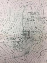
Photos of CC NDB Station for airline traffic prior to IGS era
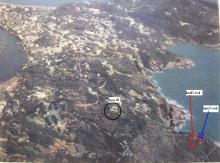
Here are the photos related to CC NDB approach over Cheung Chau island.
Upper Left: the NDB station was Known as the Radar Station (ie House #30 in old European part of Cheung Chau), was the last building on Peak Road west near the lower-right. Air traffics streamed on its left heading the Police Sation on the beachhead of Tung Wan beach, on same direction toward the next Stonecutter NDB approach beacon. Over this leg of flight, airplanes seemed to be going to land on the water of the Tung Wan beach and in descend to landing manuveour. This must be a special experience for many skilful pilots who chose to practice the 'low level virtual landing and go'. The virtual runway is being estimated at about 200' on the left side of the photo. East of the Radar Station is also the area where Laura's Mystery Rock group was found. European Houses #27 and the headland nearby had the best view to watch the passing airplanes.
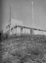
Other photos: Show the CC NDB Station from different views. Its two red and white Barbers poles were clearly standing tall for the passing air pilots. The nice background water is the Nam Tam Wan.
In the early 1970s, a VOR station was set up on the CC's north island, the CC NDB was no more and, since then the Meterological Station moved in . And there is no more landing-wise approach over Cheung Chau. A YouTube video about the 1964 ( ? ) Swissair Convair 990 flight over Cheung Chau is said to be on a VOR/IGS system approach which might have the year wrong, it must not be earlier than 1974 the year equipment began in commission. Ding !
Pls enjoy
Tung
Re: Swissair Videos
There are two parts to the Swissair video of the CC NDB Approach. The year given is 1964 in http://www.youtube.com/watch?v=Ra8eDiqsc4w