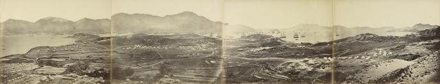
The Kowloon view of the Anglo-French fleet gathering to move on Beijing.
There is another slide to this picture showing Hung Hom to the left.
Key:
A Kellet Island with Jardine Matherson’s East point compound behind
B Morrison Hill
C Signal Hill
D Chinese village in Kowloon – anyone know the name
E Government House
F Marine Police Headquarters Hill
G Green island
H Kau Yi Chau
I Stonecutters Island
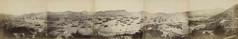
View is opposite direction to this one:
Information on where different regiments were garrisoned:
…The Royal and a Madras regiment at Victoria. At Stanley Barracks about seven miles across the island, the second Batallion of the Sixtieth Royal Rifles. At Deep Water Bay, about halfway between Victoria and Stanley, on the right, Desborough’s and Govan’s Batteries and the King’s Dragoon guards. At Siwan, the military train. And the remainder of the forces at Kowloong
How we got to Pekin p18, Rev R J L M’Ghee
Comments
Village D
Hi Herostratus,
I reckon that Village D in the photo was called “Chowpae” (1845, 1864 & 1889.3), also written “Tso Pai” (1866), “Tso-pai” (1897.1), “Cho-pai-tsoy” (1863 map, Plate 4.1 in Mapping Hong Kong), “Tsopai Chai” (1888.1) and “Tso Pai Tsu” (1910).
I’m assuming that all the above mentioned names refer to the same village as they are all marked in approximately the same location. Also, the dates of the maps overlap, but they each show only one of the various names. Similarly, the 1878 Rates Book for Kowloon villages ( https://gwulo.com/media/33075 ) lists “Tso Pai Chai”, but none of the other possibles.
I think the site of Village D is somewhere near the Kowloon Cricket Club today.
Ref. – all the above mentioned dates refer to the dates given for maps on the excellent website https://www.hkmaps.hk (except for the 1863 map).