This bridge is clear to see on the 1952 map.
Its construction isdescribed in point 140.c of the PWD Annual Report for 1914:
A separate contract for the principal bridge, 182 feet in length, spanning the river at Tai Wo Shi was let to Mr. Lam Woo in May. By the close of the year, nearly the whole of the earthworks had been completed and the whole of the culverts and bridges, with the exception of the principal bridge at Tai Wo Shi and one single-span bridge (25-ft.), had been completed.
After crossing the bridge at Tai Wo Shi, the road runs on a high embankment across the low-lying agricultural land to the north-west. This embankment was originally constructed for the Kowloon-Canton Railway but was abandoned as the result of an extensive re-alignment carried out in this neighbourhood during the progress of the work. It has now been utilized for the road, for which it was well adapted.
I hadn't heard that story of the railway re-alignment before, so it's an interesting snippet. The modern map shows the section of road that headed north-west from the bridge still exists, but it doesn't look to be on an embankment any more. I guess the land on either side of it was raised when that area was first built on.
I've set the dates for the bridge to 1915-c.1957:
- Point 160.b in the PWD Annual Report for 1915 notes that "The whole of the work was finally completed in June".
- I've assumed this bridge was demolished during the construction of the third generation of bridge.


Comments
Why wasn't this bridge blown up in 1941?
Does anyone know why this bridge wasn't demolished in 1941?
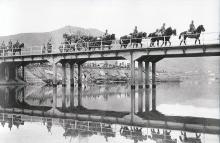
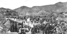
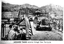
Several photos from 1941 show Japanese troops crossing this bridge, which was still intact.
One of the tasks of the retreating allied troops was to demolish bridges to delay the Japanese advance, so I wonder what caused this one to be left intact.