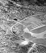
Where Tseuk Luk Street crosses the nullah at Choi Hung Road, the bridge is much wider than is needed for the Street. That's because the bridge was once part of the north-west extension of Runway 13 at Kai Tak airport. (Click to view on the 1956 map above.)
At that time the runway extended across Choi Hung Road (then named "Clearwater Bay Road"), and the traffic had to stop and wait when planes were using this extension!
When the new runway was built out into the harbour, the old Runway 13 was no longer needed, and this bridge is all that remains of it today.
Notes from IDJ:
In earlier years on Gwulo, the Kai Tak runway crossing over what was known as Sai Kung Road or Clearwater Bay Road, but now Choi Hung road was discussed.
Disappointingly, few photographs have surfaced showing this crossing in action. There are only two on Gwulo as far as I am aware.

The ‘poor’ image just posted shows the crossing in operation with an airliner passing over the main road, and lower right, traffic held up as it passes.
Unfortunately, the picture is a ‘screen grab’ from 1950s film stock that later was transferred to domestic VHS tape and recopied an unknown number of times.
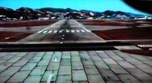
20 years ago, I obtained my VHS copy of the complete documentary film that shows how the new 1958 runway pointing out to sea was designed, developed and built. A very interesting film with many aerial views of 1950s Kowloon, especially of the number of hills and unpopulated areas under the proposed flight path.
Included in the 1958 runway documentary film is this pilot’s view of the short extension that crossed the main road.

What is not clear is how airliners manouvered onto the extension before take-off. Taxi on in a forward direction then turn themselves around or be backed on by an aircraft-tug/tractor?
Closer to the runway’s threshold, the extension appears to have consisted of rectangular blocks, presumably of concrete?

The black horizontal strip is the Tarmac surface of the main road.
If you have any other photos of this extension, we'd love to see them. Here's how to upload a photo.
Photos that show this Place
Comments
Re: Northwest Extension of Runway 13
As I understand, departing aircraft requiring the full length, would enter the runway and make a "one-eighty" by following markings on the ground, like a turning circle, to line-up in the direction of take-off.
From charts of the dual runways at Kai Tak post WW II, one will note the presence of "dumb-bell" shaped areas at the end of the runways. The "dumb-bells" would contain the turning circles for aircraft to safely turn around and align in the direction of take-off.
In the blurry screen captures, the turning circle at the extended north west end of the runway is not visible. Further info here
(Update: The markings on the ground are called nose wheel guide lines. My notes indicate that the markings for aiding pilots in turning in the extension area were first painted in July 1957.)
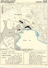
1950 Work on Kai Tak Runway Northwest Extension
China Mail 7 October 1950
"To meet the needs of modern aircraft and the operational requirements of the RAF, the main northwest-southeast runway of Kai Tak Airport is to be lengthened. This necessitates the resumption of a piece of land northwest of Clearwater Bay Road about 165 yards wide and 176 yards in depth.
Once the land has been resumed, the aerodrome runway will be continued right across Clearwater Bay Road into the cleared (resumed) land. A concreted bridge 70 yards wide will be built to span the nullah.
Road traffic along Clearwater Bay Road will have to cross the extended runway. The crossing will be controlled by gates on either side of the runway, similar to the gates of a railway level crossing. Eventually, it is hoped to divert the road so that it will pass the right round the airfield extension, to the north of the runway.
Work on the runway extension has already started within the present boundaries of the airfield."
(Notes: The proposed diversionary road was never completed. However, the bridge across the nullah remains today and is part of Tai Shing Street and Tseuk Luk Street in San Po Kong.)