Photo received by email
Date is a guess
Notes from moddsey:
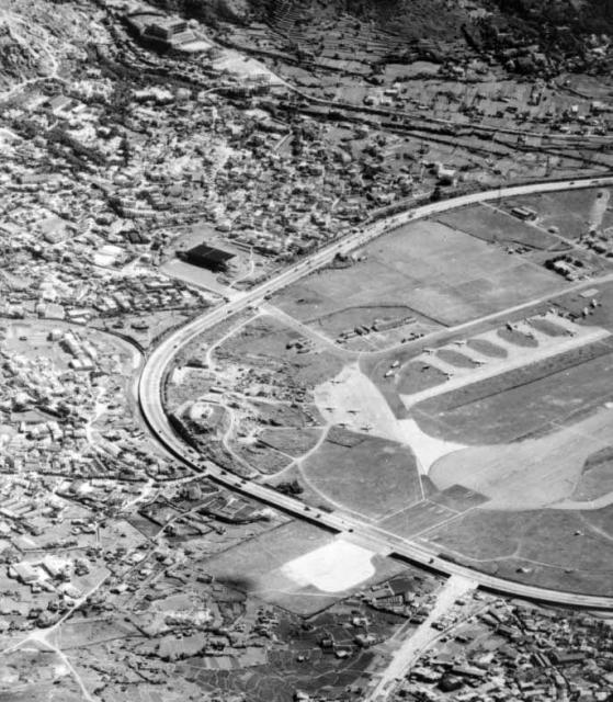
This photo captures the discussion that is taking place. It is an aerial shot of the northwestern end of Kai Tak probably taken after 1954 showing the:
- RAF aircraft parking apron to the north of the airport
- Extension to Runway 13 that was completed in 1950
- RAF hangar at Tai Hom and the access road leading to it
- Diamond Hill squatter area
- Choi Hung Rd and the nullah
- Worn track through Nga Tsin Wai Village that was used by British POW labour to build the paved runways (right of the extended runway)
- Sha Tin Pass Rd (left of the extension)
- Clearwater Bay Rd winding up Customs Pass and
- Good Hope School founded in 1954 (Oldtimer's school)
Date picture taken
1955
Gallery
Shows place(s)
Comments
Kai Tak
Remember it well more especially coming in to land through the mountains over Stinkers corner in a Valleta,no runway out to sea in those day's
Surely someone will remember this experience.
harry
What years were you flying
What years were you flying into Kai Tak harry?
Rgds
J
Kai Tak Airport
Given there are now several major roads in this area, is this road parallel to the runway Kwun Tong Road or Choi Hung Road? or Prince Edward Road which I think did not extend this way until later.
It is refreshing to see how Clear Water Bay Road looked many years ago, and this photo puts me in my school bus as it was travelling uphill. The spacing of the houses on the south side, and their set back from the road, is how I remember them. The walk through Kowloon Dairy (Wai Kee) was serene, free, and playful for this student.
Re: Kai Tak Airport
The ring road entering San Po Kong from bottom right would be today's Choi Hung Road (formerly Clearwater Bay Road)..
Kai Tak Airport
Thanks Moddsey for clearing up my confusion.
Taihom Diamond hill
memon
Kai Tak Airport - Clear Water Bay Road
Greetings. Starting from the top of this photo the first fairly straight line was, still is, Clear Water Bay Road climbing gradually uphill. Next, the dark thick and a bit crooked line was a hedge, and next straight dark line was the nullah which ran under the road to the airport. Whereas the nullah near the runway extension was adjacent to the road, this nullah was a bit remote so not too many outsiders knew of its existance. Today, it must be running below some streets to the sea. Regards, Peter