
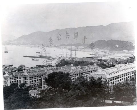
When: The photo was taken in 1902 by R C Hurley [1]. He included it in his book "Views of Hongkong", published the same year.
Where: He was looking west along Praya East. In 1902 that was the Wanchai seafront, today it's called Johnston Road.
What: We rarely get to see views of this part of Hong Kong's seafront, so we can use this chance to learn more about the area at the turn of the century. Whenever I need to know about the history of this area I turn to Carl Smith's "Wanchai: In Search of an Identity" [2], and I'll be quoting from it often below.
I'm also going to use a couple of contemporary maps of this area to help work out what we're looking at:

The top, coloured map [3] is from 1903, and it shows the lots of land together with their lot numbers. As they had access to the sea they were all Marine Lots.
The lower, black & white map [4] is from 1897 and is much more detailed, showing outlines of individual buildings and their street numbers. I've added the red lines to help me match up the maps and the photo. I've linked the edge of a building in the photo to where I think that edge is shown on the two maps. (You can zoom in on the map if you'd like to see more detail.)
Now back to the photo, starting with the building furthest away from us along the Praya.
Methodist Sailors' and Soldiers' Home [5]
We can just see this building peeping out from behind the larger building on the left.

The land appears to be empty on the 1897 map, but occupied on the 1903 map. That makes sense, as the building opened in 1901. Here's a closer view:

The Blue Buildings, 1-4 Praya East [6]
Next come four large buildings known as the Blue Buildings, at 1-4 Praya East. (I'm using the street numbers from the 1897 map.)

They continue the nautical theme: the right-hand pair of buildings was rented by the Royal Navy, and used as their canteen:

5 & 6 Praya East
The photo isn't clear enough to be 100% sure, but it looks as though the building was being demolished when this photo was taken:

7 & 8 Praya East

There are a few questions about the previous two buildings. According to Smith:
"The Sisters of Charity of St Paul of Chartres owned the lots next to the Blue Buildings (ie Marine Lots numbers 23 and 24). On the seafront of their property they built European-style residences similar to the Blue Buildings and leased them in 1863 to Joao Joaquim dos Remedios, a wealthy Portuguese merchant. He, in turn, subleased them to tenants."
The 1897 map shows four buildings along the seafront of these two lots, numbered 5, 6, 7, and 8, Praya East. The building marked "French Convent" [7] on the map occupies the western two buildings, numbers 5 & 6. I'm not sure if they're the same "European-style residences" from the 1860s that Smith describes, or later buildings erected on those sites.
The 1903 coloured map adds to the confusion. It shows Marine Lot 23 (ML23) much wider than ML 24, and with "French Convent" extending across the front of the lot as though it would occupy buildings 5, 6, & 7.
The photo and the 1897 map look more consistent, with the land split equally between the two lots & buildings. So in this case I think there was a mistake on the 1903 map, where Marine Lots 23 and 24 weren't drawn at the correct size. The map was commercially produced, and below we'll see it has at least one other mistake.
|
New Gwulo talk: 17th May 2017 This photo is part of my latest talk, which I'll present for the first time on Wednesday evening, 17th May 2017. The talk is open to the public so please come along if you're free. For more information about the event, and details of how to reserve seats, please visit the RAS website. |
9 & 10 Praya East
These are unusual for being the only single-storey buildings along the Praya.

The 1897 map shows two long buildings running back from the seafront, with a lane between them. I believe the archway in the centre of the facade in the photo was the entrance to that lane. The lane was (and still is) named Li Chit Street, after a member of the family that owned this land.
11 Praya East
This building stood on Marine Lot 29. On the 1903 map the lot is shaded, and is one of the few to have a name attached, "Wanchai Warehouse Co":

12 Praya East

Just in front of 11 & 12 Praya East / Marine Lots 29 & 30, the maps show a short pier. If you'd been here in the early 1870s, you'd have seen a much more impressive pier. Here it is, with a couple of large sailing ships moored alongside:
The pier was 1,000-foot long, built by the Hong Kong Pier and Godown Co [8]. Their godowns (warehouses) occupied the Marine Lots 29 & 30 we've just looked at. The company went bust c.1873, and the pier disappeared soon after - I don't have a firm date for its disappearance yet, but I guess the 1874 typhoon played a part.
13 Praya East
When seen from the sea, this was the only section of the seafront that had a gap in the line of buildings.

Here we're seeing it at an angle instead of face on, but by comparing it with the map we can see it shows:
- a two-storey building, furthest from the camera, numbered "13" on the map
- to the left of it is an open piece of ground, with a crane standing in front of it at the water's edge (we'll talk about the crane more below)
- nearest the camera is another two-storey building, which isn't numbered on the map.
14 Praya East
This is a larger, three-storey building, on the corner of the Praya and Ship Street.

Back to the crane: buildings 13 &14, and the unnumbered building between them, were all built along the seafront of adjacent Marine Lots numbers 31 & 36. Both lots belonged to a single owner from 1856 on, and housed a succession of shipyard, engineering, and blacksmithing businesses. At the time of this photo, George Fenwick owned the land and ran his business here. Smith describes the site:
"[...] there had been a creek running through the lot from which ships were launched. Then the government closed the creek and the drawbridge at the Praya. This forced the company to stop building larger vessels, though small launches were still built and carted across the Praya to the sea. When the Tramway was built on the Praya in 1904 this last measure had to stop also and the company began to transfer their business to a new site in Causeway Bay. In 1911 the company went into liquidation."
So in 1902 they were still building launches here. The crane was likely used to lift the launches in and out of the sea, and to unload materials used in the shipyard and engineering works.
15-22 Praya East
The scene changes again, and the last buildings we'll look at are two short terraces, each made up of four, two-storey houses:

They were built along the seafront of Marine Lot 64 (the coloured map mistakenly labels it number 84). Originally this lot was like the other lots we've seen, belonging to a single company and housing a handful of large buildings. But by 1860 the lot had been re-developed for residential use. Terraces of small houses were built, shown clearly in the photo and the 1897 map.

These houses were a template for how the rest of this area would soon be changing.
Look at the 1903 map again and note the roads, marked in brown. See how few roads there were between Queen's Road East (just off the top of the map) and the Praya? Between Arsenal Street on the right and Ship Street on the left there is only a single, unnamed road (today's Anton Street).
But left of Ship Street are two more roads in quick succession, Tai Wong Street down the middle of the lot, and Tai Wong Lane along its other side. When a lot changed from industrial to residential use, the residents needed easy access to their new houses, so new roads were built.
Soon after this photo was taken, several more of the lots were re-developed and turned into housing, so more of those access roads were needed. The four additional roads across this land that we see on modern maps are Landale Street, Li Chit Street, Gresson Street, and Lun Fat Street. They were all in place by 1920.
I wonder how much of the change to residential use can be traced to the arrival of the trams in 1904? On the one hand the tramlines meant the lots along the Praya no longer had easy access to the sea. That made them unattractive for use as Godowns or by businesses like Fenwick's. Then at the same time the trams improved communications and reduced commute times, making Wanchai more attractive as a residential area. It makes me think of Kennedy Town today, and how the arrival of the MTR has changed it so quickly.
Who
Sailors Home / Naval Canteen / Shipyard / Ship Street. It's not hard to see that the area was popular with sailors!
As well as the working sailors, the photo shows the area was also popular with people who sailed for leisure. We can see several of their boats moored in the foreground, looking very different from the junks and sampans around them.

Just beyond them is a larger pleasure boat, pulled up out of the water on a slipway:

I believe the slipway belonged to Ah King, a well-known boat builder in Hong Kong. Ah King and western-style sailing boats were closely interlinked. First, Ah King's shipyard was known as one that understood the design and construction of western-style sailing boats, so they may have built some of the boats shown here.
The people who sailed these boats got together and formed the Hong Kong Corinthian Yacht Club (HKCYC) [9]. As Stephen Davies has previously noted, that club was also connected to Ah King:
In Gillian Chambers' history of the RHKYC, Eastern waters Eastern Winds, she mentions that the [HKCYC] at one stage early in the game had their clubhouse in a loft over Ah King's boatyard. The reason for this seems to have been that following the shift towards smaller boats that emerged from changes to rules by the Yacht Racing Association in the mid-1890s, Ah King proved a whizz at building the new craft and hospitable to the chaps who sailed them, who weren't part of the affluenza who could afford the whoppers favoured at the HK Yacht Club. Something like that.
Finally, when the HKCYC opened their own club house in 1906, it was "situated on a very convenient spot on Praya East, between A King's slipway and No. 2 Police Station.", ie just off to the left of the foreground of this photo, and a close neighbour of Ah King.
I hope you've enjoyed this look at turn-of-the-century Wanchai. If you can add any other old photos of this area, they'll be very welcome. Also a big thankyou to Janet Hayes, who kindly donated this photo to Gwulo.
Gwulo photo ID: NDA02
|
This week on Gwulo ... Readers ask for help:
New photos, posts & comments:
|
References:
- Robert Crisp HURLEY [c.1848-1927]
- "Wanchai: In Search of an Identity" by Carl T. Smith appeared as a chapter in the book "Hong Kong: A Reader in Social History", published by Oxford University Press.
- 1903 Map of HK Island north shore, original held at UK National Archive, their reference: MFQ 1/1363/9
- 1897 Map of HK Island north shore, original held at UK National Archive, their reference: MPHH 1/412
- Methodist Soldiers' and Sailors' Home (1st location) [1901-????]
- Blue Buildings - Praya East [????-1926]
- French Convent, Wanchai [????-????]
- 1,000-foot Pier at Wanchai [1872-????]
- Hong Kong Corinthian Yacht Club [1906-1920]
Comments
Wanchai Power Station
Originally thought inland was the Wanchai Power Station with its chimney at centre left but it is too far east of Star Street. Chimney, obelisk?
Wanchai waterfront
Dear David,
Splendid analysis, thank you.
My centsworth. As of 1905 until 1910 the Seamen's Institute was housed in Nos 72 & 73 Praya East, which as far as I can work out was quite near to, but possibly east of No.2 Police Station somewhere between Ship St and Swatow St, so not in this photo, sadly.
In May 1909 the foundation stone of the new Seamen's Institute was laid on the eastern edge of ML29, which by the time the foundation stone was laid had been divided into 295 (E) and 296 (W). In house number terms this was severally and in sequence, Nos 8 when the building was first mooted in c.1906-7 (more on this below), then 9 round about the time the foundation stone was laid in 1909, then 21 Praya East when or shortly after the building opened (1910-1911). From an analysis of maps (I could very well have got this wrong), the location of the new Seamen’s Institute would appear to have been on the west corner of the intersection of Praya East and what became Gresson Street, and from the only known two photographs occupying about two thirds of the block from Gresson Street to Tsui In Lane, with the back of the building on an alley.
The building of the new Seamen's Institute was delayed because of a great deal of shilly-shallying over the first and abortive Praya East Reclamation scheme. The original plan for the Institute had been for the temporary premises to be a stop-gap whilst the reclamation scheme got under way. The scheme had first been mooted in 1900 by Mr Chater and Mr Modi and a number of other marine lot holders on Praya East some eight years before the Mission acquired the plot. After some to-ing and fro-ing over detail, during which the proposed reclamation had increased from a 445’ extension to seaward to a 520’ extension, in February 1901, subject to certain conditions, government had given approval. By April the lot holders had agreed to government’s conditions and in August they had sent a letter proposing to go ahead. Then nothing happened.
The reason seems to have been that the lot holders had supposed that the new tramline along the Wanchai waterfront, that eventually opened in 1904, would lead to a marked increase in business and other activity, boosting demand for land and thereby making a reclamation a feasible speculative venture. By 1905, however, it had become evident that the tramline was working no such increase and accordingly support for the project had evaporated. The meeting on 12th May 1905 had been called to get an agreement to shelve the proposed reclamation, which the meeting duly did.
When the Governor had opened the Institute in its temporary premises in 1905, he had affirmed that "a site (on the new reclamation (SD)) shall be reserved, and lent to the Mission on favourable terms...(for) the handsome Seamen’s Church and Institute…worthy of Hongkong’s long and noble lead in provision for sea-going men". So it seems possible that although nothing formal seems to have been done vis-a-vis the Institute until 1909, forward plans may have already had a concept design for the new building on its hoped-for, new plot on the reclamation. Then the reclamation didn't happen and what was needed was somewhere to put the 'handsome Seamen's Church and Institute'. Evidently whatever was available wasn't up to accommodating both, so the new Institute ended up without a church (it never seems to have had one during its lifetime 1910-1933).
So tucked in here, given that Paul Chater was very much in with the Missions to Seamen's Local General Committee and was probably advising them as to land opportunities, is an explanation for what happened to No 9? (&10?) assuming that to have been the low rise building straddling Li Chit St that you mention. The site was ripe for development.
That's unless (the numbering of these things is a constant puzzle) where the Institute was built is where your No.11 stands, which you identify as ML29, though that doesn't tally with the numbering in the Missions to Seamen archives (or the street and lot index), unless we assume that ML29 included Nos.9 & 10, such that No. 11 was on what became ML296 and the building of the Institute on where 9 & 10 stand that by inference became ML295. That's of course, given the house numbering at the instigation of the project, ignoring the possibility that it was built on half the site of No.8 where Carl Smith's European residences seem to have been.
If you can cast any light, that would be wonderful. I have to say that when I first looked at this photo I did a double-take because the building at No.5 & 6 'being demolished' is a dead ringer, in terms of what can be seen of its facade (I have a fairly rough line drawing), to the Seamen's Institute designed by Alfred Bryer of Leigh and Orange (he of HKU's main building) in the 'Flemish Renaissance' style that was in the course of construction in 1909!
Hurley's photo book dating can sometimes be a bit unreliable. Most of his books were privately published and the photos tipped in, so as he ran down stock it is at least possible that photos that had been in the first versions had had substitutes put in by later sales - only a close comparison of the images of all remaining examples could help. My own bibliography of Hurley's work, put together mainly by Jonathan Wattis (who is an authority), has no definitive 1902 HK book. There is the 1897 Jubilee Book. And there is the probable candidate here c.1905 (possibly earlier) The Far East: Sixty pictures. Hong Kong, Canton, Macau, Shanghai, Peking that also exists in a 1908 state.
So I'm wondering whether what we have here is the 1908 Hurley and an image of the new Seamen's Institute under construction on a site that creates even more puzzles than there already appear to be.
Best,
Stephen D
re: Wanchai Power Station
Moddsey, I think you're right that it's the Power Station's chimney, as the chimney should be visible in this photo, and I don't know of any other chimneys around that area. Could it just be the angle of the camera that makes it look too far east?
Re: Wanchai Power Station
i note the Power Station was behind the French Convent. As you say, it may be the camera angle. Thanks.
re: Wanchai waterfront
Thanks Stephen, glad you enjoyed it.
I've posted more information about the book this photo came from, with the supporting details for the 1902 date, at https://gwulo.com/node/37786
"In May 1909 the foundation stone of the new Seamen's Institute was laid on the eastern edge of ML29, which by the time the foundation stone was laid had been divided into 295 (E) and 296 (W). "
I think the sub-division was about splitting the lots north-south, rather than east-west. So the new ML295 was the north part of the old ML30, and ML296 was the north part of the old ML29. Then Gresson Street ran along the boundary between the old ML29 & ML30.
Thanks for the extra information about the first attempt at reclamation, and the effect of the trams on the area. Interesting to read how the delay affected the size & location of the new institute too.
"So tucked in here, given that Paul Chater was very much in with the Missions to Seamen's Local General Committee and was probably advising them as to land opportunities, is an explanation for what happened to No 9? (&10?) assuming that to have been the low rise building straddling Li Chit St that you mention. The site was ripe for development."
Looking at the photos of the 1910 institute, there's this one taken not too long after it was finished:
The low-rise 9&10 from the main photo above are still standing, so their re-development does not look to have been connected with the work to build the Institute building.
"I have to say that when I first looked at this photo I did a double-take because the building at No.5 & 6 'being demolished' is a dead ringer, in terms of what can be seen of its facade (I have a fairly rough line drawing), to the Seamen's Institute designed by Alfred Bryer of Leigh and Orange (he of HKU's main building) in the 'Flemish Renaissance' style that was in the course of construction in 1909!"
I'm guessing that is just a coincidence. The building at Nos 5 & 6 is shown complete in a c.1890 photo (page 55, "The Hong Kong Album" by Museum of History, 1986), so it's more likely to be an older building that was demolished in 1902.
A couple of other thoughts - The difficulty of cross-referencing text records from different years is that the buildings' street numbers change over time. Have you tried using the rate books at the PRO to nail them down? If you look at the same section of road in successive years' rate books, you could follow how the building numbers / owners / lot numbers change from year to year.
And looking at the photos of the 1910 Institute, the last one is a still from the film, the World of Suzie Wong. It could be worth watching the film around that scene to see if there are any better views if a colour view would be helpful at all.
Regards, David
Seamen's Institute
Dear David,
Thank you kindly for that. Very good to have such a firm date for the Hurley album. The bibliography can now be amended to c.1902 or earlier (the earlier just in case).
The image of the Seaman's Mission is excellent; much thanks to Moddsey. I should be most grateful for the detail of the printed source it evidently came from and, if possible, a higher res image. The Mission's history is to be published by HK City U Press this summer, and this would be much the best image to have of the 1910-1933 building. Can anyone read what it says on the low buildings? I can get "...Co. Ltd." but the rest defeats me, though it looks like two words, then "&" and then a long word before "...Co. Ltd."
I think I misled myself not just with fond imaginings and uncertainty about Hurley's album dates, but by confusing the location of the later, 1933-1967 building with that of the earlier building a few blocks eastwards. Thanks for the clarification. My muddle over ML295/296, which should have been enlightened by your earlier steer referencing the long, narrow original ML29, was a consequence of 296 retaining the ML designator, which suggested a water frontage. It appears not. I'll modify my text accordingly.
The A King hunch is almost certainly spot on. The masts of another ketch on a slipway occupy the left foreground suggesting, maybe, that whoever took the photo may have been on the upper floor of the premises where the CYC had its cubhouse. By the by, there is no hard evidence that Hurley was actually a photographer and at least some of the images in the 1902-1908 album (it seems to have had a number of issues) were by identifable other photographers. Finding evidence that Hurley actually took photographs, rather than published books with photographs from unknown sources (for example a book of images of recently occupied Qingdao in 1899, which Hurley amost certainly did not take himself) would be huge plus.
Onto more maritime stuff.
I have some doubts about the crane analysis. True George Fenwick's was in 1902 (and probably before that) at 13 Praya East. In 1896 George Fenwick had died and the business was run by one William George Winterburn. As you note, with the coming of the tramways in 1904 the yard was no longer viable and so it moved to 6 Morrison Hill, Causeway Bay. By 1907 Winterburn’s name had disappeared and the yard was being managed by John Ingram Andrew (a leading Freemason), who retired in 1912 with the winding up of the company once it could no longer compete and had lost its core business. That said, the yard was still building quite large vessels in 1900 (two years before this pic) when it built the two 147', 569grt stern-wheelers Nanning and Sainam for Butterfield & Swire.
So, the crane. It would seem to me that the crane/sheerlegs is to be associated with the river steamer that is in front of it. This vessel is manifestly NOT alongside the seawall, but lying stern-to, either to an anchor (must be the port anchor since the starboard anchor is visible and a'cockbill) or, given your comment about a stub pier, with her port quarter alongside the stub pier.
My hunch would be that she is being worked on by Fenwick's, who specialised in (and originally were focussed on) boiler and engine work. If the ship is moored stern to, then the crane may be a floating crane sitting on a barge alongside the steamer's port side (two legged cranes like this were the most common type of floaing crane at the period). If she's alongside a pier, then the crane is at the end of the pier. It looks to me (see the tall, thin funnel immediately in front of the crane) as though the crane is in position to work heavy machinery (bits of boiler/engine) out through the access hatches above the engine/boiler spaces, when they could be rolled across the Praya to the workshops.
Thanks again.
Stephen
re: Seamen's Institute
Hi Stephen,
The c.1915 image of the 1910 building was added to Gwulo but actually lives on Flickr, so you'll need to contact the owner there:
https://www.flickr.com/photos/79081005@N03/28643267346/in/dateposted/
The name on the low building next door is tantalisingly close, but just not clear enough to read. The Rate Book might help again, as it should give the name of the resident person / company for each building.
Thanks for the extra input on the crane. Looking at the c.1890 photo again, the crane looks to be on the pier as you say. The printed copy isn't clear enough to be 100% sure though, so hopefully a clearer photo will surface at some point.
Regards, David
A. King Slipway
It is now clear that the premises of the boatyard business was always known as A. King Slipway - with the full stop after the A. The founder's funeral in 1936, although calling the found Mr A. King, names his sons as Leung Kwei-wing and Leung Kwei-wah - a descendant, Leung Kwok-chun, was last recorded by Jerry Sousa in the area of the multiply moved yard in 2001 or thenabouts.
By hazard I have stumbled on a pretty firm location for the yard - according to a 1908 advertisement for S. Tashima, Japanese shoemaker at No. 66 Praya East, his premises were "opposite A. King Slipway".
Best,
Stephen D
Wanchai's seafront 1880/1902
Recently, Daniel Wettling posted a photo showing the Wanchai Praya, my guess is about 1880. I've cropped the same area from David's and from Daniel's post to compare both views.
Top photo: Cropped from Early Waterfront.jpg (ca. 1880)
Bottom Photo: Cropped from Wanchai's seafront in 1902
Some houses can be seen on both photos others have been demolished and rebuilt.
The Blue Buildings are already there, right of them no sign of the Sailors & Soldiers Home, so the upper photo is definitely older. 11&12 Praya East houses are on both photos, the ones between these and the Blue Buildings are different. 11&12 Praya East have scaffolds around them, possibly under construction and almost finished. The short pier in front of these buildings is visible on both photos.
Left is Fenwick Shipyard, much more developed on the bottom photo. (for details see here)
Robert Crisp Hurley
Hi everyone, I'm a bit late to this conversation thread, but thought I'd share my new findings with you all on Robert Crisp Hurley. I have to say, I tend to agree with Stephen above, when he says: "there's no hard evidence Hurley was a photographer". I have discovered that Hurley married D.K. Griffith's sister, Matilda. As far as I've been able to establish when Griffith's died in 1897, Matilda and Robert were the only close family in HK. I speculate that Hurley finalised Griffith's affairs and took over his entire stock, images, negatives, equipment etc., and since 1897 was the Jubilee year, royally cashed in. It came at a very fortuitous time for Hurley, and, frankly, who would know whose photos were used. I think it is far more than a co-incidence that Hurley commenced his photographic career in 1897 at the time when he was able to use his well honed wit and charm to pull off such a publication at such a momentous time, using someone else's talent. I dare say, he probably got familiar with the equipment and, perhaps, later images that are attributed to him, really were taken by him, but I truly have my doubts about the Jubilee publication. As Stephen says, it would be good to find some tangible evidence that Hurley did indeed take photographs and not just use images from various unknown sources that he put his name to.
I've written a small blog piece on Hurley and the inter-connected families of Hurley and Griffith. www.chater-genealogy.blogspot.com. "Robert Crisp Hurley: Jack of All Trades, Master of One. Or Was He?"