"Lai Chi Kok Hospital was built between 1921 and 1924 and was originally a prison. In the 1930s, infectious diseases were prevalent and the prison was converted into Lai Chi Kok (Cholera) Hospital and Lai Chi Kok (Relief) Hospital. In 1948 the two hospitals were renamed Lai Chi Kok Hospital (荔枝 角醫院), which was one of the two infectious hospitals in Hong Kong in the period 1946-1975. The other infectious hospital was in Sai Ying Pun. After the opening of Princess Margaret Hospital (瑪嘉烈醫院) in 1975, the role of Lai Chi Kok Hospital as an infectious diseases hospital gradually diminished. It was then used for convalescent psychiatric patients transferred from Castle Peak Hospital ( 青山醫院 ) and leprosy patients transferred from the Leprosarium at Hei Ling Chau (喜靈洲). In 2001-2006, the Hospital was under the management of the Hospital Authority and its funding was provided by the Social Welfare Department. Its name was changed from Lai Chi Kok Hospital to LCKH HACare Home (荔康居) for psychiatric patients. Historical materials show that the hospital site could be related to use as an early immigration post for Chinese labour heading overseas to South Africa. Moreover, there is a stone tablet inscribed with Chinese characters “Gau-Lung Kwan” (九龍關) right next to the hospital cluster. This is similar to the Qing customs station stone tablet found at the old Ma Wan township."
"The old hospital site is comprised of an upper section and a lower section. The buildings under study are all located in the lower section. They are Blocks F, G, H, I, J, K, and Blocks P, Q, W, W2 and N. The first six blocks were used as wards and Block K as an Administration Block. The other blocks were used for various purposes such as quarters, kitchens, offices and stores."
More photos and detailed information about the restoration of the site (carried out between 2009-2014) can be found in the 2017 report, titled "Research Study and Heritage Interpretation of Historic Relics in Jao Tsung-I Academy", here.
Coolies bound for South Africa were encamped at Lai Chi Kok on an "eminence beautifully situated at the rear of Stonecutters Island". Further reading here
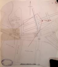
Phil noted that on this map from 1923 (shown below), the site is marked as Lai Chi Kok Camp, but the AAB notes decribe it as "Lai Chi Kok Hospital was built between 1921 and 1924 and was originally a prison.".
I wonder if the buildings are older than the 1920s, and date back to the site's use as a camp holding Chinese labourers who were on their way from southern China to work in South Africa?
The 1904 newspaper article about the camp that Moddsey introduced above includes the text:
Passing on through the temporary camp, after having climbed a steep hill, the almost ideal site selected for the permanent structures is reached. Here a little town is rapidly springing into existence. Buildings are going up on all sides. All of these have been completed almost up to the first floor, and are now waiting for some fittings which have already been shipped from England and are already due in Hongkong, Upon the arrival of these fittings the buildings will rapidly be completed. There are to be ten two-storied houses set apart for the accommodation of coolies, and they will each be 7? feet long by 34 feet wide and will be composed of brick and iron walls with tiled roofs and cement floors. There is a hospital 60 feet long by 18 feet wide and a main kitchen, or cook house, 54 feet by 17 feet, besides numerous other buildings.
The camp shown on the 1923 map has two groups of five buildings, which would fit the "ten two-storied houses" in the 1904 newspaper article.
Thanks David, it's a good point that you've made, and interesting to see the site on the 1920s map. There do seem to be a lot of similarities between the buildings described in the 1904 article and those in the AAB summary (which at least mentions a possible link with the early 1900s use). I wonder what the 'historical materials' were that the AAB referred to - I'll go back to the other links above to check. The brickwork and style of the buildings also remind me of other (similarly functional) colonial buildings from the very early 1900s in Hong Kong, but others are more knowledgeable than me on this. Regards, Liz
"According to the Report of the Director of Public Works in 1908, the government arranged to purchase the whole of the buildings from the lessees of the Transvaal Emigration Depot at Lai Chi Kok for a sum of $3,000 with a view to utilizing them for a quarantine station. The buildings, which were originally built as temporary structure, required a considerable amount of repair and it was also decided to erect a masonry boundary wall to enclose them and to repair the old Customs Station for the use as a guard house." (p.8)
"Using HKD $3,000, the Hong Kong government brought [sic] the site which was the former Lai Chi Kok workers houses from The Chamber of Mines Labour Importation Agency
in early 1908 and turned it into a quarantine station, named as Lai Chi Kok Quarantine Station. The former shabby huts for detaining Chinese workers were refurbished as red brick bungalows. Former custom station was turned into guard house. Walls built from big rocks were erected outside the entire centre. The station was in use for only two years before being abandoned. According to the same segregation camp diagram of 17th October 1905, the building cluster did not differ much from now." (p.35-36)
(The 1905 diagram referred to here, and another 1910 architect's drawing, can also be found in the Report at approx p35-40)
Out of the three "zones" (low, middle, high) that make up the existing site, the "low" zone appears to have the oldest surviving buildings: the customs building (from the late 1800s) and the single-storey red brick buildings (from 1905/ 1910). The 2017 report states on p61: "The building cluster of the low zone was built in 1910. Its double-layer red brick walls were laid in English bond. There was a fireplace in the main building, which might be used by the hospital’s administrative staff and medical staff. Rebuilt from a cluster of huts already there, the buildings have single-layer red brick walls only. Such simple arrangement of brickwork could help expedite construction. It also corresponded to the historical background that the buildings were transformed from huts."
So at a minimum there are several structures that pre-date the 1920s and are still around.
In addition, over 1000 prisoners from the Lai Chi Kok prison and the Victoria prison were to be transferred to the new Stanley prison by March 1937 according to an article in November 1936 ('Gun Battery for Stanley Peninsula')
And by by 1938 works were completed in converting the former prison...
"...alterations and additions to convert the lower blocks at the former Lai Chi Kok Prison into a relief hospital and the upper blocks into an infectious diseases hospital..."
Looking at newspaper mentions of "Lai Chi Kok" or "laichikok" in HKPL, the reader is provided with information that the area/district was considered as a suitable location for the handling of plague patients. In 1894 in pre-New Territories times during the outbreak of plague, mention is made of a "plague hospital" on the Chinese side of the border at Lai Chi Kok. A vist made in 1896 to a matshed hospital can be read here (Hong Kong Telegraph 4 June 1896 refers).
Post 1898, mention is also made of the proposed erection of an observation station and segregation centre for plague patients.
Without a suitable map at hand, the location of these early plague stations cannot be determined.
Page 36 of the 2017 report says that one of the main differences between the camp diagram of 1905, and then after the government aquired the site in 1908, was:
It seems very likely from all of the above, then, that the brick buildings can be dated back to ca 1904 (even if those in the high and middle zones were partly refurbished in the 1920s for the hospital). Prior to 1904 there are likely to have been matsheds on the same site.
The customs station/guard house (constructed of stone) is significantly older, possibly ca late 1880s, as is the boundary stone that is still on site.
I am interested to know where the old stone pier (also dating back to the customs station era or earlier, and in use until ca 1920) would have been located - it is marked on the 1905 'segregation' plan, and is mentioned on p17 of the 2017 report. The area was reclaimed in the early 1920s.
The Jao Tsung-I Academy (JTIA) published another report in 2018, titled "Past and Present Stories of the Site of Jao Tsung-I Academy". It can be found here. It mostly reiterates the findings of the 2017 report.
Title: "N.K.I.L. NO. 12, LAND AT LAI CHI KOK, - OFFICE FOR EMIGRATION AGENT. LEASE OF THREE ACRES FOR ESTABLISHING A SEGREGATION CAMP FOR COOLIES DESTINED FOR SOUTH AFRICA"
Having re-read the 2017 report, it seems to only be referring to the buildings in the low zone when it mentions the 'red brick houses' replacing 'thatched huts'. It states on p.38:
"2. Red brick houses replaced thatched huts. New building cluster in the Low zone. From the 1910 construction plan, one can see the planned appearances of the dormitory, kitchen and hospital were in line with the ones in the present. Such design matched with the remained buildings in the present. This proved foundations of converting the site into a hospital had already been paved during the time when it served as a Quarantine Station."
The elevation plan of one of the buildings in the low zone (1910) on p.39 shows the same building that still stands there today.
Given that the whole site comprises numerous buildings of different ages, and it had several distinct uses over time, perhaps new places need to be created to reflect this. Any suggestions welcome.
Thanks David, I've shifted the date of the pier connected with the Jao Tsung-I Academy (JTIA) forward to 1904, until more information comes to light. Given that there is more than one pier from 1904, I'm not sure which one is being referred to in the JTIA materials. Regards, Liz
Comments
Heritage assessment
The Heritage Assessment for this cluster of buildings (currently Grade 3 status) is available on the AAB website (http://www.aab.gov.hk/historicbuilding/en/845_Appraisal_En.pdf) and states:
"Lai Chi Kok Hospital was built between 1921 and 1924 and was originally a prison. In the 1930s, infectious diseases were prevalent and the prison was converted into Lai Chi Kok (Cholera) Hospital and Lai Chi Kok (Relief) Hospital. In 1948 the two hospitals were renamed Lai Chi Kok Hospital (荔枝 角醫院), which was one of the two infectious hospitals in Hong Kong in the period 1946-1975. The other infectious hospital was in Sai Ying Pun. After the opening of Princess Margaret Hospital (瑪嘉烈醫院) in 1975, the role of Lai Chi Kok Hospital as an infectious diseases hospital gradually diminished. It was then used for convalescent psychiatric patients transferred from Castle Peak Hospital ( 青山醫院 ) and leprosy patients transferred from the Leprosarium at Hei Ling Chau (喜靈洲). In 2001-2006, the Hospital was under the management of the Hospital Authority and its funding was provided by the Social Welfare Department. Its name was changed from Lai Chi Kok Hospital to LCKH HACare Home (荔康居) for psychiatric patients. Historical materials show that the hospital site could be related to use as an early immigration post for Chinese labour heading overseas to South Africa. Moreover, there is a stone tablet inscribed with Chinese characters “Gau-Lung Kwan” (九龍關) right next to the hospital cluster. This is similar to the Qing customs station stone tablet found at the old Ma Wan township."
"The old hospital site is comprised of an upper section and a lower section. The buildings under study are all located in the lower section. They are Blocks F, G, H, I, J, K, and Blocks P, Q, W, W2 and N. The first six blocks were used as wards and Block K as an Administration Block. The other blocks were used for various purposes such as quarters, kitchens, offices and stores."
Detailed research study done in 2017
More photos and detailed information about the restoration of the site (carried out between 2009-2014) can be found in the 2017 report, titled "Research Study and Heritage Interpretation of Historic Relics in Jao Tsung-I Academy", here.
1904 Coolie Encampment at Lai Chi Kok
Coolies bound for South Africa were encamped at Lai Chi Kok on an "eminence beautifully situated at the rear of Stonecutters Island". Further reading here
Racist attitude of the British circa 1904
Camp before prison / hospital?
Phil noted that on this map from 1923 (shown below), the site is marked as Lai Chi Kok Camp, but the AAB notes decribe it as "Lai Chi Kok Hospital was built between 1921 and 1924 and was originally a prison.".
I wonder if the buildings are older than the 1920s, and date back to the site's use as a camp holding Chinese labourers who were on their way from southern China to work in South Africa?
The 1904 newspaper article about the camp that Moddsey introduced above includes the text:
Passing on through the temporary camp, after having climbed a steep hill, the almost ideal site selected for the permanent structures is reached. Here a little town is rapidly springing into existence. Buildings are going up on all sides. All of these have been completed almost up to the first floor, and are now waiting for some fittings which have already been shipped from England and are already due in Hongkong, Upon the arrival of these fittings the buildings will rapidly be completed. There are to be ten two-storied houses set apart for the accommodation of coolies, and they will each be 7? feet long by 34 feet wide and will be composed of brick and iron walls with tiled roofs and cement floors. There is a hospital 60 feet long by 18 feet wide and a main kitchen, or cook house, 54 feet by 17 feet, besides numerous other buildings.
The camp shown on the 1923 map has two groups of five buildings, which would fit the "ten two-storied houses" in the 1904 newspaper article.
Earlier origins
Thanks David, it's a good point that you've made, and interesting to see the site on the 1920s map. There do seem to be a lot of similarities between the buildings described in the 1904 article and those in the AAB summary (which at least mentions a possible link with the early 1900s use). I wonder what the 'historical materials' were that the AAB referred to - I'll go back to the other links above to check. The brickwork and style of the buildings also remind me of other (similarly functional) colonial buildings from the very early 1900s in Hong Kong, but others are more knowledgeable than me on this. Regards, Liz
Earlier origins continued
(Extracts from the 2017 report, link above)
"According to the Report of the Director of Public Works in 1908, the government arranged to purchase the whole of the buildings from the lessees of the Transvaal Emigration Depot at Lai Chi Kok for a sum of $3,000 with a view to utilizing them for a quarantine station. The buildings, which were originally built as temporary structure, required a considerable amount of repair and it was also decided to erect a masonry boundary wall to enclose them and to repair the old Customs Station for the use as a guard house." (p.8)
"Using HKD $3,000, the Hong Kong government brought [sic] the site which was the former Lai Chi Kok workers houses from The Chamber of Mines Labour Importation Agency
in early 1908 and turned it into a quarantine station, named as Lai Chi Kok Quarantine Station. The former shabby huts for detaining Chinese workers were refurbished as red brick bungalows. Former custom station was turned into guard house. Walls built from big rocks were erected outside the entire centre. The station was in use for only two years before being abandoned. According to the same segregation camp diagram of 17th October 1905, the building cluster did not differ much from now." (p.35-36)
(The 1905 diagram referred to here, and another 1910 architect's drawing, can also be found in the Report at approx p35-40)
Varied uses over time
Again, the following information is taken from the 2017 report referred to above:
Sham Shui Po Customs Sub-station(1895-1899)
Labourers’ Quarters(1904-1906)
Lai Chi Kok Quarantine Station(1910-1912)
Lai Chi Kok Prison(1921–1937)
Lai Chi Kok Infectious Disease Hospital(1938–1975)
Lai Chi Kok Psychiatric Rehabilitation Centre (1975 – 2000)
HACare Home (2000 – 2004)
(Although the report mentions a military camp nearby in the 1920s, it seems to be referring to a slightly different location.)
Buildings in "Low zone"
Out of the three "zones" (low, middle, high) that make up the existing site, the "low" zone appears to have the oldest surviving buildings: the customs building (from the late 1800s) and the single-storey red brick buildings (from 1905/ 1910). The 2017 report states on p61: "The building cluster of the low zone was built in 1910. Its double-layer red brick walls were laid in English bond. There was a fireplace in the main building, which might be used by the hospital’s administrative staff and medical staff. Rebuilt from a cluster of huts already there, the buildings have single-layer red brick walls only. Such simple arrangement of brickwork could help expedite construction. It also corresponded to the historical background that the buildings were transformed from huts."
So at a minimum there are several structures that pre-date the 1920s and are still around.
Lai Chi Kok prison to hospital
The Lai Chi Kok prison was damaged in the August 1936 typhoon
In addition, over 1000 prisoners from the Lai Chi Kok prison and the Victoria prison were to be transferred to the new Stanley prison by March 1937 according to an article in November 1936 ('Gun Battery for Stanley Peninsula')
Source: Hong Kong Telegraph, page 7, 16th November 1936
And by by 1938 works were completed in converting the former prison...
"...alterations and additions to convert the lower blocks at the former Lai Chi Kok Prison into a relief hospital and the upper blocks into an infectious diseases hospital..."
Source: 1938 Public Works Department Report
References to Lai Chi Kok between 1894-1901 in HKPL
Looking at newspaper mentions of "Lai Chi Kok" or "laichikok" in HKPL, the reader is provided with information that the area/district was considered as a suitable location for the handling of plague patients. In 1894 in pre-New Territories times during the outbreak of plague, mention is made of a "plague hospital" on the Chinese side of the border at Lai Chi Kok. A vist made in 1896 to a matshed hospital can be read here (Hong Kong Telegraph 4 June 1896 refers).
Post 1898, mention is also made of the proposed erection of an observation station and segregation centre for plague patients.
Without a suitable map at hand, the location of these early plague stations cannot be determined.
Brick two-storey huts date to 1904 not 1908-10
Page 36 of the 2017 report says that one of the main differences between the camp diagram of 1905, and then after the government aquired the site in 1908, was:
"1. Red brick houses replaced thatched huts"
If that refers to the ten huts marked A-E in the high zone and G-K in the middle zone (see https://www.jtia.hk/wp-content/uploads/2019/05/jita_leaflet_20190118-1…), then I think it is a mistake as the 1904 newspaper report shows the buildings were already made of brick, not thatch.
Dating of buildings
It seems very likely from all of the above, then, that the brick buildings can be dated back to ca 1904 (even if those in the high and middle zones were partly refurbished in the 1920s for the hospital). Prior to 1904 there are likely to have been matsheds on the same site.
The customs station/guard house (constructed of stone) is significantly older, possibly ca late 1880s, as is the boundary stone that is still on site.
I am interested to know where the old stone pier (also dating back to the customs station era or earlier, and in use until ca 1920) would have been located - it is marked on the 1905 'segregation' plan, and is mentioned on p17 of the 2017 report. The area was reclaimed in the early 1920s.
Revitalisation documents
The discussion paper for the LegCo Public Works Sub-Committee, showing plans for revitalisation of the site in 2010, can be found here
Another report on site history
The Jao Tsung-I Academy (JTIA) published another report in 2018, titled "Past and Present Stories of the Site of Jao Tsung-I Academy". It can be found here. It mostly reiterates the findings of the 2017 report.
Lease for labour camp purposes in 1904
Government Records Service record ID number: HKRS58-1-24-70 (forms part of the HKRS58-1 C.S.O. Files in the Land Office)
Title: "N.K.I.L. NO. 12, LAND AT LAI CHI KOK, - OFFICE FOR EMIGRATION AGENT. LEASE OF THREE ACRES FOR ESTABLISHING A SEGREGATION CAMP FOR COOLIES DESTINED FOR SOUTH AFRICA"
Date: 31.3.1904 - 20.5.1908
Buildings in 'low' zone
Having re-read the 2017 report, it seems to only be referring to the buildings in the low zone when it mentions the 'red brick houses' replacing 'thatched huts'. It states on p.38:
"2. Red brick houses replaced thatched huts. New building cluster in the Low zone. From the 1910 construction plan, one can see the planned appearances of the dormitory, kitchen and hospital were in line with the ones in the present. Such design matched with the remained buildings in the present. This proved foundations of converting the site into a hospital had already been paved during the time when it served as a Quarantine Station."
The elevation plan of one of the buildings in the low zone (1910) on p.39 shows the same building that still stands there today.
Given that the whole site comprises numerous buildings of different ages, and it had several distinct uses over time, perhaps new places need to be created to reflect this. Any suggestions welcome.
Old stone pier(s)
The maps at https://www.hkmaps.hk/mapviewer.html that show this area clearly:
pier(s)
Thanks David, I've shifted the date of the pier connected with the Jao Tsung-I Academy (JTIA) forward to 1904, until more information comes to light. Given that there is more than one pier from 1904, I'm not sure which one is being referred to in the JTIA materials. Regards, Liz
History
The whole history of the site is available on site.
Go pay a visit.
Jao Tsung-I Academy