Opposite view to this Panorama, same date: https://gwulo.com/media/25852
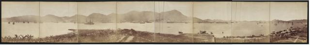
Taken from the Water Police Station in Tsim Sha Tsui.
Soure is Probably National Archives UK
Date picture taken
1879
Gallery
Shows place(s)
Comments
Old Kowloon Peninsula
Hello, can anyone explain this panoramic in detail. Through hours and hours of research I understand most of it, but cannot place the newly built road that dead-ends at the boulders, slightly left of center foreground. Is it possibly the beginnings of Canton Road, but maybe not as originally Canton Rd, the path and the lamp post all merged at the waters edge and this appears to parrallel the path. The path ran from Middle Rd western end at a 45* angle to Canton Rd. Could it be the pathway to the Ball-drop Tower, not built quite yet? One key factor is the remnents of the old fort foundation, drawn on an 1841 map. Thank you for any help! Willy
Canton Road - Early Years
Hi wcfreeman, I tried to match the two roads on this panoramic with the roads in the 1903 Map - http://www.hkmaps.hk/mapviewer.html . It appears to me that the road closer to the western water has similar alignment and location as the current Canton Road. The other near-parallel road (foreground) does not match any of the present roads, but I am "guess-estimating" it was about the same spot as the current Hankow.
On the white spot between the two roads and behind the hill, I think it was the cleared land just north of the Police Barracks in the 1903 map. This is a crude investigation and I welcome any corrections. Regards, Peter
Re: Photo
The timeball tower (first generation) can be used as a reference for the boulders in the foreground of the original photo.
Old Kowloon Peninsula
Hello Peter, this 1903 map originated in Dec 1886 from an Admiralty Chart, which are still in business today making charts. It has an enormous amount of detail including trees marked on the foot path that fits well with the panorma. In the panorama everything is west of the foot path, both Hankow & Ashley road can be seen immediately west of Victoria View on the chart, but ended at Middle Rd and the beach was not developed yet. Standing at the Base of Signal Hill the Marine Police Station lines up perfectly with Middle Road today. More to come...
Old Kowloon Peninsula
Thank you wcfreeman for the feedback. It is the same one I was looking at, and your research is well ahead of mine. Looking forward to reading more. Regards, Peter
Old Kowloon Peninsula
Thank you moddsey, I read a lot of your post and take them to be somewhat gospel, always accurate! This was time stamped 1908 and I believe this person to be standing on Canton Rd with Salisbury just in front of her. In 1903 the beginnings of the Kowloon Beach reclaim was under way, to the east of the foot path, by 1904 it was gone! Salsbury Rd west was now underway as well.
Thank you Peter, the very
Thank you Peter, the very reason why we do this here, it creates an exillerating chat for everyone to chine in! Never feel slighted about what you post, I too learn every time. Willy
Old Kowloon Peninsula
Moddsey I'm still baffled about that road to the boulders! Was it put in just before the timeball tower to create building access or was it a changed road plan or maybe a changed plan of access the Marine Police Station. As stated in the title the photo was taken "1879 from the station", this would be only months away from the new station of 1881. As a possible north / south road it appears to have a center median in place. A fellow history buff friend of mine has educated me on panoramas, these earlier captures tended to give the illusion of a wrapp-around appearance and distort the lay of the land slightly. This particular capture clearly shows MPS generation one and the remainder of the hill still intact. It also shows the beginning of Middle Rd running the length of the beach and Nathan Rd on a 90* to it, leaving the beach going north. The second generation MPS appears to have been built slightly behind gen one, and no timeball tower as yet, leading to the possibility of an access road guestamation, in the panorama. I welcome a challenge! Willy
Kowloon's Early Peninsula
Thank you Willy. I enjoy joining in these discussions, and always accept corrections with gratitude. Regards, Peter
Re: Old Kowloon Peninsula
I think it was an access path to the police station. Views of the police station here Actually, the second generation Water Police Station was occupied in 1884 as noted here
In Cantonese parlance, 1884 does not sound auspicious. Thus, "1881 Heritage" was used to name the entire area as a hotel and shopping landmark.
As I understand, the early paths and trails in Tsim Sha Tsui were mainly for military use. It would appear they were later developed to form the initial road system in Tsim Sha Tsui. The landscape changed in the 1880s after Kowloon Wharf had built their godowns, Star Ferry provided a service to Kowloon Point and more lots of lands were sold.
Old Kowloon Peninsula
I have always maintained paths, become dirt roads, become paved and eventually major thuroughfairs. In other words their location does not change much at all, this helps to identify surrounding land features and its overall progress. Thank you for the corrections, you have given me a feast of new information, I will be wallowing in this history for many hours. Thank you again moddsey. Willy
Old Kowloon Peninsula
Stumbled upon some interesting photos which I hope will create a further discussion. First of all the uncropped version of this lady. This reveals a whole new perspective! She is standing on Macdonnel Rd south almost at the praya but the date appears incorrect compared to the 1905 capture. The Police HQ ramp is in place, Salisbury Rd does not appear to have been started yet, the trees on the road are small a newly planted with support baskets, and the Sharp & Co building behind her is not there yet. All of this compared to the 1905 photo. I have added a screenshot from 1886 showing The Path, Macdonnel (now Canton Rd) the ramp entrance to Police HQ, timeball tower and the praya as it was in 1886. Willy