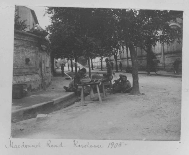
Interesting photo of pre-Canton Road. Note the road sign: Macdonnell Road. Is that the steep road on the right leading up to the former Marine Police Headquarters?
Interesting observations by moddsey. But, if that is the slope up to the Marine HQ, then I am trying to figure out whereabouts this junction is - I always thought the slope up to the Marine Police HQ (on that side of the complex) was closer to Salisbury Road area...It seems too far back for this to be the junction with Salisbury Rd.
Is it possible that the road sign is slightly misaligned and the photographer is on is actually standing on Canton Road looking down what is now Peking Road, and the distant slope was a rear road entrance...(I have no idea if it even had one)...?
In this 1902-1903 map of TST at: https://gwulo.com/media/11438, Macdonnell (Canton) Road is extended southbound past Salisbury Road. Perhaps this is the location of the photographer. If this is correct, then the steep slope would be the access path/road to the Marine Police Station.
I think the three-storey building is the grey square on the map. To its left are long buildings running from the seafront up to the junction with Salisbury Road, which I guess is the wall we see in the photo. You can see them bottom-centre in this photo, the three-storey building with two lower, gabled-roof buildings on the left:
The road which runs parallel to the Western Praya at Kowloon Point, on the eastern side of Marine Lots Nos, 9 10, 11, 20, 21, 21a and 22e shall henceforth be known as and designated MacDonnell Road. Hong Kong Daily Press 4 September 1887 refers.
Comments
Re: Photo
Interesting photo of pre-Canton Road. Note the road sign: Macdonnell Road. Is that the steep road on the right leading up to the former Marine Police Headquarters?
Canton Road
Interesting observations by moddsey. But, if that is the slope up to the Marine HQ, then I am trying to figure out whereabouts this junction is - I always thought the slope up to the Marine Police HQ (on that side of the complex) was closer to Salisbury Road area...It seems too far back for this to be the junction with Salisbury Rd.
Is it possible that the road sign is slightly misaligned and the photographer is on is actually standing on Canton Road looking down what is now Peking Road, and the distant slope was a rear road entrance...(I have no idea if it even had one)...?
Re: Canton Road
In this 1902-1903 map of TST at: https://gwulo.com/media/11438, Macdonnell (Canton) Road is extended southbound past Salisbury Road. Perhaps this is the location of the photographer. If this is correct, then the steep slope would be the access path/road to the Marine Police Station.
canton Road
nice find moddsey, it looks like it fits. Is there anywhere that tells us what the building was on the opposite side of the road?
Re: Canton Road
Some references were made to a 3 storey building probably owned by Kowloon Wharf at https://gwulo.com/node/8529 Perhaps that is the building.
Good detective work!
Good detective work!
Here's the map that Moddsey mentioned:
I think the three-storey building is the grey square on the map. To its left are long buildings running from the seafront up to the junction with Salisbury Road, which I guess is the wall we see in the photo. You can see them bottom-centre in this photo, the three-storey building with two lower, gabled-roof buildings on the left:
1890s Map of Tsim Sha Tsui, Kowloon
MacDonnell Road, Kowloon
The road which runs parallel to the Western Praya at Kowloon Point, on the eastern side of Marine Lots Nos, 9 10, 11, 20, 21, 21a and 22e shall henceforth be known as and designated MacDonnell Road. Hong Kong Daily Press 4 September 1887 refers.