The modern building in the background looks familiar. Does it also feature on the left of the next but one photograph? Could it have been taken on Queen's Road East looking towards its junction with Hennessy Road? (Andrew S)
Date picture taken
1953
Gallery
Shows place(s)
Comments
Re: Queen's Road East\Hennessy Road\Queen's Way
Hi There,
This should be Queen's Road East. The photo may have shown the original Monmouth Path where a sign with an arrow is pointing to it. Was that the Rodney Block at the back?
T
QRE
Probably the former Rodney Block. This photo may tie in with the Whitty Street tram photo.
Hi T and Moddsey,
Hi T and Moddsey,
I have just located Monmouth Path on Google Earth. I had never heard of it before but it does tie in quite nicely with the area where I expected this photograph and the tram one to have been taken. The building which you suggest was probably the Rodney Block reminds me of the area on the North side of Queens Road East, but checking on my own photogaphs of that area I see that by 1957/8 when I was there a huge block of police flats had been built, so my memory is probably at fault. On which side of which street was the Rodney Block?
Best wishes Andrew
Re: Rodney Block
Rodney Block was on the north side of QRE (today’s Queensway). It was west of the Police Married Quarters in Arsenal Yard. As mentioned here: https://gwulo.com/atom/16404 , it appears that Rodney Block may have been the former Wellington Barracks in its previous guise as it housed the “golden clock”. Need to check on this later.
Thank you Moddsey. It's good
Thank you Moddsey. It's good to know that my memory of over 60 years ago is stilll reasonably intact. What a pity I didn't choose to load cheaper black and white film into my camera and take many more photographs. I guess that, then, I didn't understand historical perspective and just took so many interesting (now) buildings and places for granted. Hindsight is a wonderful thing! Seeing your photograph '1950s Queensway' gives my memory quite a nudge and I can almost see my pals and I walking down that street.
Mind you, I don't recall the tram tracks having that big bend in 1957/8. I think that Rodney Block is on the extreme left of my 1957/8 photograph below.
Best wishes, Andrew
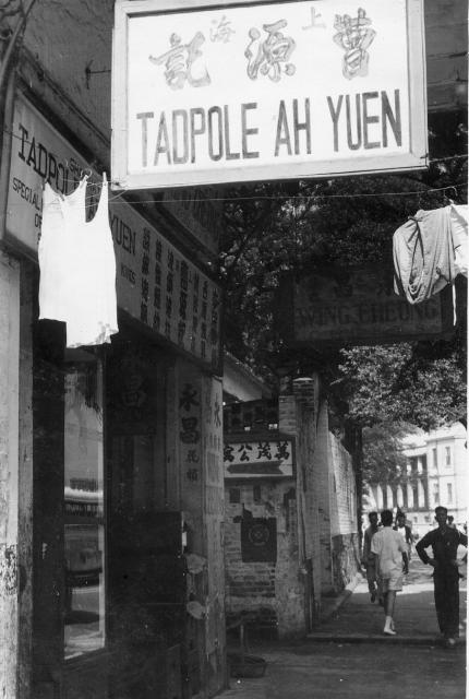
Tadpole Ah Yuen is an unusual
Tadpole Ah Yuen is an unusual name. I'll keep an eye out for it appearing again.
Chi Wo Street near Jordan area
It looks like Chi Wo Street looking north with South Kowloon Magistracies at the end.
Hi ymsitt,
Hi ymsitt,
An interesting thought. You could be correct. My only doubt is whether Peter Keeley ever went as far into Kowloon as Chi Wo Street. Living at Little Sai Wan in the far North East of the Island we tended to stay on the island or go over occasionally to the Tsim Sha Tsui area. I guess that the real clue to the location of the Tadpole Ah Yuen shop is the impressive building just visible at the bottom right of Peter's photograph, which does look like the South Kowloon Magistracies building on Google and Google Earth Streetview. In that case the image should not appear in the same context as those taken by me on Queens Road East near the old police flats and Arsenal street.
magistracy?
Chi Wo Street is located a touch too far west to be able to see this angle of the magistracy, so unless Chi Wo Street used to run through the centre of the DGS grounds, then it's not there. Also the magistracy has a different window configuration at the corner of the building compared to the one in Andrew's photo.
Hi Phil,
Hi Phil,
I have a strong feeling that Peter Keeley's photograph must have been taken somewhere on the Island or possibly somewhere in or close to Tsim Sha Tsui - but I cannot recall any buildings like the modern one shown in the distance on his photograph. I guess that it is possible, but unlikely, that the facade of the building could have been changed between 1952/3 and some date in the 2000s when Google Street View was filmed.
On a different thread - On 7 October, Beylogan, contributed, "I believe it [R.A.F. Little Sai Wan] was blown up in Jackie Chan's Police Story Part Two". I have now ordered a DVD of that film and am hoping(!) that my long quest is going to be fulfilled. I'll let you know if it is the case. Best wishes, Andrew
Re: Maybe the Rodney Block?
Hi There,
Maybe that was the Rodney Block on Queensway, which mean the photographer was likely on Queen's Road East. The I found this link with a similar building:
http://www.weshare.hk/uploads/12155/gJdaUbcv9S1RWBaJjNnKCw.jpg
T
Hi Thomas. Yes that is a
Hi Thomas. Yes that is a possibility. In that case the old building containing the Tadpole Ah Yuen shop must have been on a narrow street all of which were demolished to make way for the modern looking three storey building that looks to be part of a Naval or Army compound opposite to the older one that you think might have been the Rodney Block. Any thoughts?
Tadpole Ah Yuen & Hostel sign
Tadpole Ah Yuen (left half of the shop front) specialized in ball equipment, specifically in repairing rackets, ball nets, ball pillars, it also custom-made fine steel wire ball nets. Maybe there were some tennis or badminton courts in the area. Wing Cheong (right half) sold wooden chests.
The hostel sign with an arrow pointing into the alley seemed to have a street address on the arrow, but it's a bit too blurry.
Re: Photo Location
I think Thomas has got the area correct with his first thoughts. In the original photo, the suggested location of the photographer is on Queen's Road East near Monmouth Path looking towards today's Queensway. In the distance, one is looking at this building (Rodney Block has been mooted) on the right below.
Address of hostel
I found in 1953 Hong Kong Yearbook of Wah Kiu Yat Po/Overseas Chinese Daily News the address of hostel 萬茂公寓 as follow:
15 Monmouth Terrace, Kennedy Road
I hope it helps.
It has just dawned on me that
It has just dawned on me that a photograph that I took in 1958 includes the spot where Peter Keely stood a few years earlier to take his photograph that includes the Tadpoloe Ah Yuen shop sign. First is the enlarged cropped area and second is the original. I'm hoping that the enlargement gives a bit better resolution than is visible on the original. I think that the Monmouth path must have been more or less behind the man in white clothes. Andrew
Monmouth Terrace
ymsitt,
萬茂 is a phonetic transliteration of Monmouth
This section of a 1950s map
This section of a 1950s map recently uploaded by Herostratus in a different thread is intereting. if the copy below is unclear, the original is very good. One of the old naval / military buildings within the dockyard complex and just North of Queens Road is probably the one just visible in the background of Peter's photograpoh. Nelson, Howe, Wardroom and Blake are possibilities. Any thoughts? Andrew
Re: Blake?
Hi Andrew,
Based on the new map and the point of view from QRE, I suggest it is likely the one marked as 'Blake'. I don't know what that is though. Owing to my age I have only seen the Rodney Block in the same location before it was demolished to make way of MTR Island line.
T
Hi tngan,
Hi tngan,
I tend to agree. Blake, as the most Easterly of the several blocks on the map, does seem to be the likely one. Perhaps some of the very old photographs or maps showing the blocks in the days of the Wellington barracks might shed more light on it. Andrew
We've got a page for the
We've got a page for the building marked 'Blake' at https://gwulo.com/node/38533 that has several more photos of it.
Thanks David,
Thanks David,
Yes, I think the block is very probably the Blake block as shown in the centre of this photograpoh loaded by Moddsey.
Presumably, the building just visible on the extreme right of this photograph stood where the police married quarters stood at the corner of Arsenal street in the 1950s. Does anyone know what that building was?