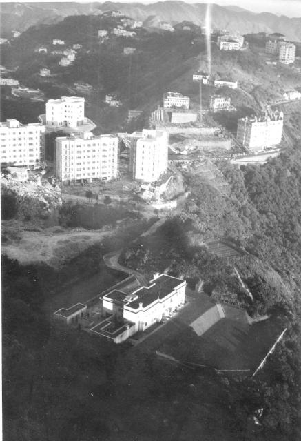
Looking roughly to the East from the roof of the single storey Batty's building. I think that the large area of demolition must be where the old Peak hotel had been. Any suggestions what the other buildings were? I believe that Martin Booth described how he and his parents lived in one of the three modern Government apartment blocks on the left. (Andrew S)
The image below, copied from my own gallery '1957-8 Andrew Suddaby's photographs', which would really be better shown beneath several of Peter's other photographs, shows all the buildings associated with the R.A.F. Batty's outpost as they were in 1958 or a bit later.. It should help to show the relative positions of the various close-ups that Peter took from the roof of the original R.A.F. building, which was probably the single storey right hand part of the final building on Ken's photograph. Peter was there just a year or two before Ken,and the perimeter fence shown on some of Peter's photographs did not enclose the trangle of land where the two small buildngs (including the dark roofed Victorian one) and old circular signal mast platform are.

Comments
Battys c.
Hi Andrew,
Thanks for posting all these very interesting pics taken around The Peak.
This one seems to have been taken from a similar spot to this 2014 view.
It was taken from the most south-easterly of the small hills located at the top of Victoria Peak. Google Maps labels it as "Victoria Peak Transmitting Station".
Yes both the site to the left of Peak Mansions where the Peak Hotel had stood and the Government quarters where Martin Booth lived (Mount Austin Mansions) can be seen.
The building in the foreground is, I think, on RBL 11. I'm not sure how many buildings have stood on that site over the years. According to the 1924 map the building was called Craig Ryrie, No.13 The Peak, at that time, but on a mid-1950's map in my possession it's called Mackinnon House.
It's also interesting to note that both Victoria Ridge and Formosa were still standing (just above the Peak Hotel site) when Peter took this photo sometime between 1952 and 1955.
Battys c.
Hi Andrew,
Just to clarify in case what I wrote above concerning the location where this photo was taken from isn't clear.
The hill in question is shown in Peters other pics here...
"Battys f." ( https://gwulo.com/media/32458 ) - this is the north side of the hill, with Mt Stenhouse on Lamma Island in the beckground.
"Battys from lower down road" ( https://gwulo.com/media/32459 ) - the hill is the one on the left.
Hi Geoff, 'Peak Transmitting
Hi Geoff, 'Peak Transmitting station' was possibly in the 1950's just another way of 'describing' the R.A.F. outpost, known to us as 'Batty's'. In my own gallery, '1957-8 Andrew Suddaby's photographs', (within the 1950s gallery) there is an excellent aerial photograph given to me by my late friend Ken Sly who was the Officer Commanding the R.A.F. Batty's outpost. He was also a seasoned World War II and versatile pilot and used one of the small Auster planes to keep up his flying hours. The photograph, was actually taken by a colleague to whom Ken had, I believe, given a flight to show him what the Peak looked like from the air. It shows all the buildings associated with the outpost as well as most of the rest of the Peak summit. I've added this aerial view to several of Peter's photographs. It will help to show where various buildings and crowds were. Best wishes, Andrew
Battys c.
Hi Andrew,
I think we may be talking at cross purposes. The hill from where I think Peter took "Battys c" isn't in your "RAF Batty's 1958" photo, but is out of sight on the left.
Hi Geoff,
Hi Geoff,
I agree with you about the angles, but I've been looking at the map on Gwulo (Map by ESRI) and I cannot see an obvious hill that would be sufficiently high to achieve the same view that would equal the one from Batty's, that is fairly close to where he worked. Peter would have taken most of these photographs during a break or before or after finishing his shift. I think it's a bit unlikely that he would have climbed to that other hill top when he could have taken the same or a very similar photograph from Batty's. Puzzling?! If you are sure about Peter's standpoint, are you able to put a pin on the map so that we can link the photo with it? Best wishes, Andrew
Battys c.
Hi Andrew,
I've taken your advice and made a "place" for the "hill" at https://gwulo.com/node/44530.
I haven't linked it as a "place" to the "Battys c" photo as "places" tend to be used to identify locations that appear in a photo, rather than the location where a photo was taken from (although sometimes they are one and the same).
Recently I've been enjoying the Aberdeen pics you've been posting. Thanks for all your effort.
Hi GW,
Hi GW,
Apologies for confusing you with somebody else! I take your point about ‘place’ usually being used for places shown and not from where they are taken. Perhaps it would be better if I mentioned the photographer’s standpoint, if I think that I know it, in my initial comment? Best wishes, Andrew
Battys c.
Hi Andrew,
No probs on my side - although Geoff might be offended!
Yes, I think your way of doing it works best.