Mount Austin (i.e. the massif within the loop of Lugard and Harlech roads) has a number, I would say four, of slightly lower peaks in the immediate vicinity of its summit. None of these subsiduary peaks have distinguishing names as far as I am aware, which can lead to confusion when attempting to identify or describe specific locations ontop of "The Peak".
This "place" marker is for the most south-easterly of these subsiduary peaks.
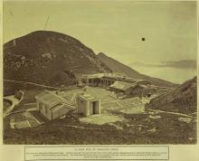
Here's an early photo showing the west side of the hilltop in question with a leaning flag pole ontop and Mount Kellett and Lamma Island in the background.

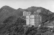
And secondly, the east side of the hill (i.e. the hilltop on the left of the photo).

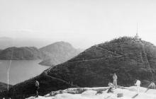
When I last visited, in about 2016, the very top of the hill was fenced off and occupied by aerials. Nevertheless, the path to the top of the hill is in good condition and there are fantastic views from it and around the fenced area. Today Google Maps labels the site as Victoria Peak Transmitting Station.
Photos that show this Place