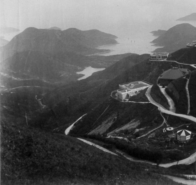
Well spotted, that's the earliest view of one we've seen yet. I think the dark-coloured building above the tank, on the right edge of the photo, is Clavadel. If correct, that brings the date of the photo forward to 1893 or newer.
The white house below Clavadel (on part of RBL 6) on the slope is RBL 297 known as Lysholt (previously Leigh Tor). In the 1970's Lysholt was the Chief Justice's residence. In the 70's Clavadel's address was 19 Gough Hill Road, while Lysholt's was 18.. I believe Lysholt was the Chief Secretary's residence in 1941.
Just to the left of the octagonal water tank is a round structure with a rectangular hole in its top. The 1912 Peak Map (https://gwulo.com/atom/13074) marks both structures with circles.
Extract of 1912 Peak Map, by gw
The round structure is labelled "Well", whilst the octagonal water tank is labelled "Top (illegible words) Tank". I suppose it makes sense to position a water tank next to a well.
Another tank is shown near the top of the extract map, labelled "No.4 Tank Top Water Level 1523". Perhaps both tanks were part of the same early communal water collection and distribution system.
I can't find the octagonal water tank in Moddseys photo in any other maps, but this pic seems to show part of it near the bottom right corner. It's dated 1910 on Gwulo, but between 1890s and 1923 by the source.
72. The rapidly increasing population of the Hill District which depended entirely on the yield of a few shallow wells for a water supply demanded attention in 1888, and previous to Mr. Price’s departure he submitted a proposal to pump water from the Albany service reservoir, but no definite project was put forward prior to Mr. Chadwick’s arrival in 1889.
73. Mr. Chadwick submitted with his report, dated 30th January, 1890, a definite project for supplying the Hill District with filtered water.
74. This project involved—
(a) The pumping of water up to the Peak from the Pokfoolum service reservoir. (b) The removal of the cast iron tanks, situated in the Glenealy Valley, previously used for the water supply of the City but no longer required, to the Hill District.
(c) The laying of a 3-inch rising main from the Pumping Station to the Peak.
(d) The laying of distributing mains throughout the District.
77. The principal dimensions of the engines and pumps are as follows:—
Diameter of Cylinder, Inches.
Diameter of Pump
Length of
Displacement of
H. P.
I.
L.P.
Rams Inches
Revolution, Inches
Pumps per revolution, gallons
6
9
14
2 3/4
18
0.773
78. The maximum height to which water is pumped is 1,780 feet above Ordnance Datum.
79. Water Tanks.—Six cast iron tanks have been erected in the District, viz., at the Peak and Mount Gough of 5,000 gallons capacity each, and at the Peak, Mount Kellet, Plantation Road and Magazine Gap of 10,000 gallons capacity each.
80. Mains.—Five and one-third miles of water mains have been laid in the Hill District; these are of wrought iron varying from 3" to 1 1/2" diameter.
81. The rising main from the Pumping Station to the Peak is of hydraulic piping fixed together with screwed socket joints, and is 4,390 feet in length.
82. These works were completed in 1891 at a cost of $32,585.00.
So the tank in the photo could be the 5,000 gallon tank referred to at Mount Gough above. Also, there are several more to be seen.
A good clear view of the well and the tank. I read that "Lai Fong died on 19th April 1890", so if the "1893 or later" date for the photo is right, maybe it came from the studio that continued under his name after his death.
I have been looking for the other tanks in the peak district, perhaps a few other survive. The 1912 map is not great but the 1924 map (This version is better than the overlay due to distortion from the terrain) clearly shows a few of the tanks
From David's post above:
79. Water Tanks.—Six cast iron tanks have been erected in the District, viz., at the Peak and Mount Gough of 5,000 gallons capacity each, and at the Peak, Mount Kellet, Plantation Road and Magazine Gap of 10,000 gallons capacity each.
2 tanks on the peak: On the 1924 there is something that could be a tank on IL 621 next to the waterworks bungalows. I have not found a photo of the area and it is not accessible on street view.
Mount Kellet: - There is clearly a tank just off the summit labeled service tank. If not removed before I assume this was demolished when Mount Kellet was flattened. There is also a well marked just before the entrance to Matilda Hospital
Mount Gough - On the 1924 map on RBL 133 there is a tank labeled No 4 Service tank. The shape is square meaning it may not be the original cast Iron Water tank. Cannot find any pictures of the location
Plantation Road - The one in moddsey's photo. Does not seem to be there anymore
Magazine Gap. There is a 'No 6 Service Tank' between Severn and Barker Road near GL 24. This area has not been developed so its possible the tank is still there but would involve clambering over the hillside to find its remains. Helpfully there is a government slope as access from Barker Road....
Comments
Well spotted, that's the
Well spotted, that's the earliest view of one we've seen yet. I think the dark-coloured building above the tank, on the right edge of the photo, is Clavadel. If correct, that brings the date of the photo forward to 1893 or newer.
Yes, David & Moddsey, dark house definitely is Clavadel.
Thanks for this photo, Moddsey.
The white house below Clavadel (on part of RBL 6) on the slope is RBL 297 known as Lysholt (previously Leigh Tor). In the 1970's Lysholt was the Chief Justice's residence. In the 70's Clavadel's address was 19 Gough Hill Road, while Lysholt's was 18.. I believe Lysholt was the Chief Secretary's residence in 1941.
Regards, Graham (aka ole_vet)
Water Tank
Just to the left of the octagonal water tank is a round structure with a rectangular hole in its top. The 1912 Peak Map (https://gwulo.com/atom/13074) marks both structures with circles.
The round structure is labelled "Well", whilst the octagonal water tank is labelled "Top (illegible words) Tank". I suppose it makes sense to position a water tank next to a well.
Another tank is shown near the top of the extract map, labelled "No.4 Tank Top Water Level 1523". Perhaps both tanks were part of the same early communal water collection and distribution system.
I can't find the octagonal water tank in Moddseys photo in any other maps, but this pic seems to show part of it near the bottom right corner. It's dated 1910 on Gwulo, but between 1890s and 1923 by the source.
Cast Iron Tanks at the Peak
There are a couple of mentions on pages 10 & 11 of the Report on the Water Supply from 1896:
The Peak Water Works Project.
72. The rapidly increasing population of the Hill District which depended entirely on the yield of a few shallow wells for a water supply demanded attention in 1888, and previous to Mr. Price’s departure he submitted a proposal to pump water from the Albany service reservoir, but no definite project was put forward prior to Mr. Chadwick’s arrival in 1889.
73. Mr. Chadwick submitted with his report, dated 30th January, 1890, a definite project for supplying the Hill District with filtered water.
74. This project involved—
(a) The pumping of water up to the Peak from the Pokfoolum service reservoir. (b) The removal of the cast iron tanks, situated in the Glenealy Valley, previously used for the water supply of the City but no longer required, to the Hill District.
(c) The laying of a 3-inch rising main from the Pumping Station to the Peak.
(d) The laying of distributing mains throughout the District.
77. The principal dimensions of the engines and pumps are as follows:—
78. The maximum height to which water is pumped is 1,780 feet above Ordnance Datum.
79. Water Tanks.—Six cast iron tanks have been erected in the District, viz., at the Peak and Mount Gough of 5,000 gallons capacity each, and at the Peak, Mount Kellet, Plantation Road and Magazine Gap of 10,000 gallons capacity each.
80. Mains.—Five and one-third miles of water mains have been laid in the Hill District; these are of wrought iron varying from 3" to 1 1/2" diameter.
81. The rising main from the Pumping Station to the Peak is of hydraulic piping fixed together with screwed socket joints, and is 4,390 feet in length.
82. These works were completed in 1891 at a cost of $32,585.00.
So the tank in the photo could be the 5,000 gallon tank referred to at Mount Gough above. Also, there are several more to be seen.
Re: Cast Iron Tanks at the Peak
Thanks David. Good find and follow-up.
I found another copy of this
I found another copy of this picture, credited to Lai Afong, at a higher detail and with more to the right:
A good clear view of the well
A good clear view of the well and the tank. I read that "Lai Fong died on 19th April 1890", so if the "1893 or later" date for the photo is right, maybe it came from the studio that continued under his name after his death.
I have been looking for the
I have been looking for the other tanks in the peak district, perhaps a few other survive. The 1912 map is not great but the 1924 map (This version is better than the overlay due to distortion from the terrain) clearly shows a few of the tanks
From David's post above:
79. Water Tanks.—Six cast iron tanks have been erected in the District, viz., at the Peak and Mount Gough of 5,000 gallons capacity each, and at the Peak, Mount Kellet, Plantation Road and Magazine Gap of 10,000 gallons capacity each.
2 tanks on the peak: On the 1924 there is something that could be a tank on IL 621 next to the waterworks bungalows. I have not found a photo of the area and it is not accessible on street view.
Mount Kellet: - There is clearly a tank just off the summit labeled service tank. If not removed before I assume this was demolished when Mount Kellet was flattened. There is also a well marked just before the entrance to Matilda Hospital
Mount Gough - On the 1924 map on RBL 133 there is a tank labeled No 4 Service tank. The shape is square meaning it may not be the original cast Iron Water tank. Cannot find any pictures of the location
Plantation Road - The one in moddsey's photo. Does not seem to be there anymore
Magazine Gap. There is a 'No 6 Service Tank' between Severn and Barker Road near GL 24. This area has not been developed so its possible the tank is still there but would involve clambering over the hillside to find its remains. Helpfully there is a government slope as access from Barker Road....
Water Tank
When I walked along Barker Road, I found one of the octagonal water tanks just east of 8, Barker Road. It's below Barker Road, and still in use.
Great find Klaus!
Great find Klaus!