Just in front of the annotation "Stolzeweels" is the buidling "Modreenagh". This was the first building of its name and belonged to HK Telephone Company. My father was billeted there in the 1920's as a batchelor. It was destroyed during the war and rebuilt as 118 & 119 The Peak. My family and I lived at 119. Opposite was - and still is Jardine's Bridge. 118 & 119 were demolished in the 1960's to make way for a block of flats (Modreenagh No 2) which have also been demolished and rebuilt as Modreenagh No3. I imagine still HK Telephone Co?? To the right was the Peak Club now the site of The Peak School - I merely had to cross the road to get there from the back gate which still exists!
Hi Peter, the name written on the map should read Stolzenfels. It's a place on Gwulo, an early 1880 image is http://gwulo.com/atom/17248. Possibly Modreenagh is left of it.
Comments
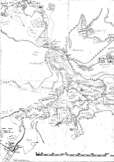
1912 Peak Map
This version of the 1912 map streches out more to the east that the version above.
Sketch map of the Peak 1912
hi, I originally posted this and the addition to Wanchai Gap area as two parts.
I am looking at the original. The handwriiten notes were done by my father as this sketch was in his HK parafinalia.
rgds
Just in front of the
Just in front of the annotation "Stolzeweels" is the buidling "Modreenagh". This was the first building of its name and belonged to HK Telephone Company. My father was billeted there in the 1920's as a batchelor. It was destroyed during the war and rebuilt as 118 & 119 The Peak. My family and I lived at 119. Opposite was - and still is Jardine's Bridge. 118 & 119 were demolished in the 1960's to make way for a block of flats (Modreenagh No 2) which have also been demolished and rebuilt as Modreenagh No3. I imagine still HK Telephone Co?? To the right was the Peak Club now the site of The Peak School - I merely had to cross the road to get there from the back gate which still exists!
Stolzenfels
Hi Peter, the name written on the map should read Stolzenfels. It's a place on Gwulo, an early 1880 image is http://gwulo.com/atom/17248. Possibly Modreenagh is left of it.
Regards, Klaus
Modreenagh
Peter, thanks for writing in. There's a page about that site with a couple of photos at:
http://gwulo.com/node/5125
Regards, David