Photo courtesy of Elaine Schramm, nee Buuck. She writes:
I've seen both #28 and #29 for that house number so not sure exactly which one it is. Zieglers were right next door I believe.
We have a photo for #29 showing a very different style of house (see http://gwulo.com/node/12774), so this may be #28.
Date picture taken
1940s
Gallery
Shows place(s)
Comments
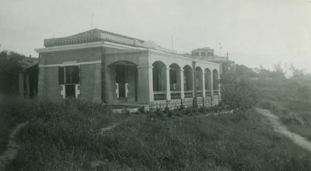
European House #28 on old Cheung Chau
Hello folks,
At first glance it is a bit strange to me that the House seems to be in other part of the south island. My first thought would be a bungalow on the hill of Fa Peng area near House #15 or so.
However, after doing my homework I found more. It is quite likely the #28 House in the Fairy Well area. Together with Houses #29 ( 1937-41: The Zeiglers ) & #27A, they formed a nearest neighbour triangle on this hilly terrain.
You can see my explanation on ' European House #27, #28 and the one MacPherson lived on 1919 Cheung Chau ' on the gwulo.
Also the two photos in the ' 1930s Cheung Chau' could be combined together for better analysis on the Houses' relative position.
When I was very young ( the mid-1950s) my family would have a walk once a while, on the Peak Road and decided to visit friends along the area. At Fairy Well, there lived the Ma's family ( one of the few cross-cultured on CC ). The Ma's residence could be even closer to #28 House then. Due to limited access, we rarely went beyond that point even though we know few more western-styled bungalows were there.
I have checked on the photos related to the #27 House many times and verified it based on my memory on the local geography.
As for this photo, the house behind would likely be the #27 House in the pre-WWll time. The same location with a newer replacement was better shown on photo given by 'Gordon670'--1959 Cheung Chau --a view from the island Harbour, putting most of other houses at Fairy Well hidden.
There were several other European Houses of similar style on the other hills. However most of them were being robbed as the Japenese invasion took destructions against the property of the non-axis nationals.Still I remembered an European House remained fairly well intact because it hoisted a Swiss flag. Those rebuilt or repaired after the WWll had a different look...like the flat roof-top instead of the triangle.
In the mid-1950s one must enter or walk along the #27 site to gain access for this exclusive area. For much of the area between the two houses in the photo had become densely forested with coniferous trees. So #28 House would have been grossly ignored from sightseeing on the Peak Road. The wrap-around path by the #30 House ( the Radar Station )--- via the #29 House ( which could be just an empty or ruined site in my time)--- was truly unknown to us. Local kids did know for sure that the popular, greenish edible gooseberries were quite plentiful in the area.
From the map information of the location of #27A site it seemed to be just below the hill where stood the House #29. That explains the MacPherson House was on the #27A site, on the cliff head overseeing the westend of Nam Tam Wan.
I am glad to be able to understand all this now for it belongs to my childhood surrounding. So many good memory. We also went out to collect stamps in the area by knocking on their door just like few other kids did, we often able to add some more to our collections.
Tung
re: European House #28 on old Cheung Chau
Hi Tung,
Thanks for the identification. I've added houses 27 & 28 to the Places Shown.
Regards, David
A look from the old CC harbour
Hi David,
I hope my homework would bring forth nice memory of some who once enjoyed the beauty and friendship here. They never go away from our minds. Here is a photo of interest too:
www.hkmemory.hk/collections/hkplaces/AllItems/images/201107/t20110722_4…
This photo also shows the #27, #28, #30 Houses and possibly a hidden #29 ( it was on the southern slope off the #30 House) , on top of the Fairy Well hills in distance across the Harbour. The area was not much forested as shown in the 1930s. #28 House was clearly seen only the upper half due to lower and beyond from the ridge. And #30 House stood at the top which is locationwise same as the later-dated Radar Station replacement.
Off the slope from the European Houses, you can also see some of the row houses of the CLCY village at the foothill headland just above the shoreline houses. There were numerous boats of different types in the Harbour. One cannot smell the strong oder of fishy atmosphere now.
The open field at the far right was where we kids flied our kites and watched aeroplanes fly-by or let-down in close encounter, both of these exciting kids' delight continued till the mid-1970s due to more housing sprung up there and a change of flight path to Kai Tak Airport.
I have been actually working on a melody ( The Harbour's Song ) to express this beautiful scenario in the past.
What a precious view!!!
Enjoy your tea!!!
Tung
House #15
Hi there,
I was in the area earlier today (28th June) and I think House #15 might have been demolished quite a while ago. Only the foundation remains. The site was fenced off so I was unable to go near the foundation. The two red road side signs of 歸元精舍 on Fa Peng Road still exist though.
I remember reading a certain Island District Doard member petitioned to turn #15 into a private columbaria. Don't know if this is the case.
There are a few ruins in numbers 14A & 14 on the opposite sides. Maybe #13 too.
Thanks & Best Regards,
T
ps. Tung, the house looked like one of the present day Salesian Retreat Houses. But the one I saw has an upper floor. But the ground level looked very familiar.
House #15 on old Cheung Chau
Hello,
Your suspicion of the Salesian Retreat being below the House #15 area is quite ok, but the House #28 is not in the same region of Nam Tam Wan shoreline. Carefully checking main photo the land between the house and the one in distance it shows there lies a well-cared field, near the right border of the picture. This alone is not the case on Fa Peng. Secondly this field is consistent with today's field by south side of the Xavier Retreat Camp high on the Fairy Well headland region. Remember it was told that the Zeiglers were neighbours there in the 1930s...
During mid-1950s......
My memory of House #15--the Kwai Yuen Jin Seh was at its prime time. A very beautifully-built oriental residence of certain tranditional religious depicts with flowering garden at every quarter. It seemed to be a retirement home for the very rich Chinese retirees to stay both short term and long term. At my time, I really didn't know what the house's business was.
Sometimes we dared to walk through the property and the seniors didn't bother about our trespassing. As we went further down over the slope of grasses and rocks there was a big empty muddy field by the east end of a fairy long European house ( Can't remeber its name). One can identify this field on some qwulo photos of 1930s Cheung Chau. The House did bear some similarity with other European Houses. We didn't feel much activities going on as seen from the outside. Occasionally we met a couple of polite westerners dressed in church wardrobe.
It was the time before the Jockey Club Funded Charity did their expansion. This part of hill was steep and rolling, quite barren, mostly grassland with patches of firs and pines here and there. Along the east runs several cliff heads with few more Houses outstanding. The view was wide and far as it can be, nicely overlooking from the east across the southwest bounded by the water of Nam Tam Wan.
During the early 1960s, more big buildings were appearing, including the Caritas on top of the hill near Chi Ma Hung . The contractor actually built a pier on Nam Tam Wan for the transport of materials by barge over the cove water, totally bypassing the long route through the Harbour village. The pier was finally destroyed by typhoons as it was constructed not meant for the long term.
The changes we see today is pretty big. Hard to find a clearing for a better view of the surrounding. Among the dense overgrown there are houses in ruins and vacanted for decades thats probably because mostly families and their descendents have settled down overseas as none would like to be a lonely housekeeper here. But if you choose to stay on the island there must be for some very good reasons......maybe the air , sunlight, car-less , sea bleeze, ....even the people too. Again ,would one willing to stay on the island forever ?
Regards,
Tung
New Discovery again !
Hello,
I always try to see more from the photo and it works well again.
The background construction that is---- The famous # 27 Houses.
As seen on other 1930s Cheung Chau Photo, we know #27 actually had two Houses on its Lot already. But then this photo is showing at least one of them is undergoing great changes.
How do I know the background has two building not one? Think about the odd appearance if it was just one. The style was really in scrutiny. There was significant wrong if a bungalow had a second floor of different design. Also pay attention to the problem of size proportion with distance.
The one in distance, its ground was relatively higher, was in the process of turning into a bigger rectangular block of one or more likely two floor apartment. The windows were without frames and panels Yet its final shape was consistent with 'gordon670 photo's 1959 Cheung Chau'. This distance apartment in the photo surely did not reveal the final appearance since it was stll under construction.
The next one nearer was still having a bungalow style. It located on the same spot of the present day's Xavier Retreat Centre.
All three buildings ( including #28) were having some distance separating from each others. But the photo's view seems to hide away all that spacious distance.
If I am right then this Photo alone can be very misleading!
Regards,
Tung
Buttressed walls
This picture of #28 shows the buttressed walls of the building very well, the sturdy pillars, as well as the masonry added to the roof against the typhoon season. Shuttered windows and doors. It's a very solid build.