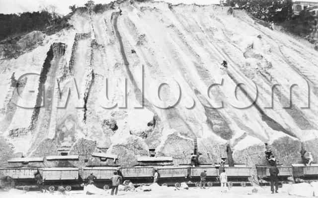
What: The men are digging away Morrison Hill, so that the rock and soil can be dumped in the sea to form the large 1920s Wanchai Reclamation.
Given the scale of the project, it's remarkable to see the excavation is done by hand. Here's a man working at the top of the hill, digging away with his pick:

The rock and soil runs down a channel, and ends up in this temporary silo at the bottom of the slope. They've cleverly left a wall of rock at the bottom, with V-shaped holding areas. The one in this photo is blocked with a couple of boards:

Under the boards is a long plank, stored flat along the rock wall. And just below that you can see a groove cut into the rock, just above the lip of the truck.
Over to the right, we can see what these are for. They take the plank down and slot it into the groove. Then the retaining boards are removed, and the soil pours out. The plank makes sure all the soil ends up in the truck, instead of falling down the gap between truck and rock.

When the trucks were full, they'd run along tracks laid next to the Bowrington Canal, then out onto the reclamation area where they'd be emptied out.
Who: The side of each truck is painted with its number, and the contractor's name: "Sang Lee".

The company is introduced in the document "Praya East Reclamation Scheme. Final Report." [1]:
In 1921, a Contract [...] was awarded to Messrs. Sang Lee & Co., whose tender was the lowest at $2,397,323.00 [...]
Sang Lee & Co. are mentioned in most years' Annual Reports for the Public Works Department between 1900 and1940. They must have been one of the largest contractors of the time to take on a project this size.
Where: I'll go with Morrison Hill as the site, based on the information above. However Sang Lee & Co. worked on many projects, and other construction projects also used railway trucks to move building material. If you think the photo shows another location, please let us know in the comments below.
Morrison Hill covered a large area, so can we narrow it down any further?
If you look at the close-up photos if the trucks, you'll see there are several large wooden pegs sticking out from the rock face. Usefully for us, they cast a shadow. We can see the sun was high in the sky, and that the pegs point towards the sun - so somewhere between southeast / south / southwest in direction.
I guess the photographer was on the old section of Queen's Road (previously called 'The Gap') roughly opposite where Wanchai Park is today. He was looking north towards Morrison Hill, where they're excavating northwards towards the sea. The railway trucks would run east to the right of the photo, down the hill to Bowrington Canal, and out onto the reclamation.
One clue that may help confirm this - there's a building visible on the top of the hill. It isn't very clear, but can anyone recognise it?

When: Probably the early 1920s. The report [1] again:
When the Contractor had been operating for about 1 1/2 years large crops of boulders appeared in the faces of the cuttings, the removal of these boulders not only added considerably to the expense of obtaining filling but slowed down the rate of progress to such an extent that to maintain progress consistent with completing the work within Contract time, it was necessary for the Contractor to operate late into the night. Conditions gradually became worse and the Contractor reported in March, 1924, that he was unable to carry through the work at his contract rate of $0.23.
(The government eventually ended up paying a bonus of 76% to enable the Contractor to complete the work.)
There isn't any sign of the 'large crops of boulders' in this photo. I'll guess it was taken before they appeared, around 1922.
Lots of guesses! If you can add any more facts to the story, please leave a comment below.
Regards,
David
References:
Reference: EC003
Comments
Excavation of Morrison Hill
I wonder whether this might be East Point Hill, a little further east, which used to be owned by Jardine Matheson & Co. and was sold in 1924 to Mr. Lee Hysan for $3,850,960? The house on top of the hill was the Taipan's House. At the foot of the hill(which is now Hennessy Road and was originally the Eastern Praya) were the Jardines godowns, offices, stables etc. After the hill was removed new streets were laid out, including Hysan Avenue and neighbouring streets which were all named after people or places related to the Lee family (Lee Garden Rd., Sunning Rd, Yun Ping Rd, Hoi Ping Rd. Pak Sha Rd etc).
I am sure Jardines must have later regretted their decision to sell off this prime real estate, even though it might have seemed like a good deal at the time.
Incidentally, the main entrance to the driveway which led up the hill to the Taipan's house is now the entrance to the Jockey Club at Beas River, Sheung Shui.
re: Excavation of Morrison Hill
I don't think it's East Point Hill. I haven't heard of the railway trucks used over at Leighton Hill. Also a map in Mapping Hong Kong (plate 3-5a) shows Morrison Hill with the label "in course of demolition 1929", but the buildings are still shown on Leighton Hill. But if you could match up the photo of the building, that would be different!
regards, David
Re Morrison Hill
Just wondering, if the photo is of Morrison Hill would the building on the hill be connected with Hospital Hill?
Morrison Hill
On second thoughts I agree with you that this must be Morrison Hill. East Point Hill, although sold to Lee Hysan in 1924 with the understanding that the government would buy the rock and soil for the Wanchai reclamation, remained standing until the 1950s. The hill, including the houses of the no.1 and no. 2 Taipans, was turned into a garden, hence Lee Gardens.
Regards,
Michael
Morrison Hill
Michael, thanks for the extra information.
Moddsey, that's a possibility. Any chance anyone has the photo from the 1924 aerial survey that shows this area?
Axel wrote in by email and noted it was odd that the house hadn't been demolished before the excavation began. Good point - was the excavation going to stop before it caused any damage to the house?
Regards, David
Memories of Morrison Hill
By email from Barbara Anslow:
When I first went to Hong Kong with parents and sisters in 1927 (I was 8 then), for a time we rented rooms in a large old house in Happy Valley area, I think the road was called Wanchai Road. Morrison Hill was just behind that house.
Coolies, men and women, worked on M.H. all day, chipping away at it, and laying dynamite charges. At noon, and again about 5pm, each working day, loud gongs would be sounded to warn workers etc. to get out of the way, then the charges would be fired - much to the interest of us children. We would see bits of stones flying up in the air, and often one or two would land beside the house.
I had a friend who lived on the other side of Morrison Hill, and I sometimes climbed over it as a short cut to my friend's house.
We returned to UK in 1929, but went back to HK in 1938 when I was surprised to see that Morrison Hill was still there - in fact in 1940 we moved to a flat just a stone's throw opposite it.
Development of Crown land at base of Morrison Hill
In September 1911, my grandfather, Charles Warren, put in an application to the DPW to buy an area of Crown land at the base of Morrison Hill adjoining the northern part of the Wong Nei Chong Recreation ground for the building of houses. The DPW's terms included the construction of substantial retaining walls to prevent landslips that the cutting away of the hill to level the site might cause, as well as provision for the disposal of storm water at the purchaser's expense. The only one of the nine terms contested by Warren was the premium of 40 cents per square foot which he claimed "would not give an adequate return on the outlay that the large amount of cutting would require." In the extract of his letter cited, he states:
My clients are all working men who in consequence of the enormous rentals which are being asked for at present desire to have a home of their own at reasonable cost. It is proposed to build 15 houses fronting Morrison Hill Road in the first instance, for the 15 working men, who are my clients, and the class of houses which would be built would meet a long felt want.
In his preamble presenting the application, the DPW mentions local feeling about Government sale of land around the Valley permitting building to the detriment of the scenery and proposes that a larger scheme of town-planning should be undertaken. I wasn't able to find out whether Warren's request for a lower premium was granted by the Governor. Presumably his application did not relate to the precise area shown in David's photo of the 1920s Morrison Hill excavation.
I would be interested to know what was understood by the term "working men" in 1911 and what section of Hong Kong society Warren, (himself from a humble background), felt was being unfairly subjected to high rents. His SCMP obituary of 12 years later mentions that he would be remembered for his work in connection with the Ridge building scheme at Broadwood Road, "which provided a number of residents with their own dwellings." Helping people to ownership therefore seems to have been one of his causes, but I haven’t been able to find out whether his Morrison Hill project came to fruition.
re: Development of Crown land at base of Morrison Hill
Hi Jill,
That's an interesting connection. Do you know if he successfully bought the land & developed the houses?
I'm not sure exactly who he'd describing as "working men". They should be long-term residents if they were thinking of buying. If he did buy the land, you could work backwards by identifying the lots, and then doing a land search to see who the first owners of the buildings were.
I haven't read them, but the results of this search show several that mention housing problems around that time, and might give you some more clues.
Regards, David
Plan for 15 houses for "working men" to purchase (Morrison Hill)
Hello David,
Unfortunately 2 items are missing from this file C.S.O 5091/11 - It kicks off in September 1911 but the DPW's last letter to the Governor on the matter is dated 8th May 1912. He writes that he is attaching a plan on which the lot in question is coloured red. This is missing and no lot number is given. He finally asks for instructions as to how to reply to Mr Warren's letter. The Governor's reply is not included.
My impression is that Warren's request may have been turned down, as I found later correspondence dated 10th October 1913 about the possible extension of the Recreation Ground and construction of streets which would have to be submitted to Sir Robert Jardine - also a plan (C.O.129/403) that may relate to the same area as Warren's application. Perhaps the DPW's suggestion of a broader town plan was taken up. My next stop would have to be the Land Registry, but I'm not armed with the relevant lot numbers. As mentioned in his obituary, it's possible that my grandfather transposed his application to build houses for 'working men' to what is now Broadwood Road, but which I think did not exist under that name at the time. I've raised this mystery before. It will obviously need more time to solve.
I wonder if 'working men' was a euphemism for 'working class men', as surely everyone up to the Governor was working. Warren would have placed himself in this category and may have found the British class hierarchy that operated in Hong Kong very irritating.
Thank you for the link to questions of Hong Kong housing. I will keep looking. It seems that Charles Warren had done his sums quite accurately if Sang Lee overran his budget on the cutting into Morrison Hill!
Land under Morrison Hill
A search for morrison at HKGRO turned up an auction on 17 Jun 1912 for Inland Lot 1918, "At the base of Morrison Hill". However I didn't find anything that shows who bought that piece of land.
Regards, David
1913 auction for land at the base of Morrison Hill
The date and the location certainly match up with Warren's application. Usually there's a record of auction results in the newspapers, but my previous searches haven't thrown up his name in connection with this one. The correspondence suggests that Sir Robert Jardine (in England) became involved with the development of the larger area. Referring to a communication of 29 September 1913 "with reference to the area known as Morrison Hill" there is mention of a "large area required for the extension of the Recreation Ground and construction of roads." There is a note that the plan is to be returned to the owner of ML 84 "on completion of cutting down of the Hill". It was probably hoped that this would be completed much more quickly than it actually was.
Manual digging to remove hillsides
The system of working up a slope using steps and feeding spoil down a channel was used up to the mid 1950s, to my knowledge. Men and women worked on them. There used to be a hill the length of the KGV grounds on the side facing Argyle street. It had 2 or 3 WW11 tunnels in it and an ack ack (bofor) dugout on the E end which the national Service Gunners used to deploy to during training. In the early 1950s they started building flats for military families on that side of Argyle St and lorries backed up to the bottom of each run and the spoil fell into them. When they were building the "new" runway in Kowloon Bay the same system was used to remove much of the hill on Nga Tsin Wai Rd, (next to 3 eight story tower blocks known as the "Bank Flats; the hill was behind no 162 Nga Tsin Wai Rd") and place it into the bay. They fenced off the road through Kowloon City to keep the lorries running 24 hrs a day, with foot and road bridges over the fencing. The influx of refugees from China provided cheap labour to man the system. The lines of steps left when work paused made climbing the steep slopes easy, except when you slipped and slid down, when it was difficult to break your fall.
Photo of Bank Flats
The Bank flats at Nga Tsin Wai Road can be viewed here I think there is also a photo in the gwulo archive of lorries transporting spoil for the Kai Tak reclamation.
Excavation of Morrison Hill