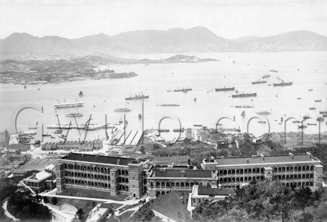
What: Lots to see, but let's start with the obvious, the long building stretching across the foreground of the photo...

... the former British Military Hospital up on Bowen Road.
It opened in 1907, and it's still here today - I hadn't realised it's passed its 100th birthday already!
In the main photo it all looks spick and span, as it had just been finished. The lack of people, plus the scaffolding on the small building to the left, makes me think it isn't open for business just yet.
That small building on the left, still in scaffolding, will be the Nursing Sisters Quarters. Next to it is the main building: North Wing on the left, Administrative Block in the middle, and South Wing to the right. The small building up the slope in the foreground is marked simply "Barrack Block". Note the bench seat on the lawn in front of it. Must have been a nice spot to sit in the evening.
Wanchai
Above the hospital at the right of the picture we can see the rooftops of Wanchai. The only buildings that stand out are the four gables of the Blue Buildings on the seafront. They housed the Royal Naval Canteen:

On their left you can see a distinct gap. It's the line of Arsenal Street, and marks the boundary between civilian Wanchai to the east, and the military land to the west.
Another hospital?
Below the gap is a long building on the top of a small hill. On this 1856 map it is marked as "Native Hospital":

But by the 1920s the map shows it as "East Married Quarters". I think that in this photo it would already be the East Married Quarters, but please leave a comment if you can confirm.
Arsenal Yard and its Aerial Ropeway
The first piece of land west from Arsenal Street is Arsenal Yard, hence the street name. An unusual feature of this area is the old aerial ropeway that ran across it, from the seafront up to the Navy's magazine on the hillside. Can you spot it?
Here's a close-up to help:

If you look inside the "c" of the watermark in the close-up photo you'll see one of the pylons. At its 4 o'clock is the curved path where the cable turns round and back to start heading uphill. And at 10 o'clock are the other pylons leading to the seafront.
I didn't spot this when I looked at the real photograph, only after scanning it and zooming in. A good bonus.
Wellington Barracks
Down to the left of the pylons is a group of much older buildings, the Wellington Barracks:

The Camber
That's the name of the small basin and slip above Wellington Barracks. On a 1920s map, it looks as though the buildings around the Camber belonged to the Army. So was the Camber specifically for Army use, or was it shared with the Navy?
The Navy Dockyard
Left from the Camber, and we're into the Royal Naval Dockyard. Between the U and L of the watermark are four long, low buildings. They don't appear on later maps, so they're probably just temporary structures. Remember that this piece of shoreline had only been reclaimed for a few years when this photo was taken. The reclamation is complete, and the seawalls have all been built, but you can see that the area still looks like a building site.
Across from the temporary buildings is the big Tidal Basin, with those distinctive curved cranes.
That Chimney again
On the far left of the photo is the big chimney we looked at last month. In that photo, the chimney was still under construction, and they had just started pile-driving for the foundations of the Electrical Generating Station building. Here we can see that chimney and attached Station both look complete. No sign of any smoke though, so maybe the machinery inside isn't complete yet.
The harbour
Hopefully some of our nautical readers can tell us more about what was in the harbour on this day. The only ship I recognise is the white hulk, HMS Tamar. Later that would move in to the Tidal Basin:

Anything else?
What else should we be looking at?
Who: I'm starting to think this collection of photos belonged to someone in Hong Kong to work on the Naval Dockyard Extension. They were all taken around 1906-7, and several show the Dockyard Extension at different stages of development.
When: Early 1907. The hospital opened in mid 1907, so if I'm right that the building is finished but not open, the date should be early 1907. And if I'm wrong, please leave a comment!
Where: The photographer is somewhere up the hill above the hospital, probably on Magazine Gap Road. I walked up there this week, to the small lay-by in front of the Magazine Heights residential block. There are too many trees in the way to get a good photo, but the view looks about right. If you ever visit Magazine Heights, please could you take a photo to compare the view?
Thanks & regards,
David
References:
- The map "Hong Kong. Cantonment of Victoria", c.1924 is very useful for identifying buildings in this area. It can be viewed at the SMO library in North Point, ref: HG7.
Reference: BA056
Comments
Postcard of the Same View
http://gwulo.com/node/3715
re: Postcard of the Same View
Moddsey, well spotted. As you say, it's an exact match.
It looks as though photographers got the most from their photos, often selling them in several versions. eg you'd probably have the option to buy this image as a black & white postcard, a hand-coloured postcard (like this one), or a photographic reprint for your album.
regards, David
PS Did you have any problem inserting the picture? I just tried - it looks ok when I'm editing, but disappears when I save it.
The block on the hill
In the picture, there is a 3 story building in between the admin bock of the hospital, and the small building on the hill, with a bridge from the 3rd level of the "hospital", to the 1st level of this other building.
Do you know what other building was for?
Alun
Re: Insertion of photo
Yes, there was a problem inserting it as it had disappeared. Thus the URL.
A query regarding photos
David,
I've taken a number of photographs from the roof of Island School (which is where I study at present) of the same location from a perspective largely similar to that of the 1907 photograph. It is very interesting to see how much the approach roads to the BMH have changed over the years. The question is, how do I upload them to this page?
Cheers
Ernest
Borrett Road
Borrett Road now begins at Kennedy Road, spans Bowen Road, and ends at the gates of Island School.
A question which I've tried to answer but to no avail was whether Borrett Road existed before 1967, when Island School was opened. I list below a number of clues for the answer
- the obvious one, which is that if Borrett Road did exist in 1907, BMH would not have been called 'Bowen Road BMH"
- the bridge that carries Borrett Road over Bowen Road does not look like a pre-war structure.
- the administrative block between the two wings stood on what is now the stretch of Borrett Road sandwiched between the new Island School and the BMH blocks. The construction of Borrett Road would have required its demolition.
- but then all that does not exlude the possibility that Borrett Road existed before 1967 connecting only Kennedy Road and Bowen Road, whilst after 67 it was extended across Bowen Road to what is now island school?
Re: Borrett Road
In 1936, the road between Kennedy Road (near the eastern corner of W.D.L. No 14) and terminating at Bowen Road Military Hospital (W.D.L. No. 7) was widened and renamed as Borrett Road. Yes, this section of road was there when Island School frst opened in 1967.
The extension of Borrett Road to Borrett Mansions, I assume would have come later. Borrett Mansions was completed in 1966. I recall the Island School buses had to make a U-turn up the hill near the Mansions before coming back down again onto Bowen Road.
re: The block on the hill
Alun, looks like I labelled the buildings wrongly the first time around. Here's the correct version:
I can't see the bridge you mentioned. Is it visible here, or in another view?
Regards, David
Re: Insertion of photo
Seems the software objected to the "&" in the photo's filename. Changed it to a "-", and the photo shows ok now.
re: A query regarding photos
Hi Ernest,
Thankyou! I've written instructions on how to upload a photo here. Let me know if you have any problems.
Regards, David
The Bridge to the Barrack Block
The bridge goes from the 3rd floor of the Admin block, to the 1st floor of the Barrack Block in this picture I found on the Government Library site.
To Ernest, the Barrack block is on the hillside, where they built the Island School.
There was a roadway that went past the hospital, around the Hospital Reservoir (where the sports field and swimming pool area), to the back of the buildings on the hill.
BMH from Mt Cameron
A picture showing the other buildings behind the BMH, many associated with the Hospital.
Borrett Rd
A road, (now called Borrett Road), shows in maps from 1901, where it ends at Bowen road. So when was the bridge over Bowen road built?
It shows in an Aerial picture from 1945.
There were some large buildings up in the valley behind the reservior, and they would need to drive ambulances up to the Hospital, it makes sense that Borrett road was extended prewar, rather than using the zig-zag path from the gates on Bowen Road.
Ships in the harbour
Thanks to Stephen for the following information:
The date for this photo is going to have to be post 1903 - HMS Eden (right foreground) was a one off (and the last steam reciprocating) RN destroyer, sunk in a collision in 1916, but had returned to UK before that (not sure when). However the [latest date for this photo] is probably 1910 because there are two Redbreast class sloops off the dockyard and one of the RN ones in the China Fleet, Lapwing, was disposed of in 1910 in Bombay. The dockyard basin looks complete (pity we can't see whether the dry dock is). BMH wasn't completed until 1907. My guess is sometime around 1908/09.
Re: Borrett Road
Marlowe - nice pic of Borrett Road 1945.
In 'Captive Surgeon' the layout of BMH is given. It notes that in pre-1941 that "there was only one approach road winding up to the hospital, Borrett Road, but there was a subsidiary road, Bowen Road running along a contour line but not strong enough to take heavy traffic."
Borrett Road, the BMH, and some modern views
Many thanks to Marlowe for that fascinating information. I can be convinced that the bridge is a 1930s structure (there are some interesting art-deco like features on its supports) but I had always persuaded myself it was built in the 50s onwards. The railings and the design of the road surface look too modern for the 1930s, but I agree that ambulances would not have been able to negotiate the zig-zag.
I attach below a number of photographs which I recently took from the roof of Island School. They should make interesting comparison with the 1907 photo. It is interesting to see how much has survived on ground level, including the remains of the small building perpendicular to the North Block that stood on the left hand side of the photograph. Some gas lamp posts on the zig zag road have survived, and so has, of course, parts of the stairs that led to the Barracks Block, which is now the school's rear entrance.
BMH from Island School 1
The Borrett Road roundabout:
Captive Surgeon
Have been reading Captive Surgeon with great interest, Moddsey.
Very amused to read the following:
"Co-habitation with a high proportion of these girls led to venereal infection and some men sought satisfaction in their own sex. Alas, this did not safeguard them from infection."
Cheers
Wow
I was about to post asking when the BMH was demolished until I saw that modern photo. In Hong Kong as we know it's a rarity to see something old still standing so I just assumed it was done. I feel entirely silly now seeing as I attended pre-school at "A Small World" in the BMH building during the late 80s and went to Island School for a brief period.
BMH 1945
A detail of the BMH in 1945, taken from Conduit Road, (looking at the Japanese Monument on top of Mt Cameron)
see the bridge over Bowen road,
It seems there is access to the house on the right from Borrett Road,
but that is a guess (or wishful thinking)
And from above,
also 1945
BMH and Borrett Road
Probably 1940
Time-ball Tower at Signal Hill
This photo also reveals the "new" time-ball tower at Signal Hill which only came into operation in 1908 replacing the first time-ball tower at the Marine Police Station in TST.
CM
re: Time-ball Tower at Signal Hill
Well spotted, I hadn't noticed that. The Observatory's report for 1908 says: "It was first dropped on the new site on January 8th."
They also note a 'bug' in the system: "[...] on August 17th the ball fell about 26 seconds too early, a contact having been made through the upper springs of the Mean Time clock by insects."
Regards, David
re: Time-ball Tower at Signal Hill
Interesting! Thanks David.
CM