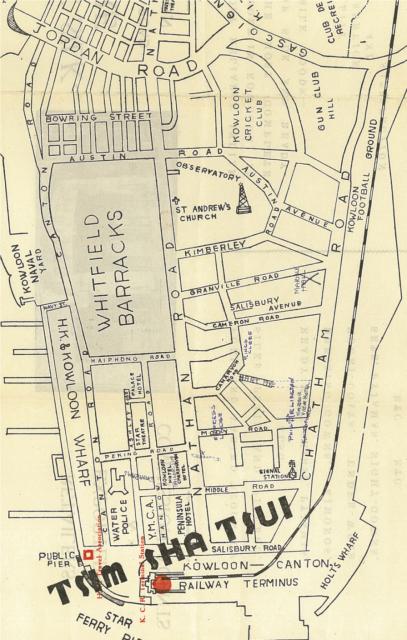
Map of TST area, but of unknown date. My guess is 1930s or 1940s. It is the map on the back of a Tailor shop's promotion leaflet. Who be happy if someone can date this more accurately.
Date picture taken
1940s
Gallery
Shows place(s)
Comments
what's the name/address of
what's the name/address of the tailor's? it doesn't seem to be marked on the map. i collect these calling cards and i have several with a similar crude map of kowloon dating from the 30s on
Re: Sketched Map of Tsim Sha Tsui, 1930s or 1940s
Hi there,
My observations:
1. No mention of Chungking Market;
2. No mention of Merlin Hotel and instead Kowloon Hotel was marked there;
3. A Chad.... something Hotel in the location of the Marco Polo Hotel (or present day Kowloon Hotel); have to rotate and enlarge a bit but still couldn't read clearly;
4. There was a Harbour View Hotel marked at Mody & Chatham;
5. Empress Lodge marked on Mody Road
6. Definitely pre-modern day Star Ferry pier;
My 2 cents,
T
Re: what's the name/address of the tailor's
Hi there,
I think it was hand written between the Kowloon & Chad-- something hotel, the location of present day Kowloon Hotel.
Best Regards,
T
Sketched Map of Tsim Sha Tsui, 1930s or 1940s
Hi Everyone,
Looking at this map an the map at http://hk.centamap.com/gc/home.aspx
Can you tell me when Kimberly Street came into existence. I am sure we lived in Kimberly street in 1955-6? Carnarvon Road slopes upwards towards Kimberly Road?
Regards
Greg
re: Sketched Map of TST
Mark,
Any chance you can read the name of the hotel next to the Kowloon Hotel, and let us know the name. That, together with the Palace Hotel might help date it.
AsThomas mentions, no sign of Chungking Arcade, which was finished in 1941. It's round shape was very ovbvious - you can see it on this 1958 map:
Another clue is the short Salisbury Avenue, which is now called Hau Fook Street. I wonder when the name changed?
Greg, Kimberley Street isn't there on a 1947 map, but is there on a 1964 map, so somewhere between those dates. It's where I lived when I first arrived in Hong Kong in 1989. I rented a room in a flat there. I think it was a four-storey building - it's been demolished since.
Regards, David
Chardhaven Hotel
Thanks for all the extra info. I've made a Place for it, and moved the information over there.
Map updated
Thanks to Mark, who sent over a better copy of the map. I've updated the image above.
Regards, David