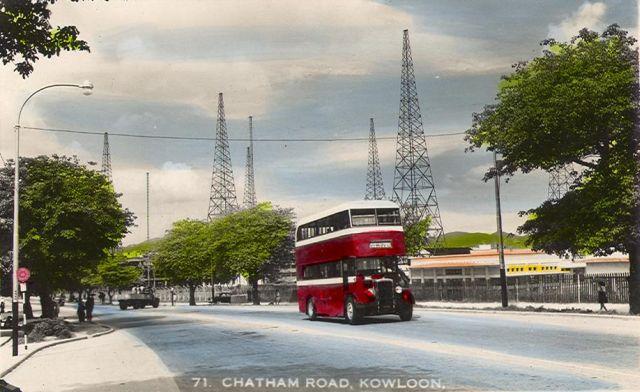
The buildings to the right of this photograph appears to be the Hung Hom Pavilions I mentioned in the article, viewed from behind. The towers behind the bus belong to the Hung Hom radio station that should be visible on any 1950s map of Kowloon.
I can see that you've already got an excellent article on the wireless station, which is good.
The funeral pavilions and the connecting railway line can also been seen from the 1949 aerial photograph in the wireless station article. They are located towards the right of the Chatham Road bend that immediately follows the triangular junction.
Ernest, well spotted. I can see them now you point them out, but I had to turn your map and photos around a couple of times til I could get them all lined up in my head!
The "Gwulo-y" way to handle this is to go ahead and create a Place for the "Hung Hom Funeral Pavilions", so we can gather information about them there, and also link any photos that show the Pavilions together. Here's the link to create a new Place (you can also find it on the left menu of every screen). Let us know if you run into any problems.
I'd also recommend you create an account and login before you make the Place. Then the Place will be markes as 'yours', and let you edit it if you need to make any corrections later.
Comments
Hung Hom Funeral Pavilions
David,
The buildings to the right of this photograph appears to be the Hung Hom Pavilions I mentioned in the article, viewed from behind. The towers behind the bus belong to the Hung Hom radio station that should be visible on any 1950s map of Kowloon.
Cheers
Re: Hung Hom Funeral Pavilions
I can see that you've already got an excellent article on the wireless station, which is good.
The funeral pavilions and the connecting railway line can also been seen from the 1949 aerial photograph in the wireless station article. They are located towards the right of the Chatham Road bend that immediately follows the triangular junction.
Cheers
I wonder why this was
I wonder why this was considered worthy as a postcard. The double decker bus ? The power towers ?
Re: Hung Hom Funeral Pavilions
Ernest, well spotted. I can see them now you point them out, but I had to turn your map and photos around a couple of times til I could get them all lined up in my head!
The "Gwulo-y" way to handle this is to go ahead and create a Place for the "Hung Hom Funeral Pavilions", so we can gather information about them there, and also link any photos that show the Pavilions together. Here's the link to create a new Place (you can also find it on the left menu of every screen). Let us know if you run into any problems.
I'd also recommend you create an account and login before you make the Place. Then the Place will be markes as 'yours', and let you edit it if you need to make any corrections later.
Regards, David