Everything tagged: boundary stone

Photos tagged: boundary stone

1949
1949
1949

Pages tagged: boundary stone

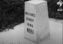
One of the Defence Lot 11 boundary stones besides Route TWSK, near Kap Lung [????- ]

Submitted by tngan on Mon, 12/23/2013 - 17:53

Spotted this one along Route TWSK after getting down from Tsuen Kam Pass through Kap Lung Ancient Trail.  This is a smaller kind of stone.  There are the routine square plate boundary stone like other military sites as well.

Location is approximate despite I put the GPS logger directly on top of the stone before making the mark.

British stone marker stating the 114'30" E boundary at sea dated 1902 [1902-2007]

Submitted by tngan on Wed, 04/25/2012 - 18:27

The marker is approximate.  However for the accuracy of the then Royal Navy Engineers/Survayers I am pretty sure the stone used to sit exactly on the 114'30" E longitude.

Thanks for JW for this piece of Old News.  Back in 2007 archeologists in Shenzhen had discover this stone marker at the tip of the Xichong (西沖)。 It was the boundary marker setup by the British for the seaward boundary concerning the taking (or lease, depends on how you look at it) of the New Territories.