The 1924 Map shows 10 & 11 The Peak were next to 'Haystack' on RBL 166.
I found a letter at the HKPRO (ref: HKRS156-1-388) from the HSBC to the Reparations Claims Registration Office, dated 25 Sep 1946:
[...] The Claim relates to a block of flats, No 10 and 11 The Peak, which were demolished by the British Forces in the course of the Japanese Attack on the Colony.
We desire to clear the site of the debris and have received a tender for the work which, if commenced by October 1 next can be carried out at a cost which owing to similar work being performed in the neighbourhood, can be done at a considerably lower cost than would otherwise be the case. [...]
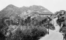
I think the ruins of the building are visible in the bottom-right corner of this photo, dated 1945:

Does anyone know when these flats were built, who owned them (HSBC ?), and why the British Forces needed to demolish them?
Regards, David
Photos that show this Place
Comments
Ruins today / 1941 demolition
GW has visited and written up what's to be found there today: https://gwulo.com/comment/31345#comment-31345
He adds:
The story of the partial demolition of the building that stood on this site is told in "Resist to the End" by Charles Barman (ISBN 978-962-209-976-0). Barman was a Quartermaster Sergeant in the Royal Artillery during the Battle of Hong Kong. The book is his diary.
The book contains two entries for 11th December 1941. There are two entries for the same date as the original diary was subsequently rewritten in an expanded form. One of the entries (Page 19) is from the original diary, whilst the other (Pages 14-16) is the expanded version.
To summarize, on 11th December 1941, Barman was informed that the Number 2 Gun at the Mount Austin Mobile Artillery Battery was unable to fire on targets in Lai Chi Kok as the gun was positioned so close to No.10 (according to the original version) or No.11 (according to the expanded version) The Peak that the building obstructed its line of fire. The solution? Fire at the building to reduce its height. This was achieved in two volleys.
On a humerous note, Sergeant Barman fired on the building in the belief that it had already been evacuated by its tenants, the Royal Army Pay Corps. Apparently not however, as he was informed shortly afterwards by an enraged Captain Thompson who emerged from the ruins complaining that he'd been relieving himself when the shelling started!
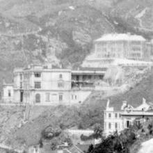
10 & 11 The Peak
10 & 11 The Peak is the block of flats on the left.
Construction Date
I've been trying to find the date when the block of flats known as "10 & 11 The Peak" was built. Unfortunately I can't find any direct evidence of exact dates, but there's plenty of circumstantial evidence. It's rather convoluted, but here goes.
Firstly, its important to recognize that the addresses "10 The Peak" and "11 The Peak" had been used by other buildings in different locations before "10 & 11 The Peak" was built, e.g. from 1914 to 1924, "10 The Peak" was the address of the residence known as "Edge Hill". Official renumbering exercises were undertaken from time to time to include buildings built since the previous exercise in a sequential numbering system.
The earliest mention I've found of "10 & 11 The Peak" was on 24th August 1923 when it was listed as a property affected by the upcoming renumbering exercise of 1st January 1924 (1). Inclusion in this exercise must surely mean that the address had some physical form at that time, being either under construction or a completed building. The previous renumbering exercise, conducted in 1914, made no mention of "10 & 11 The Peak", indicating that construction started sometime between 1914 and 14th August 1923.
The next mention of the building is in the 1924 Peak Map (2).
The key of the map reads. "10 & 11. RBL 166", meaning "10 & 11 The Peak" was situated on Rural Building Lot 166. Confusingly RBL 166 is depicted as a rectangular plot split in half with "10" in the upper half, and "11" and "9" in the lower with outlines of two buildings around "9". The map key tells us that "9" was the house called "The Haystack" (3).
The 1912 Peak map (4) shows the same divided rectangle Lot shape, but identifies its two halves as Farm Lots 60 and 61.
The same two building outlines seen in the 1924 map are also shown in the 1912 map where they are labelled "The Haystack". This means that both the building outlines on the 1924 map refer to "The Haystack", possibly the main house and an outbuilding, whilst "10 & 11 The Peak" has no building outline. Could it be that construction of "10 & 11 The Peak" was at such an early stage when the 1924 map was drafted that its outline couldn't be accurately drawn?
On 10th May 1876, Farm Lots 60 & 61, each of 43,575 square feet, were auctioned by the Government (5). I don't know the results of the auctions, but "The Haystack" appeared on FL 61 within ten years so it may have been sold at the 1876 auction.
In 1921 the Government converted FL's 60 & 61 into RBL 166 at no cost (6). With an area of 85,500 square feet, RBL 166 was only 1,650 square feet smaller than the combined areas of FL's 60 & 61. I don't understand this. Surely whoever built "The Haystack" owned FL 61, and the area of "The Haystack" was larger than 1,650 square feet, so how could FL's 60 & 61 be converted into RBL 166 without the Government compensating the owners of "The Haystack"?
I digress. For the purposes of establishing when "10 & 11 The Peak" was built, the conversion of FL's 60 & 61 into RBL 166 may be relevant as an indicator that something was about to happen to this land. To put it another way, the Government would only bother changing the land designation if they intended to develop or sell it. Unfortunately I can't find any evidence of either. I'm almost certain the site wasn't developed for the Governments own use as it doesn't appear in the PWD Reports of subsequent years. However, if it was publicly auctioned I'd expect to find an advertisement for the auction in the Government Gazette, but cannot. In later years the building is mentioned infrequently in the Jury Lists, suggesting it was a private developement rather than civil servant quarters (7).
By 1941, four HK & Shanghai Bank employees were in residence (8). The Jury Lists don't reveal if HK & Shanghai Bank employees lived at "10 & 11 The Peak" in its early years due to their habit of merely recording "on premises" as their addresses. At the head of this string David noted that in 1946 HK & Shanghai Bank was in correspondence with the Government over reparations after the British Army destroyed the building during the war. Given the relatively high number of HK & Shanghai Bank men living thereat in 1941 and the Banks subsequent interest in reparations, perhaps by 1941 they owned the building and used it as staff quarters?
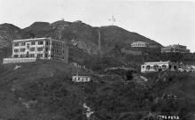
Next let's look at this photo posted by David which he dated to the 1920's.
David noted that both "Treverbyn" (9) and "10 & 11 The Peak" are present with the latter clad in scaffolding suggesting construction was nearing completion.
The 1923 PWD Report (10) talks about the construction of Stubbs Road and states, "At the close of the year...some filling in near Treverbyn remained to be done" - meaning that Treverbyn was still standing at the begining of 1924. However, the 1924 PWD Report (11) says, "A commencement was made with the 24 European flats on RBL 78,...but work was suspended from the begining of October to the end of the year". The "European flats" in question were "Peak Mansions" (12), which replaced "Treverbyn" on RBL 78. "Treverbyn" should therefore have been demolished between January and October 1924. If so, David's photo showing the almost completed "10 & 11 The Peak" must have been taken prior to October 1924.
Considering all the above evidence, I think construction of "10 & 11 The Peak" probably started sometime after the 1921 conversion of FL's 60 & 61 into RBL 166. From the 1924 Peak renumbering exercise and the 1924 Peak map we can say that construction had at least started by 1923 or 1924. Davids photo tells us that construction of "10 & 11 The Peak" had neared completion before October 1924. I'll go for 1924 as the year construction was completed.
Corrections and additional information are most welcome.
References
1. Government Gazette Notification No. 372/1923.
2. https://gwulo.com/media/13017
3. https://gwulo.com/node/5107
4. https://gwulo.com/media/13074
5. Government Gazette Notification No. 84/1876, 29th April 1876.
6. 1921 PWD Report, Page Q9.
7. The first entry I can find in the Jury List after 1st January 1924 for 10 and/or 11 The Peak is in the 1928 List when Arthur Harry GILLINGHAM of Butterworth & Swires gave it (10 The Peak) as his address. The 1931 List had another Butterworth & Swires man living thereat - Edwards Joseph DOWLEY.
8. 1941 Jury List. The bankers in residence were George Hunter CAUTHERLEY, Hugo Eric FOY, Charles Frederick HYDE and Samuel William Prittie PERRY.
9. https://gwulo.com/treverbyn
10. 1923 PWD Report, Page Q79, Para.120(c).
11. 1924 PWD Report, Page Q41, Para.42.
12. https://gwulo.com/peak-mansions