This week's newsletter looks at why the British Army built Anderson Road, how it was used, and what we found when we tried to follow its route in 2024.
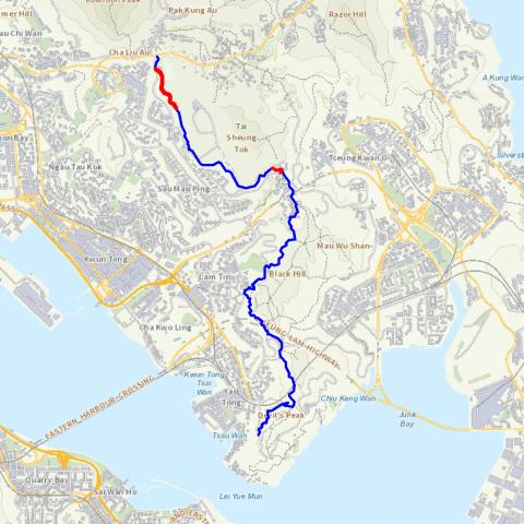
If you search for Anderson Road on a modern map you'll find two matches, both short, dead-end roads, and both in the hills above east Kowloon. I've highlighted them in red below.
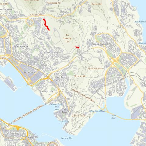
But originally Anderson Road was one, much longer road, as shown by the blue line.
The origins of Anderson Road
The book Eastern Fortress [1] is a good source for this. It explains that after the British leased the New Territories, they were concerned that a foreign enemy could land soldiers in Mirs Bay, then march them south to attack Kowloon and Hong Kong.
In the early 1910s, the man responsible for defending Hong Kong against such an attack was Major General Charles Anderson, the General Officer Commanding, British Troops in South China. He prepared plans for a defensive line, running from Lai Chi Kok to Devil's Peak along the string of peaks that overlook Kowloon. His plans called for new redoubts and blockhouses to be built, as well as new roads to enable troops to quickly move along the line to wherever they were needed. In 1912 he was given the go-ahead to build the defences he'd requested in the eastern section of the line, and 'a road from Devil's Peak to Customs Pass', i.e. Anderson Road.
The earliest map I've seen that shows the new road is a War Office map from 1922 [2], shown below.
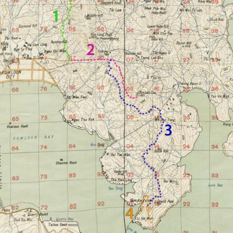
Anderson Road was part of a network of roads, that I've labelled as follows:
- Jat Incline
- Road to Customs Pass and Chin Lan Chu
- Anderson Road
- Road from Sam Ka Tsuen pier to the Gough and Pottinger Batteries
The map key says these are all 'Roads suitable for man-handled guns', as opposed to the 'Government motor-roads'.
Anderson Road in wartime
In December 1941, the fears of an attack from the north came true when Japan declared war on Britain, and Japanese troops crossed from China into the New Territories. The 5th Battalion of the 7th Rajput Regiment were part of the forces opposing the Japanese advance, defending the eastern areas of the New Territories. When they were given the order to retreat to Hong Kong Island, the Rajputs made their way to the pier [3] below Devil's Peak, where boats were waiting to ferry them across to the island.
The Rajputs' war diary [4] of these events makes several mentions of Anderson Road. Excerpts:
- 11 December
- 1500 hrs. [...] The 2/14 Punjabis would move behind me down ANDERSON ROAD and be evacuated and the 2 R.S. would withdraw via KOWLOON. Calculated I could expect 2/14 about 2000 hrs. ((2/14 Punjabis = 2nd Battalion, 14th Punjabi Regiment. 2 R.S. = 2nd Battalion, the Royal Scots Regiment. These were the battalions manning the central and western areas, respectively.))
- 1700 hrs. [...] Colonel Kidd ((of the 2/14 Punjabis)) phoned to say he would pass CUSTOMS PASS about 2000 hrs. Gave orders for Provost Staff and Intelligence Officer to establish checking Posts for them at both JATS INCLINE Rd junction and ANDERSON RD take-off.
- 12 December
- 0400 hrs. Met Lt-Col KIDD on ANDERSON Rd. with two Coys of 2/14 having at last reached HAI WAN after a very trying march. "D" Coy arrived in rear of this party.
- 2215 hrs. "A" & "B" Coys to be clear of MAU LA TONG line by 0001 and to withdraw, "A" Coy to Adm. Area via ANDERSON Rd., and "B" Coy to right of "C" Coy on the HAI WAN line.
- 13 December
- 0100 hrs. Bn. HQrs moved back to re-entrant behind HAI WAN on ANDERSON ROAD.
- ((By 0730 hrs the troops had all withdrawn to the pier and were ferried across to the island.))
Anderson Road today
Do any traces of the military road remain? Last week I set out with friends Phil and Pete to see what we could find.
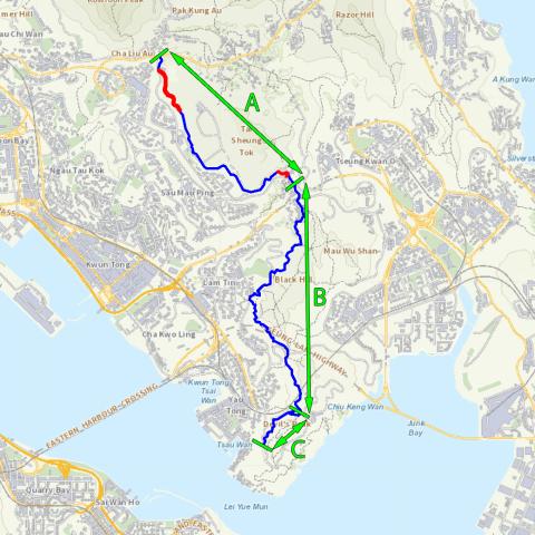
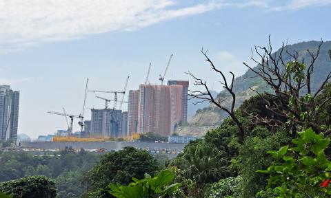
I've split the road into three sections. The first section, Section A, runs from Clear Water Bay Road to Po Lam Road, starting and ending with those two dead-end roads. All the middle part of that section is currently off limits as it is a huge construction site. It used to be the old Anderson Road Quarry, but the quarry was closed some years ago, and now there are new housing blocks being built there. With no easy access, and the likelihood that all the redevelopment would have destroyed traces of the old road, we skipped Section A, and started at Section B instead.
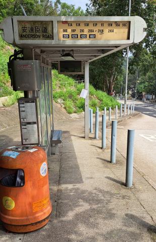
We caught bus 98A at Kwun Tong towards Po Lam Road and got off at the obvious stop: Anderson Road!
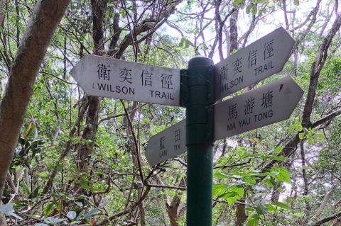
The start of Section B of Anderson Road follows the Wilson Trail, so it's easy to find. We left Po Lam Road and turned into Ma Yau Tong Road.
From Ma Yau Tong village there are views back towards the old quarry site, where all that construction is underway.
After a few minutes walking the road came to an end, and we were on to a narrower path.
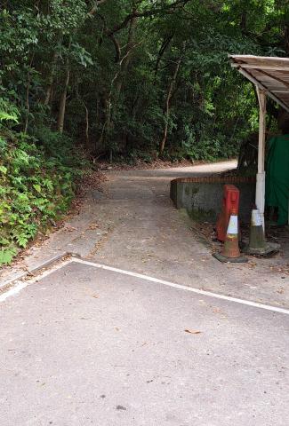
At the point where the Wilson Trail turns left to head up a staircase, we carried on along the level path, signposted to Lam Tin.
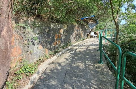
At first glance we were on a typical Hong Kong concrete path, passing over a typical Hong Kong concrete drainage channel.
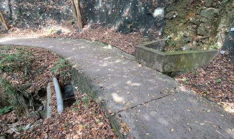
But if you look at the outflow of that channel you can see it was built from neatly cut stone blocks, making it an older structure.
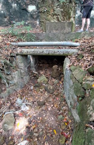
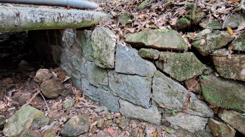
We'll see many more of these old stone-lined drainage channels along the route. They're a good clue that you're on the right track, and still following the old Anderson Road.
Steps, on the other hand, are a red flag.
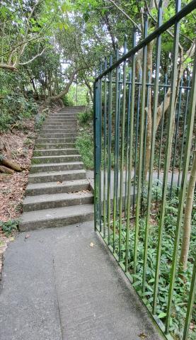
Remember the map key that differentiated between 'Roads suitable for man-handled guns' and 'Government motor-roads'? Anderson Road was one of the former, and although soldiers may have carried some heavy loads along it, most of the heavy carrying was done by mules. The road was carefully laid out to have gentle gradients, avoiding the need for steps. Sure enough, if we look at the route of the old road it turned right to follow the contour around the ridge, rather than taking the steeper shortcut over it.
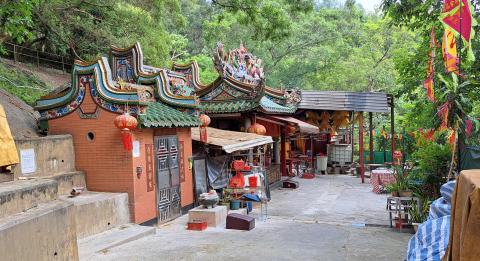
There is still a path along the original route, and if you follow that you'll pass through this colourful temple before meeting the other side of the staircase.
Apart from the old drainage channels, the other clue to look out for is retaining walls built from stone. They aren't always obvious from the path, but if you see an unnaturally straight edge to the slope below the path, it's worth a closer look to see if it is one of the stone walls.
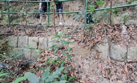
Again, seeing one of these is reassurance that we're on the right track, something that will become much more important on the final section.
From here it's a straightforward walk, following the concrete path until you get near to O King Road. When the cutting for O King Road was dug, a short section of Anderson Road was lost. I suggest you walk along the slope to rejoin the Wilson Trail, then follow the Trail down to O King Road and up the other side. As you walk along the Wilson Trail towards Yau Tong, you're back on Anderson Road again. Though it looks like a regular, modern, concrete-and-railings trail, again there's a section with a stone retaining wall both above and below the path, showing that we're on still on the route of the old Anderson Road.
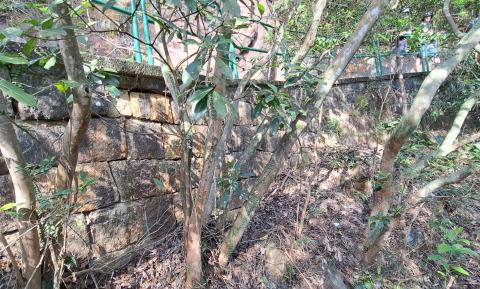
I remember seeing the upper wall years ago when I was walking the Wilson Trail for the first time, and wondering why there was an old wall in the area. Good to have an answer at last!
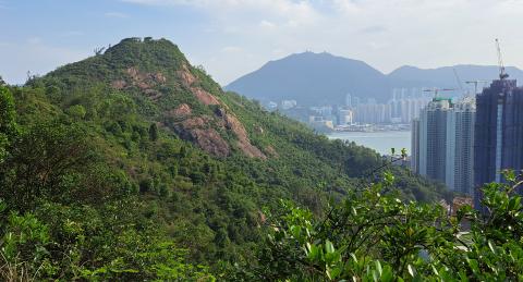
Around here you also get views of Devil's Peak with Hong Kong Island in the distance - the destination that the soldiers were aiming for in December 1941.
Where the trail reaches a gap in the ridge we stopped to enjoy the cool breeze, and the views over the cemetery and Junk Bay towards Lohas Park.
Here's a map of this area with that view point marked.
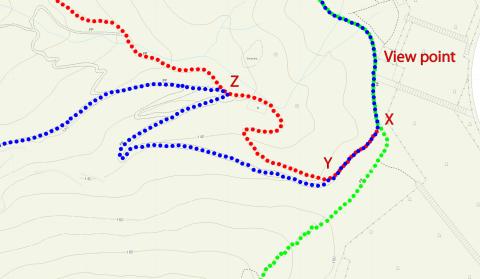
From there we continued along the Wilson Trail (green) to the junction at X, which marks the end of Section B of our walk. If you've had enough you can continue along the Wilson Trail towards Yau Tong and civilisation. Or to start on the final Section C follow the red path downhill.
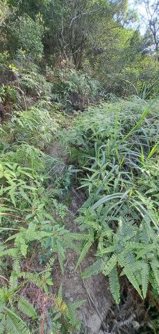
You'll soon be on steps, which aren't very mule-friendly. If you look to the left at Y you can see a cut into the slope where the Anderson Road (blue) zig-zagged back and for to give the mules an easier journey. Carry on down the red path. You'll pass a ruin [5] on your left, then at Z you'll see Anderson Road turn off to the left. Not super clear, but not very overgrown either, it looks like this.
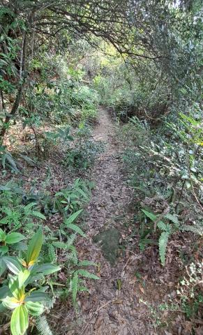
It gets clearer after a while.
There are more drainage channels along this section, including this one that was built from concrete.
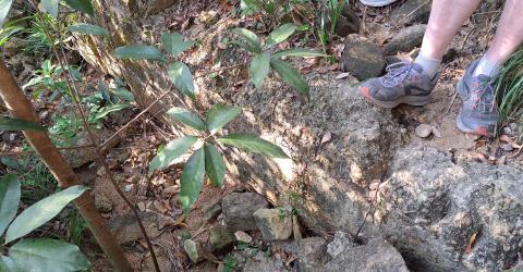
Eventually you'll reach this rock face, and if you look carefully you'll see there are fasteners fixed into the rock.
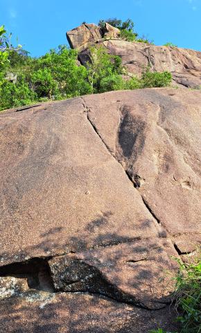
In cooler weather this is a popular place to practice rock climbing, which explains why this section of the path isn't too overgrown - it is kept clear by the climbers walking in and out.
After this, the highlight was seeing a length of the old Anderson Road looking much like how I imagine it would have looked in 1941.
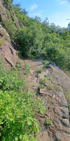
Enough room for mules and soldiers, but definitely not for motor vehicles!
After this point there are still plenty more drainage channels and retaining walls to spot, but there isn't anything you haven't already seen, and the old Road becomes more and more overgrown. You may want to turn back here and walk out on the Wilson Trail.
If you decide to continue, eventually you'll see the road to the cemetery and this pavilion below you, which means you've reached the end of Anderson Road. Congratulations!
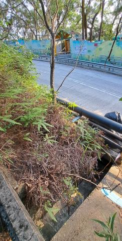
Make your way down the slope, then carefully climb the barrier and cross the road to get to the pavement. From there you can follow the road downhill and head over to Yau Tong MTR station.
Exploring Anderson Road
If you'd like to explore Anderson Road and you have a phone with GPS and mobile data you can use the Gwulo 'street' page for Anderson Road - it was a big help for us on our walk. I've marked the line of the old road on that page's map, so you can zoom in to see the detailed route at any point, and use GPS to check your location. It defaults to show the government map, which is the best for seeing the physical features of the land. Sometimes it is also helpful to see the different trails that exist, and it's easier to see them if you switch to the Open Street Map.
Who was Anderson Road named after?
Given that this was a military road, built according to a plan created by the GOC (General Officer Commanding), Major General Anderson, I feel confident that the road was named after him. There is a similar example over on Hong Kong Island, where an earlier GOC, Major General Black, proposed a road to ease the movement of troops across the island. The road was built, and today we know it as Black's Link.
What does the AI say?
I've recently been interested to see how the new Artificial Intelligence tools can help with historical research. I asked Gemini-1.5-Flash: who was anderson road in kowloon named after
It confidently replied with a seemingly believable but actually impossible answer:
Anderson Road in Kowloon, Hong Kong, was named after Sir John Anderson, the Governor of Hong Kong from 1935 to 1941.
Sir John Anderson played a significant role in Hong Kong's development during his time as Governor. He implemented several reforms, including the establishment of the University of Hong Kong and the Hong Kong Housing Authority.
The road was likely named after him to honor his contributions to the city.
Sir John Anderson was a Governor, but was never the Governor of Hong, and died in 1918! (source: Wikipedia) The problem where AI returns false or misleading information is common enough that it has its own name - an AI hallucination.
References and further reading:
- Eastern Fortress - A Military History of Hong Kong, 1840-1970, by Kwong Chi Man and Tsoi Yiu Lun, is an excellent resource to understand how and why Hong Kong's military defences have changed over the years.
- The 1922 War Office map of Hong Kong is held in the UK National Archive, their ref: FO 925/25227. A digital overlay copy can be viewed at Hong Kong Historic Maps by selecting layer 1922 Hong Kong.
- The pier that the Rajputs were heading towards in December 1941 is the Sam Ka Tsuen Pier.
- The Rajputs' War Diary is available at the UK National Archive, their ref: WO 172/1692
- The ruined building near the start of Section C was the Devil's Peak Anti-Aircraft Searchlight Engine Room
- If you enjoy exploring Hong Kong's streets and countryside, here are some other walks we've done, with notes about Hong Kong's history along the way:
Comments
Military Roads
Fantastic field trip! Though in Las Vegas Nevada, USA, I was definitely with you in-spirit on your field expedition.
One thing to consider: I've researched US military coast/harbor defense installations, and one feature that was employed at various temporary encampments and permanent military forts in the USA, especially in-terms of coastal defense gun batteries and associated systems like early warning RADAR sites in the WW-II era is that as part of the overall camouflage efforts like native vegetation and camo netting, the US Army Coastal Artillery Corps would also extend access roads well-beyond the actual site the roadway was designed-for, and also put in fake roads/Jeep trails. This was done because the coast defense gun battery, spotting stations, etc. were all at 'secret' locations and they didn't want an enemy spy in a hill or mountain above, or traveling over the installation in an aircraft, to simply track a roadway and identify the location of an otherwise hidden facility by seeing the roadway either dead-ended at it, or had a turn-off/parking area. For these US Coast Defense/Harbor Defense gun sites, the troops assigned to them were even forbidden to step-outside and smoke a cigarette at night, for fear that over time, even the brief flicker of Zippo lighters or lit matches, spotted from a distance, would give-away the locations of camouflaged facilities.
Anderson Road
My recollection of Anderson road is that it was used to access Rennie's Mill by road. But I never made the trip, so might be mistaken
Later, in 1970-72, I lived in Clearwaterbay and commuted to my factory in Kwun Tong. In those days the Choi Hung roundabout was the mother and father of all traffic jams, and one way to bypass this was to spear off to the left near the top of the big Clearwaterbay Rd hill and go along Anderson Road to a spur that dropped down into Kwun Tong. There were two drawbacks: after mile or so the "road" became a dirt track which wore through normal road tyres in next to no time, and there was a lot of quarrying going on in the area roughly where Shun Lee estate is now, so you were jousting for road space with 30 ton trucks being driven at high speed. The traffic jam was calmer.
Re: Chin Lan Chu
Hi There
Chin Lan Chu is likely the officials who did not have local language skills that could not distinquish the dialect being used and made up the sound based on what they heard, or being told. On some present day maps, that peak is called Tai Sheung Tok (大上托), while sometimes it has an alias of Jiu Lan Shu (蕉欄樹).
T
Anderson Road
I grew up on Anderson Road in the 1960s. Drove it back and forth to school and all activities every day. I knew every curve, village, and hut along the way. (At that age, I knew the number of curves in the road but can't remember the number now!) I lived on the grounds of Haven of Hope Hospital which is still there. We would play in the surrounding hills, including hiking up to old Rennie's Mill. I enjoyed reading this history of the road which I did not know.
Who was Anderson Road named after?
AI is definitely wrong. Anderson Road is named after Alexander Anderson (the man who actually built it). How do I know this? Because Alexander is my wife’s grandfather. Alexander Anderson also built the “Anderson Bridge” in Singapore. If you walk right along the Anderson Bridge (in the middle of the road - beware of traffic) you will find brass plaques on either end of the bridge and also in the middle. The plaques say “A Anderson” + the date it was built. Alexander Anderson was actually a New Zealander. Peter Anderson (my wife’s father) was born in Shanghai in 1924. Alexander had been in China sporadically from the early 1900’s.
I have a photo of Alexander. Unfortunately, this site won’t allow me to post a photo.
Anderson Road
Just to add a bit of further confusion to the discussion, "Signs of a Colonial Era" states (P.85) that the road is named after William John Anderson (Controller of Stores - Govt Supplies).
Anderson Road - Naming
It seems a little odd that Anderson Road would be named after the “Controller of Stores - Government Supplies”, rather than the person that actually built/engineered the road (Alexander Anderson).
Unfortunately, my wife’s father (Alexander Peterkin Anderson - who went under the name “Peter”) passed away in 1994 (so I am unable to ask further details). Peter was an only child (as is my wife). Having said that, my wife has visited Hong Kong as a child countless times. Peter never had a single doubt as to who Anderson Road was named after. It was his father (Alexander Anderson).
Peters godfather was the “Duke of Norfolk”, and my wife’s mother recalls visiting him in London. Alexander and “the duke” were best friends from his time in China. Alexander also imported the first welding machine into China from Scotland, and he used this to build railway carriages.
Alexander married Viola May Peterkin (a Scottish Barbadian). Viola (my wife’s grandmother) was the daughter of Thomas Peterkin (a plantation owner). When Thomas Peterkin died in 1900, Viola and her two sisters were reportedly the three richest spinsters in the world. The family home in Barbados is now a 20 room hotel. The family “holiday home” is now owned owned by Vivian Richards (the cricketer).
It seems logical that Viola would not have married a man of little social importance. Again, Peter had zero doubt about who Anderson Road was named after. Unfortunately, the only remaining Anderson/Peterkin family line are my wife and daughter. All the others never married or were childless. There is no one else to ask about the history.
I knew Peter well, and I can say without hesitation he wasn’t the type of person who would make up lies about anything. He was honest to a fault. He was highly educated, spoke 7 languages fluently and had an IQ of 171. His father spoke 9 languages and his mother 14.
Given the choice between William Anderson and Alexander Anderson as the source of the naming of Anderson Road, I would back Peter Andersons version of events 100%.