Current condition
Demolished / No longer exists
Date completed
(Day, Month, & Year are approximate.)
Date closed / demolished
(Day, Month, & Year are approximate.)
(Updated 18 December 2025)
Sources:
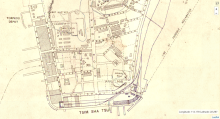
(1) 1920 Railway Boundary Plan
(2) 1920 Kowloon map at https://gwulo.com/node/59200#19~22.30034~114.17459~Map_by_GovHK-Markers…
(3) 1938 Street Index Page 234 or Image 428 comprising two villas No. 1 thru No. 4. Likely they were semi-detached houses.
An early reference of Ormsby Villas can be found in the 1899 Jurors List : Humphreys, William Myrick, Clerk, National Bank of China Ltd, residing at 1 Ormsby Villas. A birth was also recorded at Ormsby Villas in October 1899. Hong Kong Daily Press 30 October 1899 refers.
Tentative completion year 1899. Demolished around 1948 based on comments below.
Later place(s) at this location
Photos that show this Place
1903
c.1920
1924
Comments
Map evidence for dates completed/demolished
Hi Moddsey,
I've been researching the subsequent buildings built on this land lot and came across further info about Ormsby Villas:
1. Map of Kowloon from 1901 by the Public Works Department shows this whole north side section of Granville Road as still an empty land lot, IL 540. View here: https://hkmaps.hk/map.html?1901.2
2. Military survey maps from 1904 and 1912 now show two squarish blobs at the approximate location of Ormsby Villas, though they're not labelled as such. View here: https://hkmaps.hk/map.html?1904 and here: https://hkmaps.hk/map.html?1912
3. The 1920 map by the Public Works Department now shows the two villas clearly drawn, but not named. View here: https://hkmaps.hk/map.html?1920
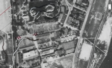
4. This is corroborated by aerial photos from 1924, which clearly show the two villas. View here: https://hkmaps.hk/map.html?1924.1
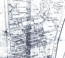
5. Both villas show up on maps from 1936, 1945, and 1947. However, aerial photos taken on 24 April 1949 by the Joint Air Reconnaissance Intelligence Centre show that by this date the villa on the right had been demolished, and the villa on the left had been replaced by several small structures. View here: https://hkmaps.hk/map.html?1949.1
6. The next available map I could find was a 1955 one by the Land and Survey Office, showing that the small structures replacing the left villa had also been demolished, and the land where Ormsby Villas stood had become shophouses. View here: https://hkmaps.hk/map.html?1955
So from that, I'd propose a completion date of around 1902-1903, and demolition dates of 1947-1949 (for the right villa) and 1949-1955 (for the left villa). I'll upload some screenshots of these maps as well, for reference.
Re: Updated Information
Thanks for the additional information.
I have made a tentative completion date of 1899 as Ormsby Villas were occupied that year.
In this photo from 1947, Ormsby Villas appear to be present. The villas have disappeared in the 1949 aerial photo. Split the difference, I have made a tentative demolition date of 1948.