Current condition
Demolished / No longer exists
Date completed
(Day, Month, & Year are approximate.)
Later place(s) at this location
Photos that show this Place
1900s
1911
1920s
Comments
Ebordale
Marked as 48 The Peak on the 1909 map and 157 The Peak on the 1924 map.
RBL 114.
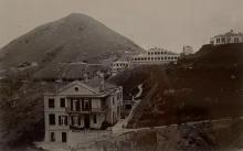
Seen here...
...mainly of the gable end about a quarter in from the right side of the pic. The three storey building. The roof just touches the ridge line.
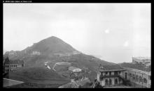
Again here...
...the three storey building just below the right hand end of the War Memorial Hospital (the longest building on the ridge line)
A little bit further west?
Looks like it was the site of today's King's Court:
https://gwulo.com/node/36120#17/22.26486/114.15092/Map_by_ESRI-1912_Pea…
Yep, fair enough.
Thanks David, I've moved the marker.
Ebordale
Ebordale was built on RBL 114 according to the 1912 (1) and 1924 (2) maps. RBL 114 was put up for public auction on 2nd June 1903 (3). Although the result is unknown, it is likely to have been sold at that time as only nine months later, on 18th March 1904, the house was listed as "New House" in the Peak Renumbering Exercise (4), suggesting it was nearing completion or already completed at that time.
It's unlikely that a substantial house such as Ebordale would have been completed in under six months, so I've picked 1904 as the construction completion date.
1. https://gwulo.com/media/21978 .
2. https://gwulo.com/media/13017 .
3. Government Gazette Notification 314/1903 .
4. https://gwulo.com/node/34922 .
Ebordale/Edordale/Holmdale
The name "Ebordale" changed to "Holmdale" around 1924. The Peak Renumbering Exercise (1) of that year noted the address change from No.44 to No.157 The Peak and the new name of "Holmdale". However, although the 1924 Peak Map (2) labelled it with the new number, it retained (but misspelt) the old name - "Edordale". The 1924 PWD Report (3) referred to it as No.157, noted that a new porch, bedroom and other small alterations had been completed and that the house was occupied by the Captain Superintendent of Police.
Photos from its earliest days up to the 1950's appear to show the same building remained largely intact throughout.
The 1950's map (4) labels it as "Holmdale Government Quarters"
1. Peak Renumbering Exercise of 1 Jan 1924, Government Notification 569/1923.
2. 1924 Peak Map at https://gwulo.com/media/13017
3. 1924 PWD Report, Para.47.
4. 1950's map at https://gwulo.com/media/14175