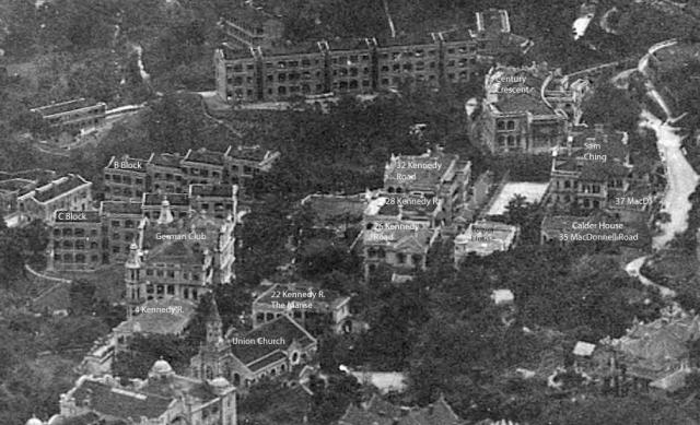
Cropped from A bird's-eye view of Hong Kong 1910.
This photo is slightly enhanced and annotated. Streets do not need to be marked as MacDonnell Road can be seen clearly, and also Kennedy Road can easily be estimated.
On the northern side of Kennedy Road, we see 4 Kennedy Road, the German Club, and then C Block and B Block of Victoria Barracks. St. Georges Building and St. Joseph’s College have not been built yet.
On the southern side, we start again with Union Church on Kennedy Road, followed by 22 Kennedy Road. The Manse was built close to the street. Calder Path is hidden behind trees. The next three buildings do not stand close to Kennedy Road as seen in the 1924 aerial photograph.
1 Calder Path can be seen clearly, and also why it bears the name “Tower House”. The tower is at the north-western edge, close to Calder Path. 2 Calder Path hasn’t been built yet (that was in 1916).
At the junction with MacDonnell Road is Calder House with house number 35. East of it is 37 MacDonnell Road as listed in the 1938 street index.
In 1910, there was one building at Calder Path on the western side, and three on the eastern side.