The utility box and the building at the rear can be viewed as in the original photo.
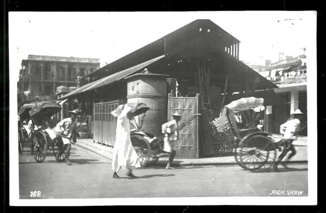
The photo below also appears on Pg 107 'Early Hong Kong Eateries'. The description reads 'Kansu Street with a view of Battery Street circa 1925. Yau Ma Tei Market (right) housed food stalls and small eateries.'
Perhaps other contributors can verify the cross streets.
If we are looking along Kansu St towards Battery, is that building on the corner of Kansu/Battery? If so, the road with the utility box is Reclamation Street and the market area is where the jade hawker bazaar is now?
thanks moddsey for the clarification. So Battery Street on the left looking up (north) towards Kansu Street. The market is therefore the site of the current YMT Market building. On the 1920 Kowloon map it has "retail market" marked on the same site and the utility box was therefore on the NE corner of Pak Hoi St/Battery St.
On the same map you can see that the market building occupied the east side of the plot, so I assume that corresponds to the structure with pillars that can be seen on the right hadn side of Alexandre's postcard?
A seller of the same photo at an auction site mentions: "This is a black and white real picture postcard of Praya Central, Hong Kong, China. It shows a beautiful lively view of Rickshaws with a Market or Station in the background. The postcard was published in the 30s..........."
I have seen the original photo before for sale but never had time to confirm the actual location as Hong Kong.
The utility box and the building at the rear are a starter for guessing the location of the original photo but I think more photo evidence is required to make an accurate determination.
In the upper space on the left in the "eateries" image you linked to you can just make out the distant ridge of Beacon Hill. It's faint but it's there and the angle matches perfectly with what would have been the view from Battery Street. Also, at the other side of the open space (at the end of Battery Street) is a sharp turn to the left. This ties up exactly with Reclamation Street at the junction with Public Square Street. Other factors such as the ones previously mentioned, and the open space where the Jockey Club clinic now stands, all appear to point to Battery Street.
Been investigating the original photo from other sources. A local seller of the same photo postcard names the location as “Yaumatei Market”. Under supplementary information, “Market Street, Yaumatei, Kowloon, circa 1950s” is given.
The area should be visible on the 1945 aerial photograph. It looks as if the market is more or less an empty space (between C and the watermark). A single building at Kansu Street can be seen, and also a curved building on Reclamation Street.
Thank you folks for identifying the location. The 1956 map shows a bus route for the street (Battery Street) on the left of the photo reminding my bus to/from (I think north bound here) Jordan ferry pier (primary 1 on Wai Ching Street). I don't remember the building, but the utility box must be the same one I saw from upper deck, so it was still there in 1950-51. Regards, Peter
Comments
Market St
Perhaps this is a view of Market Street (left to right) where it intersects with Shanghai St (on the left)?
Market/Shanghai Streets
This photo should show the same place almost 30 years later:
Yau Ma Tei Market
A similar scene posted below at: https://gwulo.com/media/26488
The utility box and the building at the rear can be viewed as in the original photo.
The photo below also appears on Pg 107 'Early Hong Kong Eateries'. The description reads 'Kansu Street with a view of Battery Street circa 1925. Yau Ma Tei Market (right) housed food stalls and small eateries.'
Perhaps other contributors can verify the cross streets.
Kansu St
If we are looking along Kansu St towards Battery, is that building on the corner of Kansu/Battery? If so, the road with the utility box is Reclamation Street and the market area is where the jade hawker bazaar is now?
Re: Kansu Street
Mention is made at: https://www.pinterest.ca/pin/553168766731898023/ of the cross streets. Battery Street is on the left.
Battery St
thanks moddsey for the clarification. So Battery Street on the left looking up (north) towards Kansu Street. The market is therefore the site of the current YMT Market building. On the 1920 Kowloon map it has "retail market" marked on the same site and the utility box was therefore on the NE corner of Pak Hoi St/Battery St.
On the same map you can see that the market building occupied the east side of the plot, so I assume that corresponds to the structure with pillars that can be seen on the right hadn side of Alexandre's postcard?
Original Photo and Details
Hi Phil,
A seller of the same photo at an auction site mentions: "This is a black and white real picture postcard of Praya Central, Hong Kong, China. It shows a beautiful lively view of Rickshaws with a Market or Station in the background. The postcard was published in the 30s..........."
I have seen the original photo before for sale but never had time to confirm the actual location as Hong Kong.
The utility box and the building at the rear are a starter for guessing the location of the original photo but I think more photo evidence is required to make an accurate determination.
praya central?
In the upper space on the left in the "eateries" image you linked to you can just make out the distant ridge of Beacon Hill. It's faint but it's there and the angle matches perfectly with what would have been the view from Battery Street. Also, at the other side of the open space (at the end of Battery Street) is a sharp turn to the left. This ties up exactly with Reclamation Street at the junction with Public Square Street. Other factors such as the ones previously mentioned, and the open space where the Jockey Club clinic now stands, all appear to point to Battery Street.
Heritage Impact Assessment
The following heritage impact assessment of buildings of cultural significance in Yau Ma Tei may be useful to readers:
https://www.aab.gov.hk/filemanager/aab/common/189meeting/HIA_Report_YMTT.pdf
Yau Ma Tei Market
Been investigating the original photo from other sources. A local seller of the same photo postcard names the location as “Yaumatei Market”. Under supplementary information, “Market Street, Yaumatei, Kowloon, circa 1950s” is given.
Market Street
I made the same assumption in my original assessment but after seeing the wider area can see it's not correct.
1930s Yau Ma Tei Market
An enhancement to a previously posted photo showing Battery Street on the left and looking up towards Kansu Street.
YMT Market area
The area should be visible on the 1945 aerial photograph. It looks as if the market is more or less an empty space (between C and the watermark). A single building at Kansu Street can be seen, and also a curved building on Reclamation Street.
Yau Mei Tei Market 1924, by…
Yau Mei Tei Market 1924
Extract from HK map dated 1924, Yau Mai Tei Retail Market
Re: Yau Ma Tei Retail Market
Suggest to change the photo titles to Yau Ma Tei Retail Market as confusion may arise with other photos of the Fruit Market etc.
Yau Ma Tei Retail Market
Thank you folks for identifying the location. The 1956 map shows a bus route for the street (Battery Street) on the left of the photo reminding my bus to/from (I think north bound here) Jordan ferry pier (primary 1 on Wai Ching Street). I don't remember the building, but the utility box must be the same one I saw from upper deck, so it was still there in 1950-51. Regards, Peter