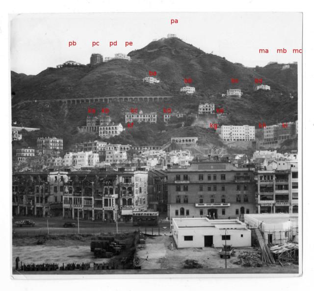
Bowen Road and Kennedy Road
ba - 17 Bowen Road
bb - 16 Bowen Road
bc - 15 Bowen Road
bd - 14 Bowen Road
pc - Interocean Court under construction
Date picture taken
1950s
Gallery
Shows place(s)
Comments
Annotated photo
It would be of interest if the annotated buildings could be identified and listed.
Hello, if ka and kb marked…
Hello, if ka and kb marked in the picture are No. 50 and No. 52 Kennedy Road?And kc is St Francis' Canossian College. Looking forward to your reply, thanks.
Probably solved in gwulo (or…
Probably solved in gwulo (or somewhere) with references of different numbering schemes (need some time to find that). But with the modern scheme of Kennedy Road:
ka: No. 60 (now part of Sakura Court)
kb: No. 58 (now part of Sakura Court)
kc: No. 54 and 56 (now Ewan Court)
Thanks for your professional…
Thanks for your professional correction. Per the current positioning, please check whether the following is correct.
kd: Nos. 50–52 (now Man Yuen Garden). No. 52 (now 52B) is the three-storey portion on its left, and No. 50 (now 52A) the right portion.
ke: No. 48 (now Monticello)
On The Peak
Based largely on the 1950’s “Road Map Of The Peak District” (map ref 1954.1 on www.hkmaps.hk ) I reckon;
Pb. No 535 The Peak with 536 seen in part behind it.
Pc. As stated previously – Interocean Court.
Pd. No 537 or No 538 The Peak.
Pe. No 539 The Peak.
Pa. 30 Magazine Gap Road which was part of Cameron Mansions. The old terrace can be seen on the left of 30.
Ma. Durisdeer, No 511 The Peak.
Mb. Katoomba, 513 The Peak.
Mc. Holmedown, 510 The Peak.
I’m not 100% sure about Ma, Mb or Mc. The reason for picking them is because the land falls away to the left of Ma, meaning that we’re looking at the ridgeline on the west side of Magazine Gap rather than the east. The ridgeline on the east side must be largely obscured behind the hillside. Durisdeer was the first house on the ridge to the west of Mag Gap, Holmedown the second. If those two are correct then Katoomba is the best fit for the house below. Happy to be proved wrong.
Thanks gw — those Peak ridge…