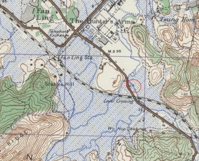
Greetings. In the 1952 map, I looked at the same area marked by the red circle shown on this map. At the level crossing, that map shows a spur line branching off from the main line, loops partially around Wo Hop Shek and goes south for a short distance then stops at a hill. It says "Under Construction".
This spur line has been razed and the area has turned residential. What was the purpose of the spur line? Thanks in advance for the feedback. Regards, Peter
Greetings, and thank you Phil for the rapid response with interesting information and photos. Elders in my family and I travelled there by car. After the cemetary visit, the food offerings including tasty BBQ pork were distributed for everyone to take home.
Since the cemetary was well known at that time, I guess to avoid association shops and companies avoid using the same name. The closest one I know near my home was a carpentry shop named Hop Wo Wood Shop. Regards, Peter
Comments
Railway track - spur line at Fanling
Greetings. In the 1952 map, I looked at the same area marked by the red circle shown on this map. At the level crossing, that map shows a spur line branching off from the main line, loops partially around Wo Hop Shek and goes south for a short distance then stops at a hill. It says "Under Construction".
This spur line has been razed and the area has turned residential. What was the purpose of the spur line? Thanks in advance for the feedback. Regards, Peter
1952 map - https://gwulo.com/jubilee-buildings?a=1#14/22.4897/114.1513/Map_by_ESRI…
Wo Hop Shek Spur line
It was a spur line for the cemetery. See here: https://industrialhistoryhk.org/hop-shek-spur-line/
Wo Hop Shek Spur Line
Greetings, and thank you Phil for the rapid response with interesting information and photos. Elders in my family and I travelled there by car. After the cemetary visit, the food offerings including tasty BBQ pork were distributed for everyone to take home.
Since the cemetary was well known at that time, I guess to avoid association shops and companies avoid using the same name. The closest one I know near my home was a carpentry shop named Hop Wo Wood Shop. Regards, Peter